North Hutchinson Island
North Hutchinson Island is an Atlantic coastal barrier island on the east coast of Florida in the United States. The island is known for clean expansive beaches, wildlife preserves, parks, shops and restaurants.
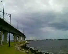 The Ernest Lyons Bridge in Sewall's Point, Florida, which carries highway A1A and connects Sewall's Point to North Hutchinson Island. | |
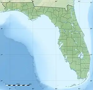 North Hutchinson Island North Hutchinson Island  North Hutchinson Island North Hutchinson Island (North Atlantic) | |
| Geography | |
|---|---|
| Location | North Atlantic |
| Coordinates | 27°33′25″N 80°19′29″W |
| Administration | |
| State | Florida |
| County | St. Lucie |
Description
North Hutchinson is an Atlantic barrier island located on Florida's Treasure Coast approximately 110 miles (180 km) north of Fort Lauderdale. State Road A1A is the main road for the length of the island, and four bridges provide access to the mainland. For most of its length, A-1-A is known as Atlantic Beach Boulevard.[1] North Hutchinson Island has many county and state parks and preserves, and is one of the few areas on the east coast of Florida with several accreting (growing) beaches.
A number of restaurants, hotels and shops are located on, or easily accessible to the island. Activities on North Hutchinson Island include fishing, snorkeling, boating, kayaking, hiking, biking, surfing, parasurfing, paddleboarding, and wildlife observation. On the northern end of the island is Pelican Island National Wildlife Refuge, the nation's first refuge was established by President Theodore Roosevelt in 1903 with over 5,400 acres (22 km2) of protected waters and lands.[2] Avalon State Park located on A-1-A near the St. Lucie County line provides a number of recreational opportunities and its beach is used by visitors for swimming, snorkeling, surfing, and scuba diving. The area ecosystem provides a habitat for varied marine wildlife including manatees, dolphins, sea turtles, many species of fish, and birds.[3]
Residential development
Residential development on the island is interspersed with parks and wildlife preserves. East of Hwy A-1-A, oceanfront residential development consists of single-family homes and low/mid-rise condominium apartments bordering or accessing the Intracoastal Waterway - a 3,000-mile (4,800 km) inland waterway along the Atlantic and Gulf of Mexico coasts of the United States. Residential development west of A-1-A and bordering the Atlantic ocean consists of single-family homes, town homes, villas and low-rise condominium apartment buildings.
Vero Beach
The city of Vero Beach lies on both sides of the Indian River, with its main business and residential areas on the mainland. Two of the island's four bridges from the mainland lie within the ciy limits. The Riomar Country Club built in the 1920s set the tone for residential development on the island. The City of Vero Beach and counties located on North Hutchinson island have adopted planning and zoning regulation to support and protect the area's natural beauty.
The developer of the Vero Beach Resort and Spa has submitted plans to build a luxury resort that is expected to include a hotel and nine private cottages on the site of the former Radisson hotel located at 2600 N A1A on North Hutchinson Island. Heaton is also the developer of the Tarpon Flats neighborhood on the west side of A1A in the 3000 block of A1A.
Sites of interest
Sites of interest on/near North Hutchinson Island include:[4]
- Sebastian Inlet State Park, located on the north end of the island and extending across the Sebastian Inlet into Brevard County.[5]
- McLarty Treasure Museum at Sebastian Inlet State Park[5]
- Fort Pierce Inlet State Park[6]
- The National Navy UDT-SEAL Museum, on the east side of A-1-A just south of Pepper Park Beach. (3300 N A1A)[7]
- Pepper Beach Park, on the southern end of North Hutchinson Island along A-1-A. It has fishing piers and public beach access with picnic facilities.[8]
- Jack Island State Preserve, on the west side of A-1-A, north of Pepper Beach Park https://www.floridastateparks.org/content/jack-island-preserve-state-park
- Pelican Island National Wildlife Refuge, comprising 5,400 acres (2,200 ha) on the northern end of the island[2]
- Archie Carr National Wildlife Refuge, on the northern end of the island. The refuge was established for the protection of sea turtles.[9]
Additional sites of interest include:
- Riverside Park is located at the foot of the Merrill Barber Bridge on the island side. This location hosts the Vero Beach Art Museum, the Riverside Theatre and the Riverside Children's Theatre.[10]
- The Driftwood Inn and Waldo's Restaurant, listed on the National Register of Historic Places, at Sexton Park on the Atlantic Ocean.[11]
- Disney's Vero Beach Resort is located on North Hutchinson Island.
- Coste d'Este Beach Resort & Spa, an oceanfront property owned by celebrity Gloria Estefan and her husband Emilio. The Estefans also own a personal residence on the island.[12]
References
- Map 1998, Fort Lauderdale, Dolph Map Co.
- "About the Refuge". Pelican Island National Wildlife Refuge. U.S. Fish & Wildlife Service. Retrieved March 26, 2018.
- "Fort Pierce Inlet State Park". Florida State Parks. Retrieved 12 January 2019.
- "Archived copy". Archived from the original on 2007-08-09. Retrieved 2007-09-08.CS1 maint: archived copy as title (link)
- "Welcome to Sebastian Inlet State Park". Florida Division of Recreation and Parks. Retrieved March 26, 2018.
- "Welcome to Fort Pierce Inlet State Park". Florida Division of Recreation and Parks. Retrieved March 26, 2018.
- "National Navy UDT-SEAL Museum, Fort Pierce, FL.The secret world of Naval Special Warfare". National Navy UDT-SEAL Museum. Retrieved 12 January 2019.
- "Pepper Park Beachside". St. Lucie County, FL. Retrieved March 26, 2018.
- "Archie Carr National Wildlife Refuge, FL". Recreation.gov. Retrieved March 26, 2018.
- "Riverside Theatre". Riverside Theatre. Retrieved March 26, 2018.
- "The Driftwood Resort". Driftwood Resort. Retrieved March 26, 2018.
- "Vero Beach Resorts and Hotels - Costa d'Este Beach Resort". Costadeste.com. Retrieved 12 January 2019.