Northern Territory
The Northern Territory (NT; formally the Northern Territory of Australia[5]) is an Australian territory in the central and central northern regions of Australia. It shares borders with Western Australia to the west (129th meridian east), South Australia to the south (26th parallel south), and Queensland to the east (138th meridian east). To the north, the territory looks out to the Timor Sea, the Arafura Sea and the Gulf of Carpentaria, including Western New Guinea and other islands of the Indonesian archipelago.
Northern Territory | |||||||||||||||
|---|---|---|---|---|---|---|---|---|---|---|---|---|---|---|---|
| Nickname(s): The Territory; The T; The Top End | |||||||||||||||
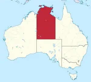 Location of Northern Territory in Australia | |||||||||||||||
| Coordinates: 20°S 133°E | |||||||||||||||
| Country | |||||||||||||||
| Established by NSW | 1825 | ||||||||||||||
| Transferred to South Australia | 1862 | ||||||||||||||
| Transferred to Commonwealth | 1911 | ||||||||||||||
| Dissolved | 1927 | ||||||||||||||
| Reformed | 1931 | ||||||||||||||
| Responsible government | 1978 | ||||||||||||||
| Capital | Darwin | ||||||||||||||
| Largest city | Darwin | ||||||||||||||
| Government | |||||||||||||||
| • Type | Constitutional monarchy | ||||||||||||||
| • Body | Northern Territory Government | ||||||||||||||
| • Administrator | Vicki O'Halloran | ||||||||||||||
| • Chief Minister | Michael Gunner (ALP) | ||||||||||||||
| Legislature | Parliament of the Northern Territory Legislative Assembly (25 seats) | ||||||||||||||
| Judiciary | |||||||||||||||
| Federal representation | Parliament of Australia
| ||||||||||||||
| Area | |||||||||||||||
| • Total | 1,420,970 km2 (548,640 sq mi) | ||||||||||||||
| • Land | 1,349,129 km2 (520,902 sq mi) | ||||||||||||||
| • Water | 71,839 km2 (27,737 sq mi) | ||||||||||||||
| Area rank | 3rd | ||||||||||||||
| Highest elevation | 1,531 m (5,023 ft) | ||||||||||||||
| Population (June 2020)[1] | |||||||||||||||
| • Total | 245,980 | ||||||||||||||
| • Rank | 8th | ||||||||||||||
| • Density | 0.17/km2 (0.45/sq mi) | ||||||||||||||
| • Density rank | 8th | ||||||||||||||
| Demonym(s) | Northern Territorian, Territorian | ||||||||||||||
| Time zone | UTC+9:30 (ACST) | ||||||||||||||
| Postal code | NT | ||||||||||||||
| ISO 3166 code | AU-NT | ||||||||||||||
| GSP year | 2019–20 | ||||||||||||||
| GSP (A$ million) | $26,153[2] (8th) | ||||||||||||||
| GSP per capita | $106,851 (2nd) | ||||||||||||||
| Website | www | ||||||||||||||
| |||||||||||||||

The NT covers 1,349,129 square kilometres (520,902 sq mi), making it the third-largest Australian federal division, and the 11th-largest country subdivision in the world. It is sparsely populated, with a population of only 245,980,[1] fewer than half as many people as Tasmania.[1]
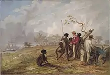
The archaeological history of the Northern Territory may have begun over 60,000 years ago when humans first settled this region of the Sahul Continent. Reportedly the Makassan traders began a relationship with the indigenous people of the Northern Territory around the trading of trepang from at least the 18th century. The coast of the territory was first seen by Europeans in the 17th century.[6] The British were the first Europeans to attempt to settle the coastal regions. After three failed attempts to establish a settlement (1824–28, 1838–49, and 1864–66), success was achieved in 1869 with the establishment of a settlement at Port Darwin.
The economy is based largely on mining and petroleum, which during 2018–2019 contributed 23% of the gross state product, or $5.68 billion, accounting for 92.4% of exports.[7][8]
The capital and largest city is Darwin. The population is concentrated in coastal regions and along the Stuart Highway. The other major settlements are (in order of size) Palmerston, Alice Springs, Katherine, Nhulunbuy and Tennant Creek. Residents of the Northern Territory are often known simply as "Territorians" and fully as "Northern Territorians", or more informally as "Top Enders" and "Centralians".
History
Humans have lived in the present area of the Northern Territory since at least 48.4 to 68.7 thousand years ago [9] and for at least the last five centuries of that time, extensive seasonal trade links are said to have existed between the Indigenous peoples of this area and what is now Indonesia.
With the coming of the British, there were four early attempts to settle the harsh environment of the northern coast, of which three failed in starvation and despair. The land now occupied by the Northern Territory was part of colonial New South Wales from 1825 to 1863, except for a brief time from February to December 1846, when it was part of the short-lived colony of North Australia. The Northern Territory was part of South Australia from 1863 to 1911. Under the administration of colonial South Australia, the overland telegraph was constructed between 1870 and 1872.
From its establishment in 1869 the Port of Darwin was the major Territory supply for many decades.
A railway was built between Palmerston and Pine Creek between 1883 and 1889. The economic pattern of cattle raising and mining was established so that by 1911 there were 513,000 cattle. Victoria River Downs was at one time the largest cattle station in the world. Gold was found at Grove Hill in 1872 and at Pine Creek, Brocks Creek, Burundi, and copper was found at Daly River.
On 1 January 1911, a decade after federation, the Northern Territory, alongside the Australian Capital Territory, was separated from South Australia and transferred to federal control. Alfred Deakin opined at this time "To me the question has been not so much commercial as national, first, second, third and last. Either we must accomplish the peopling of the northern territory or submit to its transfer to some other nation."[10]
In late 1912 there was growing sentiment that the name "Northern Territory" was unsatisfactory.[11][12] The names "Kingsland" (after King George V and to correspond with Queensland), "Centralia" and "Territoria" were proposed with Kingsland becoming the preferred choice in 1913. However, the name change never went ahead.[13][14]
For a brief time between 1927 and 1931 the Northern Territory was divided into North Australia and Central Australia at the 20th parallel of South latitude. Soon after this time, parts of the Northern Territory were considered in the Kimberley Plan as a possible site for the establishment of a Jewish Homeland, understandably considered the "Unpromised Land".[15][16]
During World War II, most of the Top End was placed under military government. This is the only time since Federation that part of an Australian state or territory has been under military control. After the war, control for the entire area was handed back to the Commonwealth. The Bombing of Darwin occurred on 19 February 1942. It was the largest single attack ever mounted by a foreign power on Australia. Evidence of Darwin's World War II history is found at a variety of preserved sites in and around the city, including ammunition bunkers, airstrips, oil tunnels and museums. The port was damaged in the 1942 Japanese air raids. It was subsequently restored.
In the late 1960s improved roads in adjoining States linking with the territory, port delays and rapid economic development led to uncertainty in port and regional infrastructure development. As a result of the Commission of Enquiry established by the Administrator,[17] port working arrangements were changed, berth investment deferred and a port masterplan prepared.[18] Extension of rail transport was then not considered because of low freight volumes.
Indigenous Australians had struggled for rights to fair wages and land. An important event in this struggle was the strike and walk off by the Gurindji people at Wave Hill Cattle Station in 1966. The Northern Territory Council for Aboriginal Rights (NTCAR) supported the strikers and provided publicity.[19] The federal government of Gough Whitlam set up the Woodward Royal Commission in February 1973, which set to enquire into how land rights might be achieved in the Northern Territory. Justice Woodward's first report in July 1973 recommended that a Central Land Council and a Northern Land Council be established to present to him the views of Aboriginal people. In response to the report of the Royal Commission a Land Rights Bill was drafted, but the Whitlam Government was dismissed before it was passed.
The Aboriginal Land Rights (Northern Territory) Act 1976 was eventually passed by the Fraser government on 16 December 1976 and began operation on 26 January 1977).
In 1974, from Christmas Eve to Christmas Day, Darwin was devastated by tropical Cyclone Tracy. Cyclone Tracy killed 71 people, caused A$837 million in damage (approximately A$6.85 billion in 2018),[20] and destroyed more than 70 per cent of Darwin's buildings, including 80 per cent of houses. Tracy left more than 41,000 out of the 47,000 inhabitants of the city homeless. The city was rebuilt with much-improved construction codes and is a modern, landscaped metropolis today.
The Northern Territory Council for Aboriginal Rights was disestablished in 1976.[19]
In 1978 the territory was granted responsible government, with a Legislative Assembly headed by a chief minister. The territory also publishes official notices in its own Government Gazette. The administrator of the Northern Territory is an official acting as the Queen's indirect representative in the territory.
During 1995–96 the Northern Territory was briefly one of the few places in the world with legal voluntary euthanasia, until the Federal Parliament overturned the legislation.[21] Before the over-riding legislation was enacted, four people used the law supported by Dr. Philip Nitschke.
Geography
There are many very small settlements scattered across the territory, but the larger population centres are located on the single paved road that links Darwin to southern Australia, the Stuart Highway, known to locals simply as "the track".
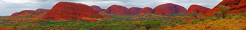
The Northern Territory is home to two spectacular natural rock formations, Uluru (Ayers Rock) and Kata Tjuta (The Olgas), which are sacred to the local Aboriginal peoples and which have become major tourist attractions.
The northern portion of the territory is principally tropical savannas, composed of several distinct ecoregions – Arnhem Land tropical savanna, Carpentaria tropical savanna, Kimberley tropical savanna, Victoria Plains tropical savanna, and Mitchell Grass Downs. The southern portion of the territory is covered in deserts and xeric shrublands, including the Great Sandy-Tanami desert, Simpson Desert, and Central Ranges xeric scrub.
In the northern part of the territory lies Kakadu National Park, which features extensive wetlands and native wildlife. To the north of that lies the Arafura Sea, and to the east lies Arnhem Land, whose regional centre is Maningrida on the Liverpool River delta. There is an extensive series of river systems in the Northern Territory. These rivers include: the Alligator Rivers, Daly River, Finke River, McArthur River, Roper River, Todd River and Victoria River. The Hay River is a river south-west of Alice Springs, with the Marshall River, Arthur Creek, Camel Creek and Bore Creek flowing into it.[23]
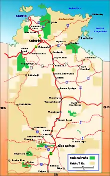
National parks
- Arnhem Land (Restricted Area)
- Barranyi (North Island) National Park
- Casuarina Coastal Reserve
- Daly River Nature Park
- Karlu Karlu / Devils Marbles Conservation Reserve
- Djukbinj National Park
- Dulcie Range National Park
- Elsey National Park
- Finke Gorge National Park
- Gregory National Park
- Gurig National Park-now Garig Gunak Barlu National Park
- Howard Springs Nature Park Conservation Reserve
- Iytwelepenty / Davenport Ranges National Park
- Kakadu National Park
- Karlu Karlu / Devils Marbles Conservation Reserve
- Keep River National Park
- Litchfield National Park
- Mary River Crossing Conservation Reserve and proposed Mary River National Park
- Mataranka Hot Springs
- Nitmiluk National Park
- Katherine Gorge
- Palm Valley
- Tanami Desert
- The Olgas
- Uluṟu-Kata Tjuṯa National Park
- Watarrka National Park (including Kings Canyon)
- West MacDonnell National Park
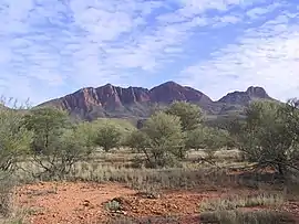 Mount Sonder, the fourth-highest mountain in the Northern Territory after nearby Mount Zeil, in West MacDonnell National Park
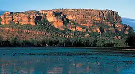
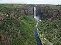 Jim Jim Falls, Kakadu National Park
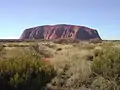 Uluru (Ayers Rock), one of the best-known images of the Northern Territory
 Aerial view of Uluru
Climate
| Average monthly maximum temperature in Northern Territory | ||||
| Month | Darwin | Alice Springs | ||
|---|---|---|---|---|
| January | 31.8 °C | 36.3 °C | ||
| February | 31.4 °C | 35.1 °C | ||
| March | 31.9 °C | 32.7 °C | ||
| April | 32.7 °C | 28.2 °C | ||
| May | 32.0 °C | 23.0 °C | ||
| June | 30.6 °C | 19.8 °C | ||
| July | 30.5 °C | 19.7 °C | ||
| August | 31.3 °C | 22.6 °C | ||
| September | 32.5 °C | 27.1 °C | ||
| October | 33.2 °C | 30.9 °C | ||
| November | 33.2 °C | 33.7 °C | ||
| December | 32.6 °C | 35.4 °C | ||
| Source: Bureau of Meteorology | ||||
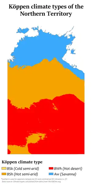
The Northern Territory has two distinctive climate zones.
The northern end, including Darwin, has a tropical climate with high humidity and two seasons, the wet (October to April) and dry season (May to September). During the dry season nearly every day is warm and sunny, and afternoon humidity averages around 30%. There is very little rainfall between May and September. In the coolest months of June and July, the daily minimum temperature may dip as low as 14 °C (57 °F), but very rarely lower, and frost has never been recorded.
The wet season is associated with tropical cyclones and monsoon rains. The majority of rainfall occurs between December and March (the southern hemisphere summer), when thunderstorms are common and afternoon relative humidity averages over 70% during the wettest months. On average more than 1,570 mm (62 in) of rain falls in the north. Rainfall is highest in north-west coastal areas, where rainfall averages from 1,800 to 2,100 mm (71 to 83 in).
The central region is the desert centre of the country, which includes Alice Springs and Uluru (Ayers Rock), and is semi-arid with little rain usually falling during the hottest months from October to March. Seasons are more distinct in central Australia, with very hot summers and cool winters. Frost is recorded a few times a year. The region receives less than 250 mm (9.8 in) of rain per year.
The highest temperature recorded in the territory was 48.3 °C (118.9 °F) at Finke on 1 and 2 January 1960. The lowest temperature was −7.5 °C (18.5 °F) at Alice Springs on 17 July 1976.[24]
| Climate data for Northern Territory | |||||||||||||
|---|---|---|---|---|---|---|---|---|---|---|---|---|---|
| Month | Jan | Feb | Mar | Apr | May | Jun | Jul | Aug | Sep | Oct | Nov | Dec | Year |
| Record high °C (°F) | 48.3 (118.9) |
46.4 (115.5) |
45.0 (113.0) |
41.5 (106.7) |
40.2 (104.4) |
37.9 (100.2) |
37.5 (99.5) |
39.7 (103.5) |
42.0 (107.6) |
45.0 (113.0) |
46.1 (115.0) |
47.2 (117.0) |
48.3 (118.9) |
| Record low °C (°F) | 6.7 (44.1) |
8.5 (47.3) |
4.7 (40.5) |
1.0 (33.8) |
−4.2 (24.4) |
−6.0 (21.2) |
−7.5 (18.5) |
−5.4 (22.3) |
−2.8 (27.0) |
0.0 (32.0) |
3.5 (38.3) |
7.5 (45.5) |
−7.5 (18.5) |
| Source: Bureau of Meteorology[25] | |||||||||||||
Governance

Parliament
The Northern Territory Parliament is one of the three unicameral parliaments in the country. Based on the Westminster System, it consists of the Northern Territory Legislative Assembly which was created in 1974, replacing the Northern Territory Legislative Council. It also produces the Northern Territory of Australia Government Gazette.
The Northern Territory Legislative Council was the partly elected governing body from 1947 until its replacement by the fully elected Northern Territory Legislative Assembly in 1974. The total enrolment for the 1947 election was 4,443. The Northern Territory was split into five electorates: Darwin, Alice Springs, Tennant Creek, Batchelor, and Stuart.
While this assembly exercises powers similar to those of the parliaments of the states of Australia, it does so by legislated devolution of powers from the Commonwealth Government, rather than by any constitutional right. As such, the Commonwealth Government retains the right to legislate for the territory, including the power to override legislation passed by the Legislative Assembly. The Monarch is represented by the Administrator of the Northern Territory, who performs a role similar to that of a state governor.
Twenty-five members of the Legislative Assembly are elected to four-year terms from single-member electorates.
For some years there has been agitation for full statehood. A referendum of voters in the Northern Territory was held on the issue in 1998, which resulted in a 'no' vote. This was a shock to both the Northern Territory and Commonwealth governments, as opinion polls showed most Territorians supported statehood. But under the Australian Constitution, the federal government may set the terms of entry to full statehood. The Northern Territory was offered three senators, rather than the twelve guaranteed to original states. (Because of the difference in populations, equal numbers of Senate seats would mean a Territorian's vote for a senator would have been worth more than 30 votes in New South Wales or Victoria.) Alongside what was cited as an arrogant approach adopted by then chief minister Shane Stone, it is believed that most Territorians, regardless of their general views on statehood, were reluctant to adopt the particular offer that was made.[26]
Chief minister and cabinet
The chief minister is the head of government of a self-governing territory (the head of a state government is a premier). The chief minister is appointed by the administrator, who in normal circumstances appoints the leader of whichever party holds the majority of seats in the Northern Territory Legislative Assembly. The current chief minister is Michael Gunner of the Australian Labor Party. He replaced Adam Giles on 31 August 2016.
Administrator
The Northern Territory became self-governing on 1 July 1978 under its own administrator appointed by the Governor-General of Australia. The federal government, not the NT government, advises the governor-general on the appointment of the administrator, but by convention consults first with the Territory government. The current administrator is Vicki O'Halloran.
Federal government

The Northern Territory is represented in the federal parliament by two members in the House of Representatives and two members in the Senate. As of May 2019, resulting from the 2019 federal election, Warren Snowdon from the Australian Labor Party (ALP) and Luke Gosling from the Australian Labor Party (ALP) serve in the House of Representatives, and Malarndirri McCarthy from the ALP and Sam McMahon from the Country Liberal Party serve in the Senate.
Local government
The Northern Territory is divided into 17 local government areas, including 11 shires and five municipalities. Shire, city and town councils are responsible for functions delegated by the Northern Territory parliament, such as road infrastructure and waste management. Council revenue comes mostly from property taxes and government grants.
Aboriginal land councils
Aboriginal land councils in the Northern Territory are groups of Aboriginal landowners, set up under the Aboriginal Land Rights Act 1976.
Political parties
The two historically dominant political parties in the Northern Territory are the conservative Country Liberal Party, and the social-democratic Australian Labor Party. Minor parties that are also active in the NT include the Northern Territory Greens, the Shooters and Fishers Party, Territory Alliance and various others. It is common for independent politicians to win election.
Demographics
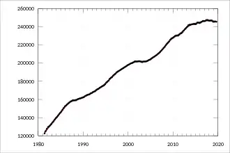
| Year | Population |
|---|---|
| 1901 | 4,765 |
| 1956 | 19,556 |
| 1961 | 44,481 |
| 1974 | 102,924 |
| 1976 | 97,090 |
| 1981 | 122,616 |
| 1991 | 165,493 |
| 1996 | 181,843 |
| 2002 | 200,019 |
| 2006 | 192,900 |
| 2011 | 211,945 |
| 2016 | 228,833 |
| Source: Australian Bureau of Statistics (Est Resident Pop) | |
The population of the Northern Territory at the 2011 Australian census was 211,945,[27] a 10 per cent increase from the 2006 census. The Australian Bureau of Statistics estimated a June 2015 resident population of 244,300, taking into account residents overseas or interstate. The territory's population represents 1% of the total population of Australia.[28][29][30]

The Northern Territory's population is the youngest in Australia and has the largest proportion (23.2%) under 15 years of age and the smallest proportion (5.7%) aged 65 and over. The median age of residents of the Northern Territory is 31 years, six years younger than the national median age.[27]
.jpg.webp)
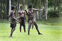
Indigenous Australians own some 49% of the land. The life expectancy of Aboriginal Australians is well below that of non-Indigenous Australians in the Northern Territory, a fact that is mirrored elsewhere in Australia. ABS statistics suggest that Indigenous Australians die about 11 years earlier than the average non-Indigenous Australian. There are Aboriginal communities in many parts of the territory, the largest ones being the Pitjantjatjara near Uluru, the Arrernte near Alice Springs, the Luritja between those two, the Warlpiri further north, and the Yolngu in eastern Arnhem Land.
More than 54% of Territorians live in Darwin, located in the territory's north (Top End). Less than half of the territory's population live in the rural Northern Territory. Despite this, the Northern Territory is the least urbanised federal division in the Commonwealth (followed by Tasmania).
Cities and towns
Not all communities are incorporated cities, or towns. They are referred to as "Statistical Local Areas."
| Rank | Statistical Local Areas | 2011 Population[31] |
|---|---|---|
| 1 | Darwin | 78,925 |
| 2 | Palmerston-East Arm | 30,098 |
| 3 | Alice Springs | 28,449 |
| 4 | Litchfield | 20,039 |
| 5 | Katherine | 10,355 |
| 6 | Nhulunbuy | 4,383 |
| 7 | Tennant Creek | 3,515 |
| 8 | Wadeye/Victoria-Daly | 2,682 |
| 9 | Jabiru | 1,271 |
| 10 | Yulara | 991 |
Ancestry and immigration
| Birthplace[N 1] | Population |
|---|---|
| Australia | 157,531 |
| Philippines | 5,914 |
| England | 5,583 |
| New Zealand | 4,636 |
| India | 3,598 |
| Greece | 1,268 |
| United States | 1,211 |
| Mainland China | 1,192 |
| Nepal | 1,126 |
| Indonesia | 1,117 |
| Ireland | 1,026 |
| East Timor | 1,024 |
At the 2016 census, the most commonly nominated ancestries were:[N 2][32][33]
31.2% of the population was born overseas at the 2016 census. The five largest groups of overseas-born were from the Philippines (2.6%), England (2.4%), New Zealand (2%), India (1.6%) and Greece (0.6%).[32][33]
25.5% of the population, or 58,248 people, identified as Indigenous Australians (Aboriginal Australians and Torres Strait Islanders) in 2016.[N 5][32][33]

Languages
At the 2016 census, 58% of the population spoke only English at home. The other languages most commonly spoken at home were Kriol (1.9%), Djambarrpuyngu (1.9%), Greek (1.4%) Tagalog (1.3%), and Warlpiri (0.9%).[32][33]
There are more than 100 Aboriginal languages and dialects spoken in the Northern Territory,[35] in addition to English which is most common in cities such as Darwin or Alice Springs. Major indigenous languages spoken in the Northern Territory include Murrinh-patha and Ngangikurrungurr in the northwest around Wadeye, Warlpiri and Warumungu in the centre around Tennant Creek, Arrernte around Alice Springs, Pintupi-Luritja to the south east, Pitjantjatjara in the south near Uluru, Yolngu Matha to the far north in Arnhem Land (where the dialect Djambarrpuyngu of Dhuwal is considered a lingua franca), and Burarra, Maung, Iwaidja and Kunwinjku in the centre north and on Croker Island and the Goulburn Islands. Tiwi is spoken on Melville Island and Bathurst Island.[36] Literature in many of these languages is available in the Living Archive of Aboriginal Languages.
Religion
In the 2016 census Roman Catholics form the single largest religious group in the territory with 19.9% of the Northern Territory's population, followed by Anglican (8.4%), Uniting Church (5.7%) and Lutheran (2.6%). Buddhism is the territory's largest non-Christian religion (2.0%), followed by Hinduism (1.6%), which is the fastest growing religion population percentage wise in the state. Australian Aboriginal religion and mythology (1.4%) is also practiced. Around 30% of Territorians do not profess any religion.[37]
Many Aborigines practise their traditional religion, their belief in the Dreamtime.
Education
Primary and secondary
A Northern Territory school education consists of six years of primary schooling, including one transition year, three years of middle schooling, and three years of secondary schooling. In the beginning of 2007, the Northern Territory introduced Middle School for Years 7–9 and High School for Years 10–12. Northern Territory children generally begin school at age five. On completing secondary school, students earn the Northern Territory Certificate of Education (NTCE). Students who successfully complete their secondary education also receive a tertiary entrance ranking, or ATAR score, to determine university admittance.
Northern Territory schools are either publicly or privately funded. Public schools, also known as state or government schools, are funded and run directly by the Department of Education.[38] Private fee-paying schools include schools run by the Catholic Church and independent schools, some elite ones similar to English public schools. Some Northern Territory Independent schools are affiliated with Protestant, Lutheran, Anglican, Greek Orthodox or Seventh-day Adventist Churches, but include non-church schools and an Indigenous school.
As of 2009, the Northern Territory had 151 public schools, 15 Catholic schools and 21 independent schools. 39,492 students were enrolled in schools around the territory with 29,175 in public schools, and 9,882 in independent schools. The Northern Territory has about 4,000 full-time teachers.
Tertiary
The Northern Territory has one university which opened in 1989 under the name of the Northern Territory University.[39] Now renamed as the Charles Darwin University, it had about 19,000 students enrolled: about 5,500 higher education students and about 13,500 students on vocational education and training (VET) courses. The first tertiary institution in the territory was the Batchelor Institute of Indigenous Tertiary Education which was established in the mid-1960s.
Libraries
The Northern Territory Library is the territory's research and reference library. It is responsible for collecting and preserving the Northern Territory documentary heritage and making it available through a range of programs and services. Material in the collection includes books, newspapers, magazines, journals, manuscripts, maps, pictures, objects, sound and video recordings and databases.
Economy
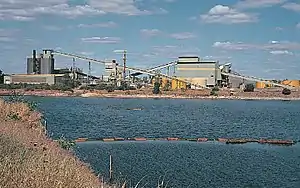
The Northern Territory's economy is largely driven by mining, which is concentrated on energy producing minerals, petroleum and energy and contributes around $2.5 billion to the gross state product and employs over 4,600 people. Mining accounts for 14.9% of the gross state product in 2014–15 compared to just 7% nationally.[40]
In recent years, largely due to the effect of major infrastructure projects and mine expansions, construction has overtaken mining as the largest single industry in the territory. Construction, mining and manufacturing, and government and community services, combine to account for about half of the territory's gross state product (GSP), compared to about a third of national gross domestic product (GDP).[41]
The economy has grown considerably over the past decade, from a value of $15 billion in 2004–05 to over $22 billion in 2014–15. In 2012–13 the territory economy expanded by 5.6%, over twice the level of national growth, and in 2014–15 it grew by 10.5%, four times the national growth rate.[42]
Between 2003 and 2006 the gross state product had risen from $8.67 billion to $11.476 billion and increase of 32.4%. During the three years to 2006–2007 the Northern Territory gross state product grew by an average annual rate of 5.5%. Gross state product per capita in the Northern Territory ($72,496) is higher than any Australian state or territory and is also higher than the gross domestic product per capita for Australia ($54,606).
The Northern Territory's exports were up 12.9% or $681 million in 2012–13. The largest contributor to the territory's exports was: mineral fuels (largely LNG), crude materials (mainly mineral ores) and food and live animals (primarily live cattle). The main international markets for territory exports are Japan, China, Indonesia, the United States and Korea.[43]
Imports to the Northern Territory totalled $2,887.8 million which consisted of mainly machinery and equipment manufacturing (58.4%) and petroleum, coal, chemical and associated product manufacturing (17.0%).[44]
The principal mining operations are bauxite at Gove Peninsula where the production is estimated to increase 52.1% to $254 million in 2007–08, manganese at Groote Eylandt, production is estimated to increase 10.5% to $1.1 billion which will be helped by the newly developed mines include Bootu Creek and Frances Creek, gold which is estimated to increase 21.7 per cent to $672 million at the Union Reefs plant and uranium at Ranger Uranium Mine.[45]
Tourism is an important economic driver for the territory and a significant industry in regional areas.[46] Iconic destinations such as Uluru and Kakadu make the Northern Territory a popular destination for domestic and international travellers. Diverse landscapes, waterfalls, wide open spaces, aboriginal culture and wild and untamed wildlife provides the opportunity for visitors to immerse themselves in the natural wonder that the Northern Territory offers. In 2015, the territory received a total of about 1.6 million domestic and international visitors contributing an estimated $2.0 billion to the local economy. Holiday visitors made up the majority of total visitation (about 792,000 visitors).
Tourism has strong links to other sectors in the economy including accommodation and food services, retail trade, recreation and culture, and transport.[46]
Transport
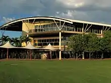
.JPG.webp)
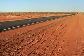
The Northern Territory is the most sparsely populated state or territory in Australia.
The NT has a connected network of sealed roads, including two National Highways, linking with adjoining States and connecting the major Territory population centres, and other important centres such as Uluru (Ayers Rock), Kakadu and Litchfield National Parks. The Stuart Highway, once known as "The Track", runs north to south, connecting Darwin and Alice Springs to Adelaide. Some of the sealed roads are single lane bitumen. Many unsealed (dirt) roads connect the more remote settlements.
The Adelaide–Darwin railway, a new standard gauge railway, connects Adelaide via Alice Springs with Darwin, replacing earlier narrow gauge railways which had a gap between Alice Springs and Birdum. The Ghan passenger train runs from Darwin to Adelaide, stopping at Katherine, Tennant Creek, Alice Springs and Kulgera in the NT.
The Northern Territory was one of the few remaining places in the world with no speed restrictions on select public roads, until 21 November 2016. On 1 January 2007 a default speed limit of 110 km/h was introduced on roads outside of urban areas (Inside urban areas of 40, 50 or 60 km/h). Speeds of up to 130 km/h are permitted on some major highways, such as the Stuart Highway.[47] On 1 February 2014, the speed limit was removed on a 204 km portion of the Stuart Highway for a one-year trial period.[48] The maximum speed limit was changed to 130 km/h on 21 November 2016.[49] Darwin International Airport is the major domestic and international airport for the territory. Several smaller airports are also scattered throughout the territory and are served by smaller airlines; including Alice Springs Airport, Ayers Rock Airport, Katherine Airport and Tennant Creek Airport.
Media
Print
The Northern Territory has only one daily tabloid newspaper, News Corporation's Northern Territory News, or NT News. The Sunday Territorian is the sister paper to the NT News and is the only dedicated Sunday tabloid newspaper in the Northern Territory.
The Centralian Advocate is circulated around the Alice Springs region twice a week. There are also five weekly community newspapers. The territory receives the national daily, The Australian, while The Sydney Morning Herald, The Age and the Guardian Weekly are also available in Darwin. Katherine's paper is the Katherine Times.
There is an LGBT community publication, QNews Magazine,[50] which is published in Darwin and Alice Springs.
Television
Metropolitan Darwin has had five broadcast television stations:
- ABC Northern Territory – (ABD)
- SBS Northern Territory – (SBS)
- Southern Cross Television – (TND) – Seven Network Affiliate
- Nine Network Darwin – (NTD)
- Ten Darwin (or Darwin Digital Television) – (DTD) – Network Ten Affiliate
Darwin also has a single open-narrowcast station:
- ITV64
Regional Northern Territory has a similar availability of stations:
- ABC Northern Territory – (ABD)
- SBS Northern Territory – (SBS)
- Southern Cross Central – (QQQ) – Seven Network Affiliate
- Imparja – (IMP) – Nine Network Affiliate
- Ten Central (or Central Digital Television) – (CDT) – Network Ten Affiliate
Remote areas are generally required to receive television via the Viewer Access Satellite Television service, which carries the same channels as the regional areas, as well as some extra open-narrowcast services, including Indigenous Community Television and Westlink.
Radio
Darwin has radio stations on both AM and FM frequencies. ABC stations include ABC NewsRadio (102.5FM), 105.7 ABC Darwin (8DDD 105.7FM), ABC Radio National (657AM), ABC Classic FM (107.3FM) and Triple J (103.3FM). The two commercial stations are Mix 104.9 (8MIX) and Hot 100 FM (8HOT).
The leading community stations are 104.1 Territory FM, and Radio Larrakia (8KNB).
The radio stations in Alice Springs are also broadcast on the AM and FM frequencies. ABC stations include Triple J (94.9FM), ABC Classic FM (97.9FM), 783 ABC Alice Springs (783AM) and ABC Radio National (99.7FM). There are two community stations in the town—CAAMA (100.5FM) and 8CCC (102.1FM). The commercial stations, which are both owned by the same company are Sun 96.9 (96.9FM) and 8HA (900AM). Two additional stations, Territory FM (98.7FM) and Radio TAB (95.9FM) are syndicated from Darwin and Brisbane, respectively.
Sport
See also
- Australian Aboriginal prehistoric sites
- Crime in the Northern Territory
- Index of Australia-related articles
- Juvenile detention in the Northern Territory
- Northern Territory Police
- List of highways in the Northern Territory
- Category:Cities in the Northern Territory
- Category:Towns in the Northern Territory
Notes
- In accordance with the Australian Bureau of Statistics source, England, Scotland, Mainland China and the Special Administrative Regions of Hong Kong and Macau are listed separately
- As a percentage of 199,426 persons who nominated their ancestry at the 2016 census.
- The Australian Bureau of Statistics has stated that most who nominate "Australian" as their ancestry are part of the Anglo-Celtic group.[34]
- Of any ancestry. Includes those identifying as Aboriginal Australians or Torres Strait Islanders. Indigenous identification is separate to the ancestry question on the Australian Census and persons identifying as Aboriginal or Torres Strait Islander may identify any ancestry.
- Of any ancestry. Includes those identifying as Aboriginal Australians or Torres Strait Islanders. Indigenous identification is separate to the ancestry question on the Australian Census and persons identifying as Aboriginal or Torres Strait Islander may identify any ancestry.
References
Citations
- "National, state and territory population – June 2020". Australian Bureau of Statistics. 17 December 2020. Retrieved 17 December 2020.
- "5220.0 – Australian National Accounts: State Accounts, 2019–20". Australian Bureau of Statistics. 20 November 2020. Retrieved 20 January 2021.
- "Floral Emblem of the Northern Territory". Anbg.gov.auhi. Retrieved 26 March 2008.
- "Northern Territory". Parliament.curriculum.edu.au. Retrieved 22 January 2013.
- "Northern Territory Acceptance Act 1910".
6(1). The Northern Territory is by this Act declared to be accepted by the Commonwealth as a Territory under the authority of the Commonwealth, by the name of the Northern Territory of Australia.
- "Did the Spanish land in Australia before James Cook? | National Library of Australia". www.nla.gov.au. Retrieved 14 August 2020.
- "Industries". Northen Territory Economy. Department of Treasury and Finance, Northern Territory Government. 2019. Retrieved 31 August 2020.
- "International trade". Northern Territory Economy. Department of Treasury and Finance, Northern Territory Government. 2019. Retrieved 31 August 2020.
- Clarkson, Chris; Jacobs, Zenobia; Marwick, Ben; Fullagar, Richard; Wallis, Lynley; Smith, Mike; Roberts, Richard G.; Hayes, Elspeth; Lowe, Kelsey; Carah, Xavier; Florin, S. Anna; McNeil, Jessica; Cox, Delyth; Arnold, Lee J.; Hua, Quan; Huntley, Jillian; Brand, Helen E. A.; Manne, Tiina; Fairbairn, Andrew; Shulmeister, James; Lyle, Lindsey; Salinas, Makiah; Page, Mara; Connell, Kate; Park, Gayoung; Norman, Kasih; Murphy, Tessa; Pardoe, Colin (2017). "Human occupation of northern Australia by 65,000 years ago" (PDF). Nature. Springer Nature. 547 (7663): 306–310. Bibcode:2017Natur.547..306C. doi:10.1038/nature22968. hdl:2440/107043. ISSN 0028-0836. PMID 28726833.
- Walker, David (1999). Anxious Nation: Australia and the Rise of Asia, 1850–1939. University of Queensland Press. p. 122. ISBN 978-0702231315.
- "The Territory: Federal Policy Criticised". The Advertiser. 14 November 1912.
- "House of Representatives". Sydney Morning Herald. 14 November 1912.
- "Territoria or Kingsland!". The Register. 16 April 1914.
- "Kingsland: New name for the Northern Territory". The Advertiser. 22 April 1913.
- "Wasted Years". The Sydney Morning Herald (34, 577). New South Wales, Australia. 16 October 1948. p. 6. Retrieved 20 July 2019 – via National Library of Australia.
- "Immigration Scheme That Failed". The Advertiser (Adelaide). 91 (28178). South Australia. 29 January 1949. p. 8. Retrieved 20 July 2019 – via National Library of Australia.
- Australia, ed. (30 April 1977). Darwin and Northern Territory freight transport study. Australian Government Publishing Service. ISBN 9780642033512. Retrieved 30 April 2019 – via National Library of Australia (new catalog).
- "Northern Territory Council for Aboriginal Rights". National Museum of Australia. 26 November 2018. Retrieved 30 November 2020.
- Reserve Bank of Australia (30 October 2015). "Inflation Calculator". Retrieved 19 July 2019.
- "Select Committee on Euthanasia". Legislative Assembly of the Northern Territory. 13 September 2007. Archived from the original on 2 March 2011.
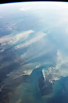
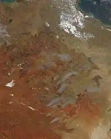
- "Fires around Darwin, Australia August 21, 2013". Earthobservatory.nasa.gov. 21 August 2013. Retrieved 17 July 2016.
- "Hay River". Bonzle.com. Retrieved 10 June 2019.
- "Rainfall and Temperature Records: National" (PDF). Bureau of Meteorology. Retrieved 17 November 2009.
- "Daily Extremes". Bureau of Meteorology. Retrieved 5 December 2020.
- ABC Lateline Discussion (Current Affairs). Australia: Australian Broadcasting Corporation. 15 October 1998. Archived from the original on 19 May 2006. Retrieved 10 February 2007.
- 2011 Census QuickStats: Northern Territory, Australian Bureau of Statistics, 9 August 2011.
- "3101.0 – Australian Demographic Statistics, Mar 2016". Australian Bureau of Statistics. 22 September 2016. Retrieved 1 November 2016.
- "3218.0 - Regional Population Growth, Australia, 2014-15, Northern Territory". Australian Bureau of Statistics. 29 March 2016. Archived from the original on 10 March 2017. Retrieved 29 August 2016.
- "3101.0 – Australian Demographic Statistics, Dec 2011". Australian Bureau of Statistics. 25 June 2012. Archived from the original on 29 August 2012.
- "3218.0 – Regional Population Growth, Australia, 2011". Australian Bureau of Statistics. 31 July 2012. Retrieved 29 August 2016.
- "2016 Census Community Profiles: Northern Territory". quickstats.censusdata.abs.gov.au.
- http://www.censusdata.abs.gov.au/CensusOutput/copsub2016.NSF/All%20docs%20by%20catNo/2016~Community%20Profile~7/$File/GCP_7.zip?OpenElement
- Statistics, c=AU; o=Commonwealth of Australia; ou=Australian Bureau of (January 1995). "Feature Article - Ethnic and Cultural Diversity in Australia (Feature Article)". www.abs.gov.au.
- "Archived copy". Archived from the original on 30 January 2016. Retrieved 23 January 2016.CS1 maint: archived copy as title (link)
- "Archived copy" (PDF). Archived from the original (PDF) on 30 January 2016. Retrieved 23 January 2016.CS1 maint: archived copy as title (link)
- "Profile .id, Community Profile - Regional NT". Profile.id.com.au. Retrieved 21 June 2018.
- "About us". 11 February 2015.
- "Celebrating 25 Years of University Education in the Northern Territory". Retrieved 24 March 2015.
- "About Minerals and Energy Department of Regional Development, Primary Industry, Fisheries and Resources". Nt.gov.au. 16 September 2011. Archived from the original on 23 May 2013. Retrieved 23 January 2013.
- "Archived copy" (PDF). Archived from the original (PDF) on 24 February 2017. Retrieved 16 February 2017.CS1 maint: archived copy as title (link)
- "Archived copy" (PDF). Archived from the original (PDF) on 24 February 2017. Retrieved 16 February 2017.CS1 maint: archived copy as title (link)
- "Archived copy". Archived from the original on 21 March 2017. Retrieved 1 January 2019.CS1 maint: archived copy as title (link)
- "Northern Territory Economics". Australian Bureau of Statistics. 31 October 2007. Retrieved 27 July 2008.
- "Northern Territory Budget Mining and energy" (PDF). Archived from the original (PDF) on 20 July 2008. Retrieved 29 January 2017.
- "Australian Economy Profiles - by REMPLAN". Economyprofile.com.au. Retrieved 30 April 2019.
- "Northern Territory Introduces Speed Limits". CarAdvice.com.au. 4 November 2006.
- "Open Speed Trial – drive to conditions". Northern Territory Department of Transport. 19 June 2014. Archived from the original on 14 July 2014. Retrieved 5 July 2014.
- "Subscribe to the NT News". Ntnews.com.au. Retrieved 30 April 2019.
- "About Us". Qnews.com.au. Retrieved 30 April 2019.
Sources
- Hill, Ernestine. 1951. The Territory: The classic saga of Australia's far north. Angus & Robertson. Reprint: 1995. ISBN 0-207-18821-1
- Govan, A. (2007) Broadband debate key to NT's future. N.T. Business Review, vol. N/A, no. N/A, p. 7
- Morrison, P. (2000) a pilot implementation of internet access for remote aboriginal communities in the "Top end" Of Australia. Urban Studies, Vol. 37, No.10, pp. 1781–1792.
- Toyne, P. (2002) Northern Territory Government's Response to the House of Representatives Communications, Information Technology & the Arts Committee inquiry into Wireless Broadband Communications. In N.T. GOVERNMENT (Ed.) (pp. 3). Darwin: Northern Territory Government.
- Toyne, P. (2003) Remote Areas Telecommunications Strategy 2003–2008. In N. T. GOVERNMENT (Ed.) (pp. 1– 32). Darwin N.T. viewed 6 February 2008, <Wayback Machine>
External links
| Wikimedia Commons has media related to Northern Territory. |
| Wikivoyage has a travel guide for Northern Territory. |
- Northern Territory Government of Australia
- Northern Territory Visitor's Guide
- Australian Bureau of Statistics (27 April 2007). "Northern Territory at a Glance, 2007" (PDF 855 kB).
 Geographic data related to Northern Territory at OpenStreetMap
- Northern Territory Weather and Warnings Summary from the Bureau of Meteorology
- Northern-Territory Northern Territory Climate
- Northern Territory economy/mining
- Northern Territory Universities
- Northern Territory Population estimates June 2007
- June 2007 NT population estimates
- NT Street and Place Names search
| Topics | ||
|---|---|---|
| Regions | ||
| Major settlements | ||
| States | 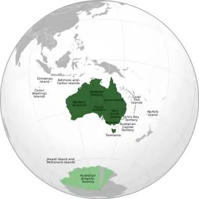 | ||||||||
|---|---|---|---|---|---|---|---|---|---|
| Territories |
| ||||||||
(1) Sovereignty recognised only by New Zealand, United Kingdom, France, and Norway. (2) Co-mandate with New Zealand and United Kingdom. | |||||||||
| Authority control |
|---|