Ohio State Route 159
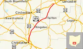
State Route 159 (SR 159) is a northeast-southwest state highway (signed north–south) in the south-central portion of the U.S. state of Ohio. Its southern terminus is in Chillicothe at the U.S. Route 50 and State Route 104 concurrency; its northern terminus is at U.S. Route 22 approximately 4 miles (6.4 km) southeast Lancaster.
| ||||
|---|---|---|---|---|
 | ||||
| Route information | ||||
| Maintained by ODOT | ||||
| Length | 30.91 mi[1] (49.74 km) | |||
| Existed | 1923[2][3]–present | |||
| Major junctions | ||||
| South end | ||||
| North end | ||||
| Location | ||||
| Counties | Ross, Pickaway, Fairfield | |||
| Highway system | ||||
| ||||

History
SR 159 was original signed in 1923, on much of its current alignment.[2][3] In 1927 the route was extended south to US 23, along the alignment of former State Route 27.[4][5] The first section of road paved was in 1933 and it was a section from the southern terminus to Meade.[6][7] In 1935 the second section was paved between Meade and Tarlton.[8][9] The final section of the roadway was paved between Tarlton and the northern terminus, in 1938.[10][11] The route was extended north to its current terminus along the former alignment of U.S. Route 22, in 1971.[12][13] In 1972 the highway was extended south to its current terminus along the former alignment of U.S. Route 23.[13][14]
A construction project in Ross County added two roundabouts at a new intersection with SR 207 and the intersection of SR 180. Construction began in October 2019 and was completed the following October.[15][16][17]
Major intersections
| County | Location | mi[1] | km | Destinations | Notes |
|---|---|---|---|---|---|
| Ross | Chillicothe | 0.00 | 0.00 | Southern end of US 23 Business concurrency | |
| 1.01 | 1.63 | Interchange | |||
| Springfield Township | 3.73 | 6.00 | Northern end of US 23 Business concurrency and northern terminus of US 23 Business; interchange | ||
| Green Township | 6.0 | 9.7 | Eastern terminus of SR 207; Roundabout | ||
| 6.52 | 10.49 | Western terminus of SR 180; Roundabout | |||
| Pickaway | Pickaway Township | 11.10 | 17.86 | Southern terminus of SR 361 | |
| Salt Creek Township | 16.30 | 26.23 | |||
| Fairfield | Hocking Township | 30.91 | 49.74 | ||
1.000 mi = 1.609 km; 1.000 km = 0.621 mi
| |||||
References
- Ohio Department of Transportation. "Technical Services Straight Line Diagrams". Retrieved August 18, 2013.
- Official Ohio Highway Map (Map). Cartography by ODOH. Ohio Department of Highways. 1922. Retrieved February 21, 2013.
- Official Ohio Highway Map (Map). Cartography by ODOH. Ohio Department of Highways. 1923. Retrieved February 21, 2013.
- Official Ohio Highway Map (Map). Cartography by ODOH. Ohio Department of Highways. 1926. Retrieved February 21, 2013.
- Official Ohio Highway Map (Map). Cartography by ODOH. Ohio Department of Highways. 1927. Retrieved February 21, 2013.
- Official Ohio Highway Map (Map). Cartography by ODOH. Ohio Department of Highways. 1932. Retrieved February 21, 2013.
- Official Ohio Highway Map (Map). Cartography by ODOH. Ohio Department of Highways. 1933. Retrieved February 21, 2013.
- Official Ohio Highway Map (Map). Cartography by ODOH. Ohio Department of Highways. 1934. Retrieved February 21, 2013.
- Official Ohio Highway Map (Map). Cartography by ODOH. Ohio Department of Highways. 1935. Retrieved February 21, 2013.
- Official Ohio Highway Map (Map). Cartography by ODOH. Ohio Department of Highways. 1937. Retrieved February 21, 2013.
- Official Ohio Highway Map (Map). Cartography by ODOH. Ohio Department of Highways. 1938. Retrieved February 21, 2013.
- Official Ohio Highway Map (Map). Cartography by ODOH. Ohio Department of Highways. 1969. Retrieved February 21, 2013.
- Official Ohio Highway Map (Map). Cartography by ODOH. Ohio Department of Highways. 1971. Retrieved February 21, 2013.
- Official Ohio Highway Map (Map). Cartography by ODOH. Ohio Department of Highways. 1972. Retrieved February 21, 2013.
- "Ross-207 Extension". Ohio Department of Transportation. Retrieved February 25, 2020.
- Barnhart, Toria (October 25, 2019). "Construction begins on Ross-207 extension, roundabout project". Chillicothe Gazette. Retrieved February 25, 2020.
- "State Route 207 Connector opens in Ross County". Ohio Department of Transportation. October 8, 2020. Retrieved December 19, 2020.