Ohio State Route 218
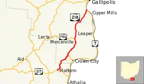
State Route 218 (SR 218) is a north–south state highway in the southern portion of the U.S. state of Ohio. The southern terminus of State Route 218 is at a T-intersection with State Route 217 approximately 5 miles (8.0 km) northwest of Athalia. Its northern terminus is at a T-intersection with State Route 7 about 2 miles (3.2 km) south of Gallipolis.
| ||||
|---|---|---|---|---|
 | ||||
| Route information | ||||
| Maintained by ODOT | ||||
| Length | 19.51 mi[1] (31.40 km) | |||
| Existed | 1924–present | |||
| Major junctions | ||||
| South end | ||||
| North end | ||||
| Location | ||||
| Counties | Lawrence, Gallia | |||
| Highway system | ||||
| ||||

Route description
State Route 218 travels through portions of Lawrence and Gallia. There are no segments of this state route that are incorporated within the National Highway System.[2]
History
When it was first established in 1924, State Route 218 consisted of the entirety of the current routing of State Route 553 from State Route 7 in Crown City northwesterly to its junction with State Route 218, and the current alignment of State Route 218 from the State Route 553 intersection northeasterly to its current northern terminus at State Route 7 south of Gallipolis.[3][4] Two years later, the southern end of the highway was re-aligned. From its current junction with State Route 553, State Route 218 was routed southwesterly along a previously un-numbered roadway to what is now State Route 218's southern terminus at State Route 217.[5][6]
Major intersections
| County | Location | mi[1] | km | Destinations | Notes |
|---|---|---|---|---|---|
| Lawrence | Rome Township | 0.00 | 0.00 | ||
| Gallia | Guyan Township | 6.25 | 10.06 | Western terminus of SR 553 | |
| 10.91 | 17.56 | Eastern terminus of SR 790 | |||
| Gallipolis Township | 19.51 | 31.40 | |||
| 1.000 mi = 1.609 km; 1.000 km = 0.621 mi | |||||
References
- Ohio Department of Transportation. "Technical Services Straight Line Diagrams". Retrieved 2010-12-05.
- National Highway System: Ohio (PDF) (Map). Federal Highway Administration. December 2003. Retrieved 2010-12-05.
- Ohio State Map (Map). Ohio Department of Transportation. 1923.
- Ohio State Map (Map). Ohio Department of Transportation. 1924.
- Ohio State Map (Map). Ohio Department of Transportation. 1925.
- Ohio State Map (Map). Ohio Department of Transportation. 1926.