Ohio State Route 379
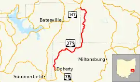
State Route 379 (SR 379, OH 379) is a north–south state highway located in the southeastern quadrant of the U.S. state of Ohio. The highway runs from its southern terminus at a T-intersection with State Route 78 nearly 3.25 miles (5.23 km) northeast of Summerfield to its northern terminus at a Y-intersection with State Route 147 about 3.75 miles (6.04 km) northeast of Batesville on the Noble-Belmont County Line.
| ||||
|---|---|---|---|---|
 | ||||
| Route information | ||||
| Maintained by ODOT | ||||
| Length | 14.73 mi[1] (23.71 km) | |||
| Existed | 1935[2][3]–present | |||
| Major junctions | ||||
| South end | ||||
| North end | ||||
| Location | ||||
| Counties | Monroe, Belmont | |||
| Highway system | ||||
| ||||

Route description
Along its path, State Route 379 passes through northwestern Monroe County and southwestern Belmont County. This state highway is not included as a part of the National Highway System, a system of routes identified as being most important for the economy, mobility and defense of the nation.[4]
History
The State Route 379 designation was assigned in 1935. Originally, the highway was a spur route, running along its current alignment from its present northern terminus at State Route 147 southwesterly to the northwestern Monroe County hamlet of Calais.[2][3] Two years later, State Route 379 was extended to the southwest from Calais to end at its present southern terminus at State Route 78.[5][6]
Major intersections
| County | Location | mi[1] | km | Destinations | Notes |
|---|---|---|---|---|---|
| Monroe | Seneca Township | 0.00 | 0.00 | ||
| Belmont–Noble county line | Somerset–Beaver township line | 14.73 | 23.71 | ||
| 1.000 mi = 1.609 km; 1.000 km = 0.621 mi | |||||
References
- Ohio Department of Transportation. "Technical Services Straight Line Diagrams". Retrieved 2011-02-05.
- Map of Ohio Showing State Highway System (MrSID) (Map). Cartography by ODOH. Ohio Department of Highways. 1934. Retrieved 2011-02-05.
- Map of Ohio Showing State Highway System (MrSID) (Map). Cartography by ODOH. Ohio Department of Highways. 1935. Retrieved 2011-02-05.
- National Highway System: Ohio (PDF) (Map). Federal Highway Administration. December 2003. Retrieved 2011-02-05.
- Official Ohio Highway Map (MrSID) (Map). Cartography by ODOH. Ohio Department of Highways. 1936. Retrieved 2011-02-05.
- Official Ohio Highway Map (MrSID) (Map). Cartography by ODOH. Ohio Department of Highways. 1937. Retrieved 2011-02-05.