Ohio State Route 586
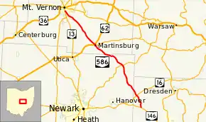
State Route 586 (SR 586) is a north–south state highway located in the central portion of the U.S. state of Ohio. The highway's southern terminus is at a T-intersection with SR 146 in the unincorporated community of Nashport. The highway's northern terminus is at a Y-intersection with SR 13 in Mount Vernon.
| ||||
|---|---|---|---|---|
 | ||||
| Route information | ||||
| Maintained by ODOT | ||||
| Length | 29.98 mi[1] (48.25 km) | |||
| Existed | 1939[2][3]–present | |||
| Major junctions | ||||
| South end | ||||
| North end | ||||
| Location | ||||
| Counties | Muskingum, Licking, Knox | |||
| Highway system | ||||
| ||||

Route description
Along its way, SR 586 travels through northwestern Muskingum County, northeastern Licking County and southeastern Knox County. No portion of this highway is included as a component of the National Highway System, a network of routes identified as most important for the nation's economy, mobility and defense.[4]
History
SR 586 was designated in 1939. It was established along the routing between SR 146 in Nashport and SR 13 in Mount Vernon that it utilizes today. No changes of major significance have taken place to the highway since its designation.[2][3]
Major intersections
| County | Location | mi[1] | km | Destinations | Notes |
|---|---|---|---|---|---|
| Muskingum | Licking Township | 0.00 | 0.00 | ||
| Jackson Township | 3.11 | 5.01 | Interchange | ||
| Licking | Fallsbury Township | 10.99 | 17.69 | ||
| Knox | Martinsburg | 19.26 | 31.00 | Southern end of US 62 concurrency; western terminus of SR 541 | |
| 19.39 | 31.21 | Northern end of US 62 concurrency | |||
| Mount Vernon | 29.98 | 48.25 | |||
1.000 mi = 1.609 km; 1.000 km = 0.621 mi
| |||||
References
- Ohio Department of Transportation. "Technical Services Straight Line Diagrams". Retrieved 2010-10-01.
- Official Ohio Highway Map (MrSID) (Map). Cartography by ODOH. Ohio Department of Highways. 1938. Retrieved 2011-01-27.
- Ohio Highway Map (MrSID) (Map). Cartography by ODOH. Ohio Department of Highways. 1939. Retrieved 2011-01-27.
- National Highway System: Ohio (PDF) (Map). Federal Highway Administration. December 2003. Retrieved 2011-01-27.