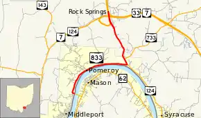
Ohio State Route 833
State Route 833 (SR 833) is a 5.10-mile (8.21 km) long east–west state highway in the southern portion of the U.S. state of Ohio. Its western terminus is at the West Virginia state line in Pomeroy, where it provides a connection to West Virginia Route 62 (WV 62) via the Pomeroy-Mason Bridge across the Ohio River. Its eastern terminus is at an interchange with U.S. Route 33, SR 7, and SR 124 approximately 2 miles (3.2 km) north of Pomeroy.
| ||||
|---|---|---|---|---|
 | ||||
| Route information | ||||
| Maintained by ODOT | ||||
| Length | 5.10 mi[1] (8.21 km) | |||
| Existed | 2003–present | |||
| Major junctions | ||||
| West end | ||||
| East end | ||||
| Location | ||||
| Counties | Meigs | |||
| Highway system | ||||
| ||||
Established in 2003, SR 833 follows the former alignment of US 33, which was given a new, more direct route into West Virginia through Ravenswood, West Virginia and on Interstate 77 (I-77) in West Virginia. The West Virginia portion of decertified U.S. Route 33 was replaced by extending WV 62 to Ripley, West Virginia.
Route description
SR 833 exists entirely within the southern part of Meigs County. This state highway is not included within the National Highway System (NHS). The NHS is a network of routes identified as being most important for the nation's economy, mobility and defense.[2]
History
When US 33 was re-routed through Meigs County in 2003 along SR 7, then easterly onto a new alignment onto the Ravenswood Bridge across the Ohio River into Ravenswood, West Virginia and a more direct connection with I-77, the former routing of US 33, running from the connection with WV 62 at the Pomeroy-Mason Bridge, through Pomeroy, and concurrently with SR 124 to the US 33/SR 7 interchange north of Pomeroy was given the designation of SR 833.
Major intersections
The entire route is in Meigs County.
| Location | mi[1][3] | km | Destinations | Notes | |
|---|---|---|---|---|---|
| Pomeroy | 0.00 | 0.00 | West Virginia state line on Pomeroy-Mason Bridge | ||
| 2.84 | 4.57 | Southern end of SR 124 concurrency | |||
| 3.08 | 4.96 | Western terminus of SR 733 | |||
| Salisbury Township | 5.10 | 8.21 | Interchange; northern end of SR 124 concurrency | ||
1.000 mi = 1.609 km; 1.000 km = 0.621 mi
| |||||
References
- Ohio Department of Transportation. "Technical Services Straight Line Diagrams: SR 833, Meigs County" (PDF). Retrieved July 6, 2013.
- National Highway System: Ohio (PDF) (Map). Federal Highway Administration. December 2003. Retrieved June 5, 2011.
- "Journal Entry - State Route 733" (PDF). ODOT. 2013. Retrieved November 4, 2013.
Said addition shall begin at a point along S.R. 124 identified as Straight Line Mileage (SLM) point 22.19, said point being the intersection of S.R. 124, S.R. 833 and Chester Road, within the Village of Pomeroy
