Old Exe Bridge
The Old Exe Bridge is a ruined mediaeval bridge in Exeter in the south west of England. It was built around the year 1200 and originally consisted of 17 or 18 arches spanning the River Exe. Believed to be one of England's oldest surviving mediaeval bridge works, the remnants are a grade II listed building and scheduled monument.[1][2][3]
Old Exe Bridge | |
|---|---|
.JPG.webp) | |
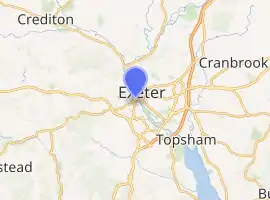
| Coordinates | 50.719111°N 3.535800°W |
| Crosses | River Exe (originally) |
| Locale | Exeter, Devon, England |
| Heritage status | Grade II listed building, scheduled monument |
| Characteristics | |
| Material | Stone |
| History | |
| Opened | c. 1200 |
| Closed | 1778 |
| Location | |
| |
History
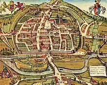
Exeter was founded as Isca Dumnoniorum by the Romans. There are records of a crossing of the River Exe from Roman times, probably a timber bridge. No trace of any timber bridge survives; it is likely that, once replaced, it was simply left to degrade.[1][4] The bridge was constructed between 1190 and 1210, having been promoted by Nicholas and Walter Gervase, father and son and prominent local residents. The Gervases were well-off merchants. Walter was subsequently elected mayor of Exeter several times and had his parents buried in the chapel on the Exe Bridge upon their deaths (the exact dates of which are unknown); he died in 1252. The exact dates of the bridge's construction are not known, but stone bridges often took two decades or more to complete in the Middle Ages. The Gervases may have been inspired by the Pont d'Avignon in France, or by London Bridge (which was under construction at around the same time), though multiple similar bridges were constructed across England in the same era.[1][5]
No records survive of the people responsible for the design and construction of the bridge. There is a record of a bridge chaplain in 1196, suggesting that the bridge was at least part-built by then. It was certainly complete by 1214, when St Edmund's Church was built on it. The bridge consisted of possibly 17 or 18 arches, though this figure is uncertain and some historians suggest there could have been as few as 12 arches, including supporting arches. It crossed the Exe diagonally and continued across the marshy banks which were prone to flooding.[2][1][6]
The bridge is known to have been repaired several times throughout its lifetime. The earliest repairs are impossible to date, but a partial collapse was recorded during a storm in 1286, and again in 1384, when several people were killed. It was rebuilt on both occasions. Later repairs can be dated by the stone used—they were made with Heavitree breccia, a local stone not quarried until the mid 14th century (approximately 150 years after the bridge was built). By 1447, the bridge was recorded as being severely dilapidated and the mayor, John Shillingford, appealed for funds to rebuild it but the process was interrupted by his sudden death the following year. In 1539, one of the central arches collapsed and was promptly repaired using stone from St Nicholas' Priory but there was still no refurbishment of the whole structure. An Act of Parliament in 1773 empowered the trustees to repair or rebuild the bridge but events overtook the planned repairs when, in December 1775, a fire broke out in the Fortune of War, a public house (pub) built on the bridge. The fire consumed the pub and neighbouring house. The pub provided cheap accommodation to local vagrants and it was believed that upwards of 30 people may have been inside at the time of the fire; at least nine bodies were recovered after the fire was extinguished.[7]
Repairs and maintenance of the bridge were provided for from the proceeds of land bought by the Gervases at the time the bridge was built, and the funds were administered by bridge wardens. The wardens were responsible for the upkeep of the bridge until 1769, when the responsibility was passed to the Exeter turnpike trust by Act of Parliament. The trust was dissolved in 1884 and responsibility for the bridge and its estate passed to Exeter City Council.[8]
The spans across the river were demolished following the completion of a new, three-arch masonry bridge in 1778, but the arches on the Exeter bank were left intact and eventually buried or incorporated into buildings. The 18th-century bridge was itself demolished and replaced with a steel bridge in 1905, built by Sir John Wolfe Barry, who was also responsible for London's Tower Bridge. Barry's bridge was itself replaced by a pair of reinforced concrete bridges, which opened in 1969 and 1972.[8] Parts of the mediaeval bridge were exposed by German bombing during the Second World War. More arches were revealed during the construction of the modern bridges..[9] The engineers were careful to site the new bridges away from the line of the mediaeval bridge, and during the work an old brewery and several adjoining buildings (part of the reclaimed land and backing onto the river) were demolished and the street was abandoned. The demolition uncovered five of the mediaeval arches and, after further excavation, another three and a half arches were exposed. The area around the arches was landscaped into a public park by Exeter City Council.[10][11] The bases of several of the demolished arches survive on the riverbed and about 25 metres (82 ft) of bridge is buried under Edmund Street and the modern bank of the Exe.[2][1]
Architecture
Slightly less than half of the bridge's original length survives. Of the surviving eight-and-a-half arches, most are semi-circular, but two are pointed though all were apparently part of the same build and all were built with ribbed vaults. The visible arches vary in span from 3.7 metres (12 feet) to 5.7 metres (19 feet). Two of them form the crypt of the bridge chapel, St Edmund's Church. It spanned the river diagonally in a north-westerly direction from what is now Exeter city centre to St Thomas (now a suburb of Exeter but originally outside the city), terminating outside St Thomas' Church, which was built at around the same time. The bridge was 5 metres (16 feet) wide on average, allowing for a 4-metre-wide roadway between the parapets. The parapets are lost but some of the mediaeval paving survives, along with other, later, paving. Timber-framed houses were built with their front walls resting on the parapets of the bridge and the rest of the building supported by wooden posts in the river.[1][6]
The surviving arches are up to 6 metres high. The piers are rounded in the downstream direction but feature cutwaters (streamlined brickwork intended to reduce the impact of the water on the piers) facing upstream. Local stone was used for the faces of the arches, behind which is gravel and rubble contained within a box of wooden stakes which were driven into the ground and the riverbed. Dendrochronology (tree-ring dating) has established that the oldest of these stakes came from trees felled between 1190 and 1210.[1] The surviving arches are a mix of Norman-style semi-circles and the pointed Gothic style, though it is unknown whether the mix was part of the original design or the result of later repairs.[12]
In the later 13th century, silty deposits had built up on the Exeter side of the bridge, allowing the land to be reclaimed for two buildings which backed onto the river and fronted onto what is now Frog Street. Archaeological evidence suggests that one of the two was possibly a leather tannery. The houses were demolished in the post-mediaeval era but the foundations survived.[1]
Buildings
A church was built onto the bridge, supported by two of the bridge arches, and dedicated to St Edmund the Martyr. It was approximately 20 metres (66 feet) long and 5.5 metres (18 feet) with an entrance on the bridge and possibly a second entrance underneath. The first record of a bridge chaplain is from 1196, suggesting that the church may have already been built by that date. A record of the completed church exists from 1214, when it was mentioned in a list of churches in Exeter, along with St Thomas' Church. It had a rectangular plan, 54 feet (16 metres) long by 16 feet 6 inches (5 metres) wide. Its south wall rested on the north side (right-hand side when crossing from the Exeter side) of the bridge and its side walls rested on the cutwaters while the north wall was supported by piers rising from the riverbed which had their own cutwaters.[6]
The church was extended several times during the bridge's lifetime. By the end of the 14th century, accumulated silt on the Exeter side allowed a portion of land to be reclaimed and leaving the west wall of the church above dry land. This allowed the bridge to be extended, and the north wall was partially demolished to allow an aisle to be added, adding 7 feet (2.1 metres) to the width of the church. Work on a bell tower began in 1449 after Edmund Lacey, the Bishop of Exeter, offered indulgences in exchange for financial contributions. Further extensions followed in the 16th century, by which time the area of land reclaimed from the river had grown, and several of the bridge arch buildings were now on dry land. Several buildings were constructed next to the bridge on the Exeter bank, protected from the river by a wall which extended from the west side of the church. The church was severely damaged in a fire in 1882 and was largely rebuilt the following year, though retaining much of the ancient stonework. It was partially demolished in 1975, when most of the later additions were removed but the mediaeval stonework was preserved. Although ruined, the tower survives at its original height—the only intact part of the church.[1][13][14]
On the opposite side of the bridge was a smaller chantry chapel (a chapel employing a priest to pray for a given period of time after a person's death, to aid that person's passage to heaven), built in the 1250s for Walter Gervase and dedicated to the Blessed Virgin Mary. Upon his death in 1252, Gervase was buried in the chapel (later joined by his wife) and left an endowment of 50 shillings a year for a priest to hold three services a week. The chapel continued in use until at least 1537 but was destroyed in 1546 as a result of the Dissolution of the Monasteries. Only stone fragments from the foundations survive.[1][15]
References
| Wikimedia Commons has media related to Medieval bridge, Exeter. |
Bibliography
- Brierley, J. (February 1979). "The Mediaeval Exe Bridge". Proceedings of the Institution of Civil Engineers. London: Institution of Civil Engineers. 66 (1): 127–139. doi:10.1680/iicep.1979.2269. ISSN 1753-7789.
- Cook, Martin (1998). Medieval Bridges. Princes Risborough, Buckinghamshire: Shire Books. ISBN 9780747803843.
- Otter, R. A. (1994). Civil Engineering Heritage: Southern England. London: Thomas Telford. ISBN 9780727719713.
- Pevsner, Nikolaus; Cherry, Bridget (2002). Devon. The Buildings of England. New Haven, Connecticut: Yale University Press. ISBN 9780300095968.
Citations
- Historic England. "The medieval Exe Bridge, St Edmund's Church, and medieval tenement remains, lying between the River Exe and Frog Street (1020671)". National Heritage List for England. Retrieved 2 January 2018.
- Historic England. "Old Exe Bridge (1103988)". National Heritage List for England. Retrieved 2 January 2018.
- "About Exe Bridge, Exeter". Transport Trust. Retrieved 8 January 2019.
- Brierley. p. 127.
- Brierley. p. 130.
- Brierley. p. 131.
- Brierley, pp. 135–136.
- Brierley, p. 136.
- Pevsner, p. 410.
- Brierley, pp. 136–137.
- Otter, pp. 72–73.
- Brierley, pp. 137–138.
- Brierley, p. 133.
- Pevsner, p. 390.
- Brierley, p. 135.