Omolon
The Omolon (Russian: Омолон) is the principal tributary of the Kolyma in northeast Siberia. The length of the river is 1,114 kilometres (692 mi). The area of its basin is 113,000 square kilometres (44,000 sq mi).[1] The Omolon freezes up in October and stays under ice until late May through early June. The lower 600 kilometres (370 mi) are navigable.
| Omolon | |
|---|---|
| Location | |
| Country | Russia |
| Physical characteristics | |
| Source | |
| • coordinates | 62.7186°N 157.5191°E |
| Mouth | Kolyma |
• coordinates | 68.7042°N 158.6972°E |
| Length | 1,114 km (692 mi) |
| Basin size | 113,000 km2 (44,000 sq mi) |
| Basin features | |
| Progression | Kolyma→ East Siberian Sea |
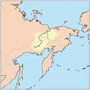
It begins in the Kolyma Highlands, Magadan Oblast, less than 100 kilometres (62 mi) from the Sea of Okhotsk, flows north, forms part of the border of Magdan and Chukotka, crosses Chukota, briefly enters the Sakha Republic and joins the Kolyma 282 kilometres (175 mi) upstream from the Arctic. Its basin is surrounded by: (west) branches of the Kolyma, (south) Penzhina and others that flow south, (east) Anadyr and (northeast) Bolshoy Anyuy. The upper Omolon is subalpine in the highlands, the middle is boreal forest and the lower part tundra. There is a Zakaznik in Chukotka to protect the forests.
Its main tributaries are the Molongda, the west-flowing Oloy (at 471 kilometres (293 mi), the largest tributary), Oloychan, Kedon and Ango.[2]
References
- Река Омолон in the State Water Register of Russia (Russian)
- "Омолон" [Omolon]. Great Soviet Encyclopedia (in Russian) (3rd ed.). 1969–1978.
- Omolon river problems
- "Tourism and environment" (PDF). (571 KB)
- Meteorite found near the Omolon River