Omsk
Omsk (/ɒmsk/; Russian: Омск, IPA: [omsk]; Siberian Tatar: Qara-tora) is a city and the administrative center of Omsk Oblast, Russia, located in southwestern Siberia 2,236 kilometers (1,389 mi)[13] from Moscow. With a population of 1,154,116, it is Russia's third-largest city east of the Ural Mountains after Novosibirsk and Yekaterinburg, and seventh by size nationally.[6] Omsk acts as an essential transport node, serving as a train station for the Trans-Siberian Railway and as a staging post for the Irtysh River.
Omsk
Омск | |
|---|---|
City[1] | |
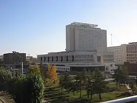
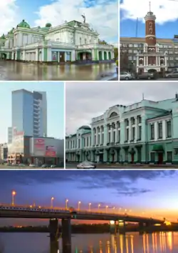 Top:Omsk State Academic Drama Theater, Fire Observation Tower, (left to right) Middle:Omsk Festiwal Complex Center area, Vrubel Fine Art Museum, (left to right) Bottom:60 years Victory Bridge (Most 60 Letiya Pobedy) | |
 Flag  Coat of arms | |
Location of Omsk 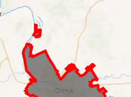
| |
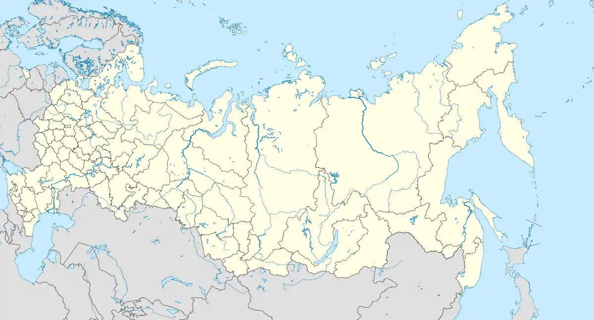 Omsk Location of Omsk 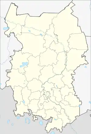 Omsk Omsk (Omsk Oblast) | |
| Coordinates: 54°59′N 73°22′E | |
| Country | Russia |
| Federal subject | Omsk Oblast[1] |
| Founded | August 2, 1716[2] |
| City status since | 1782[3] |
| Government | |
| • Body | City Council[4] |
| • Mayor[5] | Oksana Fadina[5] |
| Area | |
| • Total | 572.9 km2 (221.2 sq mi) |
| Elevation | 90 m (300 ft) |
| Population | |
| • Total | 1,154,116 |
| • Estimate (2018)[7] | 1,172,070 (+1.6%) |
| • Rank | 7th in 2010 |
| • Density | 2,000/km2 (5,200/sq mi) |
| • Subordinated to | city of oblast significance of Omsk[1] |
| • Capital of | Omsk Oblast[1], city of oblast significance of Omsk[1] |
| • Urban okrug | Omsk Urban Okrug[8] |
| • Capital of | Omsk Urban Okrug[8] |
| Time zone | UTC+6 (MSK+3 |
| Postal code(s)[10] | 644xxx |
| Dialing code(s) | +7 3812[11] |
| OKTMO ID | 52701000001 |
| City Day | First Saturday of August[12] |
| Website | www |
During the Imperial era, Omsk was the seat of the Governor General of Western Siberia and, later, of the Governor General of the Steppes. For a brief period during the Russian Civil War in 1918–1920, it served as the capital of the anti-Bolshevik Russian State and held the imperial gold reserves.
Omsk serves as the episcopal see of the bishop of Omsk and Tara, as well as the administrative seat of the Imam of Siberia. The mayor is Oksana Fadina.
History
The creation of the Omsk fortress, like other Upper Irtysh fortresses, was caused by the urgent need to strengthen the trade route to China. The merit for their arrangement belongs entirely to the Siberian governor, Prince M.P. Gagarin. However, he also bears a large share of the responsibility. Gagarin, being the governor in Nerchinsk, and then the head of the Siberian order and the Siberian province, devoted a lot of time and effort to trade with China. And above all, the organization of the trade route to this country. The main route passed from Tobolsk down the Irtysh, then up the Ob, then along the Ket portage to the Yenisei and further to the border with China. The journey was long, difficult, and expensive. There was also a second option - up the Irtysh, two times shorter and much easier. Kalmyk, Kyrgyz-Kaisak and Chinese chiefs were interested in this route as they all had their share of international trade. However, above the mouth of the Om, trade caravans were attacked by free detachments of Kalmyks (Oirats) and Kirghiz-Kaisaks, which their rulers could not cope with. A reliable guard was needed with its placement in stationary fortifications. One way or another, the Siberian governor achieved in May 1714 the tsar's consent to build fortresses along the Irtysh and further to the existing trade route: In his report to the tsar on May 22, 1714, Gagarin substantiated the need to build fortresses along the Irtysh by the need to ensure communication and safety of the expedition going to the city of Yarkand for the golden sand. The gold deposit was located behind the Tien Shan ridges, on the territory of a neighboring state, in the Taklamakan desert. Prince Gagarin understood the consequences of this adventure, which, with a positive result, threatened a military conflict with China and Dzungaria. Of course, the Siberian governor did not expect the military expedition to reach Yarkand. It was almost impossible and unnecessary. But the fortresses along the trade route would remain. And indeed, they stayed. The tsar believed the governor and signed a decree on organizing an expedition under the command of a former captain of the Guards, Army Lieutenant Colonel Ivan Bukholts and, accordingly, about the construction of fortresses along the Irtysh, above Yamyshev.[14][15][16]
on January 2, 1716, Matvey Petrovich Gagarin took up his governor's duties and again actively took up the construction of fortresses in Siberia, including on Lake Kosogol, on the Yenisei and Irtysh rivers. Between January 8 and 10, 1716, the prince meets with the king and makes an offering to him in the form of a golden collection from the ancient burial mounds plundered along the Ishim and Irtysh. At the meeting, Gagarin reported to Peter about his plans for the development of Siberia and received the tsar's permission, presumably in the form of the highest resolution. On January 27, 1716, Peter I left for Europe, where he stayed until October 1717 and stopped receiving timely and reliable information from Siberia. In January 1716, Gagarin (with reference to the tsar's decree) issued his own orders for the construction of a fortress on the frontier Kosogol lake and in April on the construction of fortresses on the Upper Yenisei.
On April 28, the Buholz detachment abandoned the Yamyshev fortress and moved down the Irtysh to the territory of the Tarsky district. Gagarin assessed the situation and gave instructions to Lieutenant Colonel Buholz and the Tara commandant about building a fortress at the mouth of the Om and sent recruits to reinforce them. By the end of 1716, the first fortress (fortified place) was built in the area of the modern river station. It consisted of an earthen pentagonal fortress, powder and food stores, barracks for soldiers, houses for officers. The first Omsk fortress (fortified place) was practically a copy of the fortress, erected in 1715 near Yamyshevskoye Lake. And, accordingly, it carried the main drawback: the fortifications were scattered, the outer fence was weak. When the enemy attacked, the entire garrison would have to defend the fortress objects separately from each other, which happened in 1716 during the defense of the Yamyshevskaya fortress. The unsuccessful layout of the first Yamyshev and Omsk fortresses was explained, first of all, by the lack of fortification experience among the construction managers.[17][18]
At the beginning of 1717, the dragoon captain Ilya Gavrilovich Aksakov was invited from Russia. The Governor confers a major on him and directs him to supervise the construction of a new (second) fortress at the mouth of the Om. In the summer of the same year, the Omsk garrison under the command of Stupin went to the upper Irtysh to build fortresses. Lieutenant Colonel Ivan Buholz categorically refused to lead a new expedition and in March 1717 was sent from Tobolsk to the capital. There is very little information about the foundation of the Omsk settlement and the construction of the second fortress. One of the most valuable sources of information is the inventory of documents of the Tara Chancellery, copied for Professor G.F. Miller in 1734. This inventory was mentioned by Professor V.I. Kochedamov in 1960, and in 2015 it was published by the Barnaul scientists V.B. Borodaev and A.V. Kontev.[19] However, there are no drawings and, accordingly, it is not known where and how the new city (fortress) should be built. From Tara to the Omsk fortress, a drawing was sent "On the structure of the Omsk fortress beyond the Omya river prison and courtyards in a line." In 1722 this drawing was used by the captain-engineer Paul de Grange in the development of the plan of the fortress on the right bank of the Om. At the end of the summer of 1717, Gagarin ordered the production of six bells for the Yamyshevskaya and Omsk fortresses. Bells were made by the military department and in an amount of three pieces per fortress. According to the drawing of the Omsk fortress in 1717, these are: a triangular guard redoubt at the mouth of the Om; a quadrangular fort at the crossing over the Om and a pentagonal fortress on the yar. At the beginning of 1718, seven bells were made. Perhaps the seventh was intended for the Omsk Sloboda, on the right bank of the Om. There is no information yet whether the quadrangular fort and the triangular redoubt were built. However, it is known for sure that the fortress (defensive structure) was built pentagonal, although not as regular in shape as in the drawing. This is evident from the plans of 1745 and 1755. At the same time, the entire settlement (Omsk fortress, including the Cossack settlement and the main defensive structure) had the shape of an irregular, broken quadrangle.[20]
In 1768 Om fortress was relocated. The original Tobolsk and the restored Tara gates, along with the original German Lutheran Church and several public buildings are left from that time. Omsk was granted town status in 1782.[21]
In 1822 Omsk became an administrative capital of Western Siberia and later in 1882 the center of the vast Steppes region (today the northern part of Kazakhstan) and Akmolinsk Oblast, in particular acquiring several churches and cathedrals of various denominations, mosques, a synagogue, the governor-general's mansion, and a military academy.[22] But as the frontier receded and its military importance diminished, the town fell into lethargy. For that time Omsk became a major center of the Siberian exile. From 1850 to 1854 Fyodor Dostoyevsky served his sentence in an Omsk katorga prison.
Inside the Omsk settlement (the city of Omsk), a military settlement - the Omsk fortress - lived its own life for about 150 years. By 1845, the structures of the Omsk fortress were half destroyed, which prompted the engineering department of the military department to petition for the abolition of the fortress. In 1864 the fortress was abolished.
Development of the city was catalyzed with the construction of the Trans-Siberian Railway in the 1890s that affected significance of Omsk as a logistic hub. Many trade companies established stores and offices in Omsk defining the character of the city center. British, Dutch, and German consulates were established roughly at the same time in order to represent their commercial interests. The pinnacle of development for pre-revolutionary Omsk was the Siberian Exposition of Agriculture and Industry in 1910. Popularity of the World Fairs contributed to the image of Omsk as the "Chicago of Siberia".[23]
Soon after the October Revolution, anti-Bolshevik White forces seized control of Omsk. The "Provisional All-Russian Government" was established here in 1918, headed by the Arctic explorer and decorated war hero Admiral Kolchak. Omsk was proclaimed the capital of Russia, and its central bank was tasked with safekeeping the former empire's gold reserves. These were guarded by a garrison of former Czechoslovakian POWs trapped in Siberia by the chaos of World War I and the subsequent Revolution. Omsk became a prime target for the Red Army leadership, which viewed it as a major target of their Siberian campaign and eventually forced Kolchak and his government to abandon the city and retreat along the Trans-Siberian eastward to Irkutsk. Bolshevik forces entered the city in 1919.
Soviet period
The Soviet government preferred the young Novonikolayevsk (later known as Novosibirsk) as the administrative center of Western Siberia, prompting the mass transfer of administrative, cultural, and educational functions from Omsk. This somewhat stunted Omsk's growth and sparked a continuing rivalry between the two cities.[24] Omsk received new life as a result of World War II. Because it was both far from the fighting and had a well-developed infrastructure, Omsk provided a perfect haven for much of the industry evacuated away from the frontlines in 1941. Additionally, contingency plans were made to transfer the provisional Soviet capital to Omsk in the event of a German victory during the Battle of Moscow (October 1941 to January 1942).[25] At the end of the war, Omsk remained a major industrial center, subsequently becoming a leader in Soviet military production.
Military industries which moved to Omsk included part of the OKMO tank-design bureau in 1941, and S.M. Kirov Factory no. 185 from Chelyabinsk, in 1962. The Kirov Factory and Omsk Transmash design bureau (KBTM) produced T-80 tanks from the 1970s, and were responsible for the BTR-T, TOS-1, and the prototype Black Eagle tank. Omsk Transmash declared bankruptcy in 2002.
In the 1950s, following the development of the oil and natural-gas field in Siberia, an oil-refining complex was built, along with an entire "town of oil workers", expanding Omsk northward along the Irtysh. It is currently the largest such complex in Russia. Gazprom Neft, the parent company, is the largest employer in the city, wielding its tax rates as leverage in negotiations with municipal and regional authorities.
Post-Soviet period
Following the dissolution of the Soviet Union, Omsk experienced a period of economic instability and political stagnation. Most of the city's large businesses, which had previously been state owned, were fought over by members of the former party elite, the emerging nouveau riche, and fast growing criminal syndicates. The most notorious cases involved the privatization of Sibneft, a major oil company, which dragged on for several years. Until the end of the 1990s, political life in Omsk was defined by an ongoing feud between the oblast and city authorities. The resulting conflict made at least two points of view available to the public and served as the impetus for some improvements to the city's infrastructure and cultural life. These included the construction of new leisure parks and the renovation of the city's historic center, the establishment of the annual Siberian International Marathon, and of the annual City Days Festival. Despite this, internal political competition drained the Omsk's resources and served as a major obstacle for smooth government operations and city development.
Geography
Location
Omsk is situated in the south of the West Siberian Plain along the banks of the north-flowing Irtysh at its confluence with the Om River. The city has an elevation of 87 meters (285 ft) above mean sea level at its highest point.
Omsk is an important railroad hub, and is the junction point for the northern and southern branches of the Trans-Siberian Railway. The city also serves as a major hub for the regional highway network. River-port facilities handle both passengers and freight, giving the city access to navigating the extensive waterways of the Irtysh and Ob River. The waterways connect Omsk with the coal and mineral-mining towns further up the river in Kazakhstan, as well as with the oil, natural gas and lumber operations of northern Siberia. Omsk is served by the Tsentralny Airport, which offers access to domestic and international (primarily, German and Kazakh) destinations, making the city an important aviation hub for Siberia and the Russian Far East.
It is about 450 km (280 mi) north of Kazakhstan's capital Nur-Sultan, and 600 km (370 mi) west of Siberia's largest city Novosibirsk.
Climate
Omsk has a humid continental climate Dfb characterized by dramatic swings of weather. Average daily temperatures, taken over the past three decades, are +20 °C (68 °F) for July and −17 °C (1 °F) for January, although temperatures can very rarely reach +40 °C (104 °F) in the summer and very rarely drop to −45 °C (−49 °F) in the winter. On average, Omsk sees over 300 sunny days a year (2201 hours). The average annual precipitation is 415 millimeters (16.3 in).
| Climate data for Omsk | |||||||||||||
|---|---|---|---|---|---|---|---|---|---|---|---|---|---|
| Month | Jan | Feb | Mar | Apr | May | Jun | Jul | Aug | Sep | Oct | Nov | Dec | Year |
| Record high °C (°F) | 4.2 (39.6) |
8.0 (46.4) |
14.1 (57.4) |
31.3 (88.3) |
35.5 (95.9) |
40.1 (104.2) |
40.4 (104.7) |
38.0 (100.4) |
32.9 (91.2) |
27.4 (81.3) |
16.1 (61.0) |
4.5 (40.1) |
40.4 (104.7) |
| Average high °C (°F) | −12 (10) |
−10.3 (13.5) |
−2.5 (27.5) |
9.1 (48.4) |
19.0 (66.2) |
23.9 (75.0) |
25.3 (77.5) |
22.7 (72.9) |
15.9 (60.6) |
8.1 (46.6) |
−3.7 (25.3) |
−9.8 (14.4) |
7.1 (44.8) |
| Daily mean °C (°F) | −16.3 (2.7) |
−15.0 (5.0) |
−7.3 (18.9) |
3.7 (38.7) |
12.5 (54.5) |
18.0 (64.4) |
19.6 (67.3) |
16.9 (62.4) |
10.4 (50.7) |
3.5 (38.3) |
−7.3 (18.9) |
−13.8 (7.2) |
2.1 (35.8) |
| Average low °C (°F) | −20.5 (−4.9) |
−19.4 (−2.9) |
−12 (10) |
−1.0 (30.2) |
6.3 (43.3) |
12.0 (53.6) |
14.2 (57.6) |
11.6 (52.9) |
5.7 (42.3) |
−0.3 (31.5) |
−10.5 (13.1) |
−17.9 (−0.2) |
−2.7 (27.1) |
| Record low °C (°F) | −45.1 (−49.2) |
−45.5 (−49.9) |
−41.1 (−42.0) |
−26.4 (−15.5) |
−12.9 (8.8) |
−3.1 (26.4) |
2.1 (35.8) |
−1.7 (28.9) |
−7.6 (18.3) |
−28.1 (−18.6) |
−41.2 (−42.2) |
−44.7 (−48.5) |
−45.5 (−49.9) |
| Average precipitation mm (inches) | 23 (0.9) |
18 (0.7) |
17 (0.7) |
21 (0.8) |
35 (1.4) |
51 (2.0) |
66 (2.6) |
54 (2.1) |
37 (1.5) |
30 (1.2) |
34 (1.3) |
29 (1.1) |
415 (16.3) |
| Average rainy days | 1 | 0.4 | 3 | 10 | 17 | 17 | 18 | 19 | 18 | 13 | 5 | 1 | 122 |
| Average snowy days | 28 | 25 | 18 | 9 | 2 | 0.2 | 0 | 0 | 1 | 11 | 22 | 28 | 144 |
| Average relative humidity (%) | 80 | 78 | 76 | 64 | 54 | 60 | 68 | 70 | 70 | 74 | 81 | 81 | 71 |
| Mean monthly sunshine hours | 68 | 125 | 184 | 235 | 284 | 319 | 321 | 248 | 180 | 105 | 71 | 61 | 2,201 |
| Source 1: Pogoda.ru.net[26] | |||||||||||||
| Source 2: NOAA (sun, 1961–1990)[27] | |||||||||||||
Administrative and municipal status
Within the framework of administrative divisions, it is incorporated as the city of oblast significance of Omsk—an administrative unit with the status equal to that of the districts.[1] As a municipal division, the city of oblast significance of Omsk is incorporated as Omsk Urban Okrug.[8]
Demographics
The population in Omsk had been steadily rising, according to the records: from 31,000 in 1881 to 53,050 in 1900 and to 1,148,418 in 1989.[28] The 2002 Census recorded that the population had declined to 1,134,016,[29] but it rebounded marginally, according to the 2010 Census, which listed the population of 1,154,116.[6]
Architecture
The architectural centerpiece of the city is an ensemble of buildings along Lyubinsky Avenue/Lenina Street, anchored by the former Gostiny Dvor, and flanked by two chapels. The area is an eclectic mix of architectural styles, dominated by Art-Nouveau, Neoclassical and Second Empire.
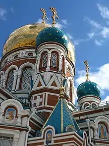
Closer to the confluence of the Om and the Irtysh are the few surviving sombre buildings of the 18th-century fortress. The largest and most opulent church in the city is the Dormition Cathedral, a five-domed edifice in the Russian Revival style, consecrated in 1896, demolished by the Soviets, and restored in the first decade of the 21st century.
Another area of interest is Nikolsky Avenue-Krasnykh Zor Street, where a line of merchants' wooden houses still stands. The street leads to the Neoclassical cathedral of St. Nicholas, which was commissioned by the Cossacks, designed by Vasily Stasov and consecrated in 1840. It contains various relics of the Siberian Cossacks.[30]
 Tarskaya Street
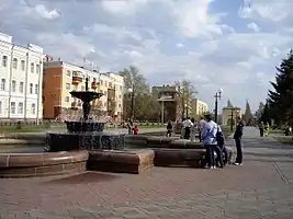
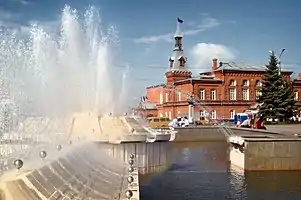 The fountain on Teatralnaya Ploshad'
Life and culture
As a prominent educational center, Omsk has a number of museums, theaters, music venues, and educational institutions.
Among Omsk's museums, the most notable are:
- The State Museum of Regional History
- The Dostoyevsky Museum of Literature[31]
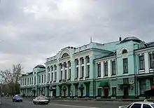
- The Vrubel Museum of Fine Arts[32]
- The Military Museum Complex
- The Kondraty Belov Art Museum
- The Liberov Center for Art
Theaters include the Omsk Opera, The Omsk Theater of Drama, The Omsk Circus, Omsk State Music Theater, and a number of smaller venues.
Education
Omsk is home to many institutions of higher learning and several universities:
- Law and Economics Institute
- Omsk Academy of Law
- Omsk Academy of MVD Rossija
- Omsk Aviation Technical School
- Omsk Foreign Language Institute
- Omsk State Medical University
- Omsk State Transport University (1961)
- Omsk State Agrarian University (1918) (connected with Omsk State Veterinary Institute and Institute of Agribusiness and Continuing Education)
- Omsk State Pedagogical University
- Omsk State University (1974)
- Omsk Institute of Consumer Service Technology
- Omsk State Technical University (1942)
- SibADI - (Russian: Сибирский АвтоДорожный Институт) Siberian State Automobile and Highway Academy (formerly, Institute)
- SibGUFK - (Russian: Сибирский Государственный Университет Физической Культуры) Siberian Academy of Physical Culture
- Siberian Institute of Business and Information Technology
- Sovremennyi Gomunitarnyi University
- SIBNFOR - Siberian Stock Market Institute
Sports
Omsk is represented nationally by professional association football and hockey clubs.
| Club | Sport | Founded | Current league | League rank | Stadium |
|---|---|---|---|---|---|
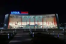
| Avangard Omsk | Ice Hockey | 1950 | Kontinental Hockey League | 1st | Omsk Arena |
| Omskie Yastreby | Ice Hockey | 2009 | Minor Hockey League | Jr. 1st | Omsk Arena |
| Yastreby Omsk | Ice Hockey | 2012 | Minor Hockey League Division B | Jr. 2nd | Omsk Arena |
| Omichka Omsk | Volleyball | 1965 | Woman's Volleyball Super League | 1st | Blinov SCC |
| Omichka-2 | Volleyball | 2009 | Woman's Supreme League | 2nd | SC Ermak |
| Irtysh Omsk | Football | 1946 | Russian Second Division | 2nd | Red Star Stadium |
| Neftyanik Omsk | Basketball | 1965 | Basketball Superleague B | 3rd | Sports Complex Sibirskiy Neftyanik |
Transportation
Omsk is a major rail, road, and air hub. The city is served by a station on the Trans-Siberian Railway, and by the Tsentralny Airport. Additionally, Omsk possesses a river port on the Irtysh, offering service to domestic destinations and to cities within Kazakhstan.
Municipal Transport consists of a large bus and trolley, and tram networks, although the latter of these has deteriorated severely since the collapse of the USSR. marshrutkas (shared taxis) supplement municipal transit networks.
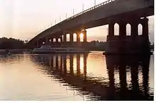
A Metro system, proposed in the late 1980s, but postponed for lack of funds, is currently under construction, with the Metro bridge over the Irtysh River. The bridge is already opened for cars (upper level), but the metro (lower level) is still under construction. As a first step, one short line will connect the districts in the northwest with the city center. As of 2017, only one station is open and serves as a pedestrian subway.
Honors
- The 3406 Omsk asteroid, which lies in the main asteroid belt, is named after the city.[33]
Notable people
- Eva Elfie, actress
- Innokenty Annensky, poet
- Nina Arkhipova, actress
- Vladislav Artemiev, chess player
- Fyodor Dostoyevsky, writer and essayist, in exile 1849–1854
- Vladislav Dvorzhetsky, actor
- Wacław Iwaszkiewicz-Rudoszański, Polish general
- Anatol Josepho, inventor
- Eduard Kunz, pianist
- Dmitry Yazov, Russian general
- Dmitry Karbyshev, general
- Vilis Krištopans, former Prime Minister of Latvia
- Valerian Kuybyshev, revolutionary
- Sergey Letov, jazz musician
- Yegor Letov, rock musician
- Vladimir Lukin, politician
- Leonid Martynov, poet
- Lyubov Polishchuk, actress
- Grigory Potanin, ethnographer and natural historian
- Ludmilla Radchenko, model and actress
- Vlada Roslyakova, model
- Robert Rozhdestvensky, poet
- Vissarion Shebalin, composer
- Valentina Talyzina, actress
- Mikhail Shivlyakov, Marine, Strongman
- Tamāra Vilerte, Latvian chess player
- Mikhail Vrubel, artist
- Mikhail Ulyanov, actor
- Nikolai Yadrintsev, explorer and archaeologist
Athletes
- Egor Averin, ice hockey player
- Vladimir Barnashov, biathlete and biathlon coach
- Vitalina Batsarashkina, sports shooter
- Vera Biryukova, rhythmic gymnast
- Viktor Blinov, ice hockey player
- Tatiana Borodulina, speed skater
- Ksenia Dudkina, rhythmic gymnast
- Dmitrij Jaskin, ice hockey player
- Sergei Kalinin, ice hockey player
- Yevgeniya Kanayeva, rhythmic gymnast
- Yuliya Kosenkova, middle-distance athlete
- Vera Krasnova, speed skater
- Marat Mulashev, professional football
- Nikita Nikitin, ice hockey player
- Nikita Pivtsakin, ice hockey player
- Anastasija Reiberger, pole vaulter
- Dennis Siver, mixed martial arts fighter
- Yuri Shatalov, ice hockey player
- Alexander Shlemenko, mixed martial arts fighter
- Galima Shugurova, rhythmic gymnast
- Sofya Skomorokh, rhythmic gymnast
- Roman Sloudnov, swimmer
- Alexander Svitov, ice hockey player
- Dmitri Sychev, association football player
- Andrei Taratukhin, ice hockey player
- Irina Tchachina, rhythmic gymnast
- Aleksei Tishchenko, boxer
- Polina Tsurskaya, figure skater
Twin towns – sister cities
See also
 Siberia portal
References
Notes
- Law #467-OZ
- GmbH, Emporis. "Omsk - Buildings - EMPORIS". www.emporis.com.
- "География Омска: географическое расположение города, районы, улицы в Омске". omsk.infomsk.ru.
- "Избирательное право. Официальный портал Администрации города Омска". www.admomsk.ru.
- "Mayor of Omsk: Curriculum Vitae". www.admomsk.ru.
- Russian Federal State Statistics Service (2011). "Всероссийская перепись населения 2010 года. Том 1" [2010 All-Russian Population Census, vol. 1]. Всероссийская перепись населения 2010 года [2010 All-Russia Population Census] (in Russian). Federal State Statistics Service.
- "26. Численность постоянного населения Российской Федерации по муниципальным образованиям на 1 января 2018 года". Federal State Statistics Service. Retrieved January 23, 2019.
- Law #548-OZ
- "Об исчислении времени". Официальный интернет-портал правовой информации (in Russian). June 3, 2011. Retrieved January 19, 2019.
- Почта России. Информационно-вычислительный центр ОАСУ РПО. (Russian Post). Поиск объектов почтовой связи (Postal Objects Search) (in Russian)
- "International Dialing Codes - how to call from Azerbaijan – Baku to Russia – Omsk – Omsk". www.timeanddate.com.
- "День города Омска. Официальный портал Администрации города Омска". www.admomsk.ru.
- "Distance between Moscow russia and Omsk russia". www.mapcrow.info.
- "1717 год. Омские крепость и слобода".
- Omsk history timeline (in Russian)
- "Исторические предпосылки основания Омской крепости".
- "Первый сибирский губернатор М. П. Гагарин и основание русской крепости на реке Омь" (PDF).
- Колесников А. Д. Основание Омской крепости и её роль в заселении Прииртышья // Известия Омского отделения Географического общества Союза ССР. Омск: Западно-Сибирское книжное издательство. Омское отделение, 1965. С. 133—135
- "Первый сибирский губернатор М. П. Гагарин и основание русской крепости на реке Омь" (PDF).
- "1717 год. Омские крепость и слобода".
- "History of the City of Omsk". www.admomsk.ru.
- Siberia and the Exile System ISBN 978-1-108-04823-1 p. 480
- "thinkrussia.com".
- "History of Omsk". kachaloff.narod.ru.
- Lecture 3:3: “World War II” – The Battle of Moscow, edb.gov.hk
- "Weather and Climate - The Climate of Omsk" (in Russian). Weather and Climate (Погода и климат). Retrieved November 30, 2015.
- "Omsk Climate Normals 1961–1990". National Oceanic and Atmospheric Administration. Retrieved November 30, 2015.
- "Всесоюзная перепись населения 1989 г. Численность наличного населения союзных и автономных республик, автономных областей и округов, краёв, областей, районов, городских поселений и сёл-райцентров" [All Union Population Census of 1989: Present Population of Union and Autonomous Republics, Autonomous Oblasts and Okrugs, Krais, Oblasts, Districts, Urban Settlements, and Villages Serving as District Administrative Centers]. Всесоюзная перепись населения 1989 года [All-Union Population Census of 1989] (in Russian). Институт демографии Национального исследовательского университета: Высшая школа экономики [Institute of Demography at the National Research University: Higher School of Economics]. 1989 – via Demoscope Weekly.
- Russian Federal State Statistics Service (May 21, 2004). "Численность населения России, субъектов Российской Федерации в составе федеральных округов, районов, городских поселений, сельских населённых пунктов – районных центров и сельских населённых пунктов с населением 3 тысячи и более человек" [Population of Russia, Its Federal Districts, Federal Subjects, Districts, Urban Localities, Rural Localities—Administrative Centers, and Rural Localities with Population of Over 3,000] (XLS). Всероссийская перепись населения 2002 года [All-Russia Population Census of 2002] (in Russian).
- Brumfield, William (September 27, 2011). "Omsk: Garrison city on the Irtysh".
- "litmuseum — Журнал о французской литературе и жизни во Франции". litmuseum.ru.
- "Музей имени М. А. Врубеля". www.vrubel.ru.
- "3406 Omsk 1969 - Поиск в Google". books.google.com.
- "Зарубежные города-партнеры Омска". admomsk.ru (in Russian). Omsk. Retrieved February 1, 2020.
Sources
- Законодательное Собрание Омской области. Закон №467-ОЗ от 15 октября 2003 г. «Об административно-территориальном устройстве Омской области и о порядке его изменения», в ред. Закона №1591-ОЗ от 10 декабря 2013 г. «О внесении изменений в отдельные Законы Омской области в связи с принятием Федерального Закона "Об образовании в Российской Федерации"». Вступил в силу через три месяца со дня официального опубликования. Опубликован: "Омский вестник", №69, 31 октября 2003 г. (Legislative Assembly of Omsk Oblast. Law #467-OZ of October 15, 2003 On the Administrative-Territorial Structure of Omsk Oblast and on the Procedures of Its Change, as amended by the Law #1591-OZ of December 10, 2013 On Amending Various Laws of Omsk Oblast Due to the Adoption of the Federal Law "On Education in the Russian Federation". Effective as of the day three months after the official publication date.).
- Законодательное Собрание Омской области. Закон №548-ОЗ от 30 июля 2004 г. «О границах и статусе муниципальных образований Омской области», в ред. Закона №1642-ОЗ от 27 июня 2014 г. «О внесении изменений в Закон Омской области "О границах и статусе муниципальных образований Омской области"». Вступил в силу со дня официального опубликования. Опубликован: "Омский вестник", №45, №47, №49, 13, 20, 27 августа 2004 г. (Legislative Assembly of Omsk Oblast. Law #548-OZ of July 30, 2004 On the Borders and Status of the Municipal Formations of Omsk Oblast, as amended by the Law #1642-OZ of June 27, 2014 On Amending the Law of Omsk Oblast "On the Borders and Status of the Municipal Formations of Omsk Oblast". Effective as of the day of the official publication.).
- Lugovskaya, Kseniya (September 6, 2014). "Warrior's 3,900 year old suit of bone armour unearthed in Omsk". The Siberian Times. Retrieved June 18, 2017.
Further reading
External links
| Wikivoyage has a travel guide for Omsk. |
| Wikimedia Commons has media related to Omsk. |
- Official website (in Russian)
- . Encyclopædia Britannica (11th ed.). 1911.
| Authority control |
|---|