Ophir Beach
Ophir Beach is an undeveloped sandy beach on the Oregon Coast seven miles north of Gold Beach in Curry County, United States.[1] It is more than 8.5 kilometres (5.3 mi) in length with the south end at Nesika Beach and the north end at a cape named the Devils Backbone.[2][3] The beach is bounded by U.S. Route 101 on the east. Euchre Creek flows westward to the ocean cutting through the northern third of the beach.[4]
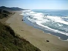
Ophir Beach looking southward
There is a state maintained safety rest area at Ophir Beach with picnic tables and restrooms.[5]
This beach is sometimes referred to as Nesika Beach.[6]
References
- "Ophir Beach". Geographic Names Information System. United States Geological Survey. Retrieved 2009-05-04.
- "Map of north end of Ophir Beach". Acme Mapper. Retrieved 2009-04-10.
- "Ophir Beach, United States". GeoNames. Retrieved 2009-04-08.
- "GeoNames". Retrieved 2009-04-10.
- "Oregon Hiking". Retrieved 2009-04-08.
- "Nesika Beach". Retrieved 2018-03-07.
Municipalities and communities of Curry County, Oregon, United States | ||
|---|---|---|
| Cities | 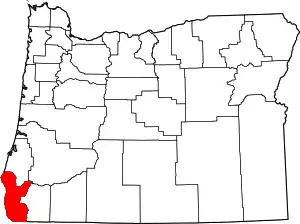 Curry County map | |
| CDPs | ||
| Other unincorporated communities | ||
| Ghost town | ||
| Indian reservation | ||
| Footnotes | ‡This populated place also has portions in an adjacent county or counties | |
| ||
This article is issued from Wikipedia. The text is licensed under Creative Commons - Attribution - Sharealike. Additional terms may apply for the media files.