Oppeln (region)
Regierungsbezirk Oppeln was a Regierungsbezirk, or government region, in the Prussian Province of Silesia, from 1813 to 1945, which covered the south-eastern part of Silesia.
Regierungsbezirk Liegnitz
Regierungsbezirk Breslau
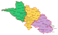
Regierungsbezirk Oppeln

Regierungsbezirk Oppeln in Silesia, 1905
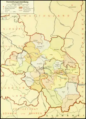
Districts in Gau Upper Silesia (1943)
Geography
The capital of the Regierungsbezirk was the Upper Silesian city of Oppeln. Other important cities in the region included Kattowitz, Gleiwitz, Beuthen, Königshütte, Hindenburg, Ratibor, Neustadt, Neisse and Kreuzburg.
It comprised the following districts (as of 1910):
|
Urban districts |
Rural districts
|
Population
Ethno-linguistic structure
| Year | Polish | German | Other (including bilingual) | |||
|---|---|---|---|---|---|---|
| Number | Percentage | Number | Percentage | Number | Percentage | |
| 1819[1] | 377,100 | 67.2% | 162,600 | 29.0% | 21,503 | 3.8% |
| 1828[2] | 418,437 | 61.1% | 255,483 | 37.3% | 10,904 | 1.6% |
| 1831[2] | 456,348 | 62.0% | 257,852 | 36.1% | 13,254 | 1.9% |
| 1834[2] | 468,691 | 62.6% | 266,399 | 35.6% | 13,120 | 1.8% |
| 1837[2] | 495,362 | 62.1% | 290,168 | 36.3% | 12,679 | 1.6% |
| 1840[2] | 525,395 | 58.6% | 330,099 | 36.8% | 41,570 | 4.6% |
| 1843[2] | 540,402 | 58.1% | 348,094 | 37.4% | 42,292 | 4.5% |
| 1846[2] | 568,582 | 58.1% | 364,175 | 37.2% | 45,736 | 4.7% |
| 1852[2] | 584,293 | 58.6% | 363,990 | 36.5% | 49,445 | 4.9% |
| 1855[2] | 590,248 | 58.7% | 366,562 | 36.5% | 48,270 | 4.8% |
| 1858[2] | 612,849 | 57.3% | 406,950 | 38.1% | 49,037 | 4.6% |
| 1861[2] | 665,865 | 59.1% | 409,218 | 38.3% | 51,187 | 4.6% |
| 1867[2] | 742,153 | 59.8% | 457,545 | 36.8% | 41,611 | 3.4% |
| 1890[2] | 918,728 | 58.2% | 566,523 | 35.9% | 92,480 | 5.9% |
| 1900[2] | 1,048,230 | 56.1% | 684,397 | 36.6% | 135,519 | 7.3% |
| 1905[2] | 1,158,805 | 56.9% | 757,200 | 37.2% | 117,651 | 5.8% |
| 1910[2] | 1,169,340 | 53.0% | 884,045 | 40.0% | 154,596 | 7.0% |
References
- Statistischer Umriss der Sammtlichen Europaischen und der Vornhemsten Aufseuropaischen Staaten (in German). 1823.
- Weber, Paul (1913). Die Polen in Oberschlesien; eine statistische Untersuchung. Robarts - University of Toronto. Berlin, J. Springer.
This article is issued from Wikipedia. The text is licensed under Creative Commons - Attribution - Sharealike. Additional terms may apply for the media files.