Oregon Route 334
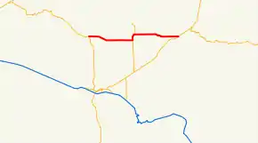
Oregon Route 334 (OR 334) is an Oregon state highway running from OR 37 near Myrick to OR 11 near Athena. OR 334 is known as the Athena-Holdman Highway No. 334 (see Oregon highways and routes). It is 18.12 miles (29.16 km) long and runs east–west, entirely within Umatilla County.
| ||||
|---|---|---|---|---|
 | ||||
| Route information | ||||
| Maintained by ODOT | ||||
| Length | 18.12 mi[1] (29.16 km) | |||
| Existed | 2003–present | |||
| Major junctions | ||||
| West end | ||||
| East end | ||||
| Highway system | ||||
| ||||

OR 334 was established in 2003 as part of Oregon's project to assign route numbers to highways that previously were not assigned, and, as of October 2020, was unsigned.
Route description
OR 334 begins at an intersection with OR 37 approximately ten miles north of Pendleton and heads east through Myrick. Three miles east of Myrick, OR 334 overlaps OR 335 for 1.13 miles (1.82 km), heading north. After OR 335 turns north toward Helix, OR 334 then continues east through Athena, ending at an intersection with OR 11 approximately one mile east of Athena.[1][2]
History
OR 334 was assigned to the Athena-Holdman Highway in 2003.
Major intersections
The entire route is in Umatilla County.
| Location | mi[1] | km | Destinations | Notes | |
|---|---|---|---|---|---|
| | 0.00 | 0.00 | Western terminus | ||
| | 8.44 | 13.58 | West end of concurrency | ||
| | 9.57 | 15.40 | East end of concurrency | ||
| | 18.12 | 29.16 | Eastern terminus | ||
| 1.000 mi = 1.609 km; 1.000 km = 0.621 mi | |||||
References
- "Highway Inventory Detail". Oregon Department of Transportation. Retrieved January 4, 2016.
- Google (January 4, 2016). "Oregon Route 334" (Map). Google Maps. Google. Retrieved January 4, 2016.