Orillia
Orillia /əˈrɪliə/[5] is a city in Ontario, Canada. It is in Simcoe County between Lake Couchiching and Lake Simcoe. Although it is geographically located within Simcoe County, the city is a single-tier municipality. It is part of the Huronia region of Central Ontario. The population in 2016 was 31,166.[4]
Orillia | |
|---|---|
| City of Orillia | |
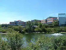
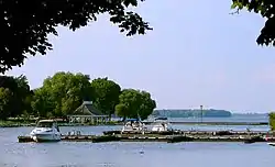 Waterfront of Orillia | |
 Flag | |
| Nickname(s): The Sunshine City | |
 Orillia | |
| Coordinates: 44°36′N 79°25′W | |
| Country | Canada |
| Province | Ontario |
| Incorporation | 1867 (Village) |
| Incorporation | 1875 (Town) |
| Incorporation | 1969 (City) |
| Government | |
| • Mayor | Steve Clarke |
| Area | |
| • Land | 28.58 km2 (11.03 sq mi) |
| Elevation | 219.50 m (720.14 ft) |
| Population (2016)[4] | |
| • Total | 31,166 |
| • Density | 1,090.3/km2 (2,824/sq mi) |
| Time zone | UTC−05:00 (EST) |
| • Summer (DST) | UTC−04:00 (EDT) |
| Forward Sortation Area | L3V |
| Area code(s) | 705 |
| Website | www |
It was incorporated as a village in 1867, but the history of what is today the City of Orillia dates back at least several thousand years. Archaeologists have uncovered evidence of fishing by the Huron and Iroquois peoples in the area over 4,000 years ago, and of sites used by Aboriginal peoples for hundreds of years for trading, hunting, and fishing.
Known as the "Sunshine City", the city's large waterfront attracts many tourists to the area every year, as do a number of annual festivals and other cultural attractions. While the area's largest employer is Casino Rama, overall economic activity in Orillia is a mixture of many different industries including manufacturing, government services, customer service and tourism.
Orillia is located on the shores of two connected lakes: Lake Simcoe and Lake Couchiching. Both lakes are part of the Trent-Severn Waterway. Travel north on Lake Couchiching, then through three locks and the only marine railway (Big Chute Marine Railway) still in use in North America leads to Georgian Bay on Lake Huron. Travel south-east across Lake Simcoe, through many locks (including two of the highest hydraulic lift locks in the world, Peterborough Lift Lock and Kirkfield Lift Lock) eventually leads to Lake Ontario. From either of these Great Lakes one can connect to the St. Lawrence and thence to the Atlantic Ocean.
History
The human history of the area extends back several thousand years: in the "Narrows", a small waterway that connects Lake Couchiching and Lake Simcoe, there is marine archaeological evidence of ancient fishing weirs used by Huron and Iroquois people to trap fish over 4,000 years ago. Also, there are several archaeological sites in the surrounding area that provide evidence of trading, fishing, and hunting camps that were visited for hundreds of years by indigenous people.
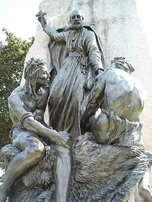
Also of historical note, the famed French explorer Samuel de Champlain visited the area that would later become Orillia in the summer of 1615, travelling over what would become the Coldwater Road centuries later; it was used by the Hurons, Ojibways, French and British as a fur-trading route. Champlain spent the winter with the Hurons in their chief village of Cahiague (near the current Warminster).[6] Ecole Samuel de Champlain, a local francophone elementary school, is named in his honour. A monument to Samuel de Champlain can also be found in Couchiching Beach Park and is a National Historic Site of Canada.
The government made treaties with the Hurons in 1798, 1815 and 1818 to gain land to the north and west of Lake Simcoe and then made grants to military veterans.[6] In 1840, the government bought extra land from the First Nations and laid out the settlement of Orillia. The population in 1846 was about 200. The settlement had a church, a post office, four stores, three taverns, a tannery, two blacksmiths, four shoemakers, a tailor, and two furniture makers. A grist mill could be found about a mile away.[7]
In 1869, the population was 1200. Construction of the Monck Road began in 1866 and was completed in 1873. A 100-mile stretch allowed for travel to Bancroft, Ontario where other roads could be found for travel to Ottawa.[6]
Transportation links with Toronto and Georgian Bay stimulated Orillia's development as a commercial centre and summer resort.[8] The village of Orillia was incorporated in 1867 (sharing the same birth year as Canada). By 1875 the population was 2,000 and Orillia became a town with a mayor, reeve, deputy reeve, and nine councillors.[9] Orillia was designated a city in 1969.[10]
In Stephen Leacock's 1912 book Sunshine Sketches of a Little Town, Orillia was used as the basis for the fictional town known as "Mariposa", although Leacock stated that the fictional town could really be any town. The book was based on Leacock's experiences in the town and since the book's release, the city has attempted to mimic the fictional location in as many ways as possible. The Leacock Museum and National Historic Site, located in Orillia, is one of the National Historic Sites of Canada.[11]
William E. Bell's 1989 novel Five Days of the Ghost was also set in Orillia, with many readers recognizing popular local spots, including the Guardian Angels Catholic Church, the Samuel de Champlain statue in Couchiching Beach Park as well as Chiefs Island in the middle of Lake Couchiching.
Orillia was the first municipality in North America to introduce daylight saving time[12] and had the first municipal hydroelectric transmission plant[13] in North America.
Etymology
The first recorded use of the name to describe the region, which until then had no officially sanctioned designation, was in 1820 when the name was given in York, Upper Canada by then Lieutenant-Governor Sir Peregrine Maitland. Maitland was a veteran of the British campaign against the French in Spain, called the Peninsular War, during the Napoleonic Wars where he served under the command of Wellington.
While there are no records clearly indicating the reason for the name Orillia, the most common explanation holds that the name originates in the Spanish, "orilla," which can mean the shore of either a lake or river. The Spanish pronunciation sounds much like, "oreeya," and since the word itself is spelled almost identically to Orillia, without the second, "i," it has come to be commonly accepted as the source word for the city's name. Further backing the theory of a Spanish origin are the names of surrounding communities and landmarks, which include Oro for gold, Mariposa for butterfly, and Mono for monkey. Historical documents contain a second spelling of the name which was never officially recognised, Aurelia, which when pronounced sounds similar to the name and is considered a clerical error.[14]
Demographics
| Year | Pop. | ±% |
|---|---|---|
| 1841 | 200 | — |
| 1871 | 1,322 | +561.0% |
| 1881 | 2,911 | +120.2% |
| 1891 | 4,752 | +63.2% |
| 1901 | 4,907 | +3.3% |
| 1911 | 6,828 | +39.1% |
| 1921 | 8,774 | +28.5% |
| 1931 | 8,183 | −6.7% |
| 1941 | 9,705 | +18.6% |
| 1951 | 12,110 | +24.8% |
| 1961 | 15,345 | +26.7% |
| 1971 | 24,040 | +56.7% |
| 1981 | 23,955 | −0.4% |
| 1991 | 25,925 | +8.2% |
| 1996 | 27,846 | +7.4% |
| 2001 | 29,121 | +4.6% |
| 2006 | 30,259 | +3.9% |
| 2011 | 30,586 | +1.1% |
| 2016 | 31,166 | +1.9% |
| [4] | ||
| Canada census – Orillia community profile | |||
|---|---|---|---|
| 2016 | 2011 | 2006 | |
| Population: | 31,166 (+1.9% from 2011) | 30,586 (+1.1% from 2006) | 30,259 (+3.9% from 2001) |
| Land area: | 28.58 km2 (11.03 sq mi) | 28.61 km2 (11.05 sq mi) | 28.61 km2 (11.05 sq mi) |
| Population density: | 1,090.3/km2 (2,824/sq mi) | 1,069.2/km2 (2,769/sq mi) | 1,057.8/km2 (2,740/sq mi) |
| Median age: | 47.0 (M: 44.4, F: 49.3) | 42.7 (M: 41.0, F: 44.2) | |
| Total private dwellings: | 14,287 | 13,863 | 13,013 |
| Median household income: | $55,802 | $46,722 | |
| References: 2016[15] 2011[1] 2006[16] earlier[17] | |||
According to the 2016 Canada Census, Orillia had a population of 31,116 living in an area of 28.58 square kilometres. The city has experienced growth for the past fifteen years, with a population increase of over 2,000 residents (7.0 percent) since the 2001 census. The median household income in 2015 for Orillia was $55,802, which is below the Ontario provincial average of $74,287.[4]
Government
Orillia is governed by the Orillia City Council, which consists of eight city councillors and a mayor.
There are four wards in the city.
From 1875 to 1969 the council was led by a reeve or mayor. Since 1969 the head of the council is the mayor.
Grape Island
Grape Island is a lake island located off Victoria Point in the north end of Lake Simcoe.
Today the island is occupied by about 40 private homes or cottages and residences are part of the Grape Island Property Owners Association (c. 1952).[18] Access is restricted to residents of the island with access by boat from Forest Avenue South dock to private docks on the island.[18] The heavy traffic at the mainland docks have resulted in tensions between island residents and residents of Victoria Point.[18] The city of Orillia is working on finding a solution for access to the island without inconveniencing residents in Victoria Point.[19]
There are no vehicular roads on the island. Only Ivy Lane, a road allowance, serves as path to homes on the island.[20] Water taxi is the main means of transportation to the island (unless residents have their own private vessels) from the GIPOA-owned mainland dock to the island dock (on a vacant lot). [20]
Economy
Initial interest in Orillia came from fur traders who used the gathering place at the Narrows to do business with the many tribes that came there each spring and fall. Subsequently, Orillia's economics has ranged from farming (even downtown) to machinery, to automobiles and even one of the first "campers" (a pop-up tent in a car).
Economic activity in Orillia is a mix of manufacturing, government services, customer service and tourism. The largest employer in the area is Casino Rama, located in the nearby reserve land of the Chippewas of Rama First Nation. Manufacturing operations in the city include CCI Thermal Technologies (industrial heaters and heating components), Dorr-Oliver Eimco (industrial equipment), Kubota Metal Corporation (petrochemical industry components), Parker Hannifin (moulded rubber products), Pliant Corporation (components for the packaging industry), Smiths Aerospace Components (aerospace industry machining) and TI Group Automotive Systems (automotive components). Call centre Tele Tech Canada also employs approximately 850 people. The Central Operations Headquarters for Ontario Provincial Police is located in Orillia (Memorial Drive), as is the regional headquarters.
Heywood-Wakefield seating, which operated from the early 20th century, announced it was closing its doors in September 2007. In late July 2009, Parker Hannifin announced that they were shutting down their operations in Orillia at the end of the year.[21]
G.W.B. Rope & Twine, which was one of the foremost North American producers of braided rope from 1973 to 1985, was also the inventor of the automotive grocery or cargo restraint net. The net was introduced with the launch of the Ford Taurus at Christmas 1985, and shortly thereafter the company was sold and became Polytech Netting Industries, which employed several hundred people until moving to Mexico in 1996–97. G.W.B. Rope and Twine's founders, Gordon W. Brown and family, launched G&B Ropes in 1990. (Their son Sean Brown worked with G&B Ropes until it transferred ownership around 1998. Sean Brown then assisted in the development of Orillia's newest rope-making business, Redpoint Ropes.)
Large public-sector employers include the headquarters for the Ontario Provincial Police, which is located in Orillia. The Huronia Regional Centre, formerly an asylum that later became an institution to house disabled people, was one of the area's largest employers for many decades until the de-institutionalization movement of the 1980s and 1990s.
Recreation and culture
Orillia is known as the "Sunshine City", taking the moniker from its role as the fictional "Mariposa" in the book Sunshine Sketches of a Little Town by Stephen Leacock. Many local businesses also use "Mariposa" in their names.
The city council has actively restricted the construction of large buildings downtown and seeks to maintain a certain "small town" look with regard to signs and decorations. However, in 2017, plans were further discussed to redevelop the waterfront district and other areas underdeveloped or otherwise vacant. A 3D model was developed at the local Royal Canadian Legion to reflect the possible future and is to be on display in city hall.
Orillia's "Arts District" is located on Peter St. S., between Mississauga St. E. and Colborne St. E., and is home to a variety of art galleries, fine dining and shops. At its centre is the Orillia Museum of Art & History, considered the hub of art and culture for the city, playing an instrumental role in municipal cultural events.
The museum occupies all four floors of the historic Sir Sam Steele Building, a landmark destination for both residents and visitors. A collection of over 10,000 artefacts of regional historical significance features in a rotating exhibits schedule. On a separate floor is contemporary art space with exhibits featuring regional and international artists. The museum also features a designated education space and hosts activities including art-making and interpretive programming for children, artists, artisans, historians, etc.
Many tourists and boaters are attracted to the city each year because of its waterfront park Couchiching Beach Park/Centennial Park/Port of Orillia and its position as a gateway to Lake Country, cottage country in Muskoka, Algonquin Provincial Park, the Trent–Severn Waterway and other natural attractions. The city's waterfront has an extensive lakeshore boardwalk, a large park with two beaches, several playgrounds, an outdoor theatre, a touring ferry, and a children's train.
The city of Orillia also is home to a large number of retirement homes (currently nine, with four more under construction). As such, it is often characterized as a "retirement community", although less than 18% of the city's population is actually over 65 (see below).
Orillia is home to an annual Perch Fishing Festival. Perch are netted, tagged, and released into the local lake, to be caught for prize money. This event also includes a large social gathering consisting of a "perch fry". Other popular annual festivals include the Leacock Festival, Blues Festival, Jazz Festival, Scottish Festival, and Beatles Festival.
The Port of Orillia holds an annual "Christmas in June", which includes a boat decorating contest and turkey buffet. Boat and cottage shows are held in June and August.
Orillia also hosts an annual Canada Day event at Couchiching Beach Park.[22] The day begins with a traditional pancake breakfast served by the Mayor and Council, and ends with a large fireworks display at dusk.
Orillia is the original and current site of the popular Mariposa Folk Festival. Begun in 1961, it is the longest-running folk festival in Canada.[23]
The Stephen Leacock Associates have honoured former Orillia resident and humourist Stephen Leacock's memory since 1947 with the annual Stephen Leacock Memorial Medal for Humour, awarded to the best Canadian humorous book published the previous year. The Leacock Medal Gala and Award ceremony is held each June at nearby Geneva Park, with tickets for sale to the public.
The Royal Canadian Legion sponsors a yearly Scottish Festival at Couchiching Beach Park and Centennial Park in July each year. Marching bands from around the country participate.
Since 1963, the Webers hamburger restaurant has been approximately 1 km north of Orillia,[24] next to Ontario Highway 11.[25][26]
Lake St. George Golf Club is ten minutes north of Orillia.
Education
Both French and English public education is offered in Orillia.
There is one Catholic French-language elementary school, École élémentaire catholique Samuel-de-Champlain, operated by the Conseil scolaire de district catholique Centre-Sud.[27]
Students from this elementary school attend École secondaire catholique Nouvelle-Alliance, which is operated by the same board and is located in Barrie.[28]
English public education in Orillia is provided via the Simcoe County District School Board, which has nine elementary and three secondary schools in the city. The secondary schools are Twin Lakes Secondary School, Orillia Secondary School, formerly OD/Park Secondary School and originally called Orillia District and Vocational Institute and Park Street Collegiate Institute. The schools joined together in the summer of 2013. There is also an alternative secondary school, known as OASIS.
Publicly funded Catholic English-language education is available via the Simcoe Muskoka Catholic District School Board through four elementary schools and one secondary school, Patrick Fogarty Catholic Secondary School.
Private schools include the Orillia Christian School.
There are two post-secondary institutions that are based in Orillia. The Orillia campus of Georgian College, offers applied arts and technology programmes to 1,600 students. Lakehead University operates a small campus downtown, with the main campus on a new site on University Ave. The Orillia campus opened[29] in the downtown in 2006 and the campus on University Ave. opened in September 2010. The Lakehead University campus located on University Avenue is the first in North America that has been built to meet all LEED® (Leadership in Energy and Environmental Design) certification standards.[30]
There is also an Adult Learning Centre, where adults may upgrade to receive high school diplomas.
Health care
The Orillia Soldiers' Memorial Hospital is a 230-bed hospital in the city. Opened in 1908 as the 20-bed Orillia General Hospital, it took its current name in 1922 to honour those who died fighting in World War I.[31] Orillia Soldiers’ Memorial Hospital celebrated its 100th anniversary on May 28, 2008.[32] The hospital is located at 170 Colborne Street West, Orillia, ON L3V 2Z3.[33]
Transit
Orillia Transit provides service on five routes throughout the city. All of these routes run on loops which depart and end at the downtown bus terminal at the intersection of West and Mississaga Streets. Orillia Transit services commence at 6:15 a.m., ending at 10:15 p.m. on weekdays with all final departures from the terminal and shorter operating hours on weekends with no holiday service.[34]
In August 2019, Simcoe County LINX began a bus route that connects Orillia with Barrie on weekdays, excluding statutory holidays.[35]
Climate
| Climate data for Orillia | |||||||||||||
|---|---|---|---|---|---|---|---|---|---|---|---|---|---|
| Month | Jan | Feb | Mar | Apr | May | Jun | Jul | Aug | Sep | Oct | Nov | Dec | Year |
| Record high °C (°F) | 10.0 (50.0) |
13.0 (55.4) |
23.0 (73.4) |
29.5 (85.1) |
32.5 (90.5) |
34.0 (93.2) |
37.5 (99.5) |
34.0 (93.2) |
32.5 (90.5) |
27.0 (80.6) |
21.5 (70.7) |
17.0 (62.6) |
37.5 (99.5) |
| Average high °C (°F) | −3.6 (25.5) |
−2.7 (27.1) |
2.9 (37.2) |
10.7 (51.3) |
18.2 (64.8) |
22.5 (72.5) |
25.7 (78.3) |
24.2 (75.6) |
19.3 (66.7) |
12.2 (54.0) |
5.8 (42.4) |
−0.7 (30.7) |
11.2 (52.2) |
| Daily mean °C (°F) | −8.4 (16.9) |
−7.7 (18.1) |
−2.1 (28.2) |
5.7 (42.3) |
12.9 (55.2) |
17.1 (62.8) |
20.6 (69.1) |
19.4 (66.9) |
14.8 (58.6) |
8.2 (46.8) |
2.2 (36.0) |
−4.8 (23.4) |
6.5 (43.7) |
| Average low °C (°F) | −13.1 (8.4) |
−12.6 (9.3) |
−7.0 (19.4) |
0.8 (33.4) |
7.5 (45.5) |
11.5 (52.7) |
15.5 (59.9) |
14.6 (58.3) |
10.2 (50.4) |
3.9 (39.0) |
−1.3 (29.7) |
−8.8 (16.2) |
1.8 (35.2) |
| Record low °C (°F) | −37.0 (−34.6) |
−37.0 (−34.6) |
−30.0 (−22.0) |
−15.0 (5.0) |
−3.5 (25.7) |
0.5 (32.9) |
7.0 (44.6) |
4.0 (39.2) |
−3.0 (26.6) |
−6.0 (21.2) |
−9.0 (15.8) |
−35.0 (−31.0) |
−37.0 (−34.6) |
| Average precipitation mm (inches) | 103.1 (4.06) |
68.1 (2.68) |
71.3 (2.81) |
72.2 (2.84) |
77.6 (3.06) |
76.4 (3.01) |
77.4 (3.05) |
102.4 (4.03) |
95.5 (3.76) |
89.7 (3.53) |
102.5 (4.04) |
107.3 (4.22) |
1,043.2 (41.07) |
| Average rainfall mm (inches) | 13.9 (0.55) |
15.4 (0.61) |
38.4 (1.51) |
60.9 (2.40) |
77.3 (3.04) |
76.4 (3.01) |
77.4 (3.05) |
102.4 (4.03) |
95.3 (3.75) |
86.5 (3.41) |
77.1 (3.04) |
29.6 (1.17) |
750.6 (29.55) |
| Average snowfall cm (inches) | 89.2 (35.1) |
59.6 (23.5) |
32.9 (13.0) |
11.3 (4.4) |
0.4 (0.2) |
0 (0) |
0 (0) |
0 (0) |
0 (0) |
3.2 (1.3) |
25.4 (10.0) |
77.7 (30.6) |
292.6 (115.2) |
| Average precipitation days (≥ 0.2 mm) | 16.9 | 11.8 | 12.4 | 12.0 | 12.8 | 11.7 | 9.8 | 12.5 | 13.6 | 15.3 | 15.7 | 16.9 | 161.3 |
| Average rainy days (≥ 0.2 mm) | 2.6 | 2.3 | 6.5 | 10.6 | 12.7 | 11.7 | 9.8 | 12.5 | 13.6 | 15.0 | 12.3 | 4.5 | 114.2 |
| Average snowy days (≥ 0.2 cm) | 14.8 | 10.2 | 6.5 | 2.2 | 0.17 | 0 | 0 | 0 | 0 | 0.73 | 4.7 | 13.4 | 52.7 |
| Source: Environment Canada[3] | |||||||||||||
Environmental issues
In 2012, Orillia won the highest municipal honour for its waste diversion efforts. The City of Orillia had a waste diversion rate of 61% in 2011. The Recycling Council of Ontario awarded the city its highest award, the Platinum Municipal Diversion Award.[36]
Ontario Provincial Police headquarters
As part of an initiative to decentralise its services, the provincial government relocated the headquarters of the Ontario Provincial Police to Orillia. The office was initially located in the Tudhope Building downtown (part of which is currently used as the Orillia City Hall) until the new building was opened in 1995. The headquarters, known as the Lincoln M. Alexander Building, is located on Memorial Avenue near the Huronia Regional Centre. The building houses the assorted bureaus and divisions that make up the general headquarters, as well as the Provincial Police Academy, and The OPP Museum.
OPP Central Region Headquarters is located on Hurtubise Road,[37] near the intersection of Hwy 12 and Memorial Avenue.
The OPP also provides municipal policing to the City of Orillia under contract from a detachment located in the downtown core. The city's police force was disbanded when the policing contract began in 1996.
Media
Radio
- FM 105.9 - CICX-FM "Kicx 106", country music
- FM 89.1 - CISO-FM "Sunshine 89.1 FM" Adult Contemporary
- FM 98.5 - CIOA-FM - tourist information station
There are also rebroadcast transmitters for CBC Radio:
- FM 90.7 - CBL-FM-3 (CBC Radio 2, repeating CBL-FM Toronto)
- FM 91.5 - CBCO-FM (CBC Radio One, repeating CBLA-FM Toronto)
TV
Television stations and rebroadcasters based in the vicinity of Orillia are:
| OTA virtual channel (PSIP) | OTA channel | Rogers Cable | Call Sign | Network | Notes |
|---|---|---|---|---|---|
| 3.1 | 10 (VHF) | 5 | CKVR-DT | CTV 2 | Transmitted from Barrie |
| 7.1 | 7 (VHF) | 13 | CIII-DT-7 | Global | Transmitted from Midland; rebroadcaster of CIII-DT-41 (Toronto) |
| – | 21 (UHF) | 8 | CFTO-TV-21 | CTV | Rebroadcaster of CFTO-DT (Toronto) |
The incumbent cable television provider in Orillia is Rogers Cable.
Notable residents
- A. Charles Baillie, Chancellor of Queen's University
- James Bartleman, diplomat and Lieutenant Governor of Ontario
- William E. Bell, author
- David G. Benner, psychologist and author
- Franklin Carmichael, one of the Group of Seven
- Leslie Frost, Premier of Ontario
- Jake Gaudaur, football player
- Jake Gaudaur Sr., champion oarsman
- Walter Knox, athlete and athletics coach
- John Lawless, ice hockey player inducted to the British Ice Hockey Hall of Fame
- Stephen Leacock, humourist
- Matt Lennox, novelist
- Doug Lewis, politician and lawyer
- Rick Ley, hockey player
- Gordon Lightfoot, singer/songwriter of classics like "If You Could Read My Mind" and "Wreck of the Edmund Fitzgerald"
- Robert W. Mackenzie, politician
- Ethan Moreau, Columbus Blue Jackets hockey player
- Jack Reid, artist, watercolours
- Ted Roop, Morning Radio Show Host - 104.1 The DOCK
- Sir Samuel Steele, soldier and member of the Royal Canadian Mounted Police
- Earl Valiquette, football player
- Luke Wiles, lacrosse player
- Elizabeth Wyn Wood, sculptor
- Marnie Woodrow, novelist
Notes and references
- "2011 Community Profiles". 2011 Canadian Census. Statistics Canada. July 5, 2013. Retrieved 2012-03-06.
- "Orillia (Census agglomeration) census profile". 2011 Census of Population. Statistics Canada. Retrieved 2012-03-06.
- Environment Canada — Canadian Climate Normals 1971–2000, accessed 15 April 2012
- Canada, Government of Canada, Statistics. "Census Profile, 2016 Census Orillia, City and Province of Ontario". Retrieved July 8, 2019.
- "Orillia pronunciation: How to pronounce Orillia in English". Forvo.com. Retrieved 21 October 2017.
- "Champlain in Ontario, 1615". OntarioPlaques.com. Alan L. Brown. Retrieved July 7, 2019.
- Smith, Wm. H. (1846). Smith's Canadian Gazetteer - Statistican and General Information Respecting all parts of the Upper Province, or Canada West. Toronto: H. & W. Rowsell. pp. 134–135.
- "Founding of Orillia". Ontario Heritage Trust. Retrieved July 7, 2019.
- "History". Retrieved August 10, 2019.
- "Heritage Home Page". City of Orillia. Retrieved August 10, 2019.
- "Leacock Museum National Historic Site". Retrieved August 10, 2019.
- "Bold attempt at daylight saving time became a comic failure in Orillia". Toronto Star. 8 July 2017. Retrieved August 10, 2019.
- "FIRST HYDRO-ELECTRIC PLANT - Orillia, Ontario CANADA". Retrieved August 10, 2019.
- Why Call it That? by Ross McDonald, published by the Orillia Historical Society. Page 2
- "2016 Community Profiles". 2016 Canadian Census. Statistics Canada. February 21, 2017. Retrieved 2019-07-08.
- "2006 Community Profiles". 2006 Canadian Census. Statistics Canada. March 30, 2011. Retrieved 2012-03-06.
- "2001 Community Profiles". 2001 Canadian Census. Statistics Canada. February 17, 2012.
- Dawson, Dave (January 23, 2018). "Council's Grape Island decision 'not fair to anyone'". OrilliaMatters.com. Retrieved July 7, 2019.
- Hashizume, Ken (September 11, 2018). "Search for New Location for Grape Island Dock". Bayshore Broadcasting. Retrieved July 7, 2019.
- "14 Ivy Lane" (PDF). Chestnut Park Real Estate Limited. Retrieved July 7, 2019.
- "Simcoe County Breaking News - Simcoe County's Online Newspaper - Simcoe.com". Simcoe.com. Retrieved 21 October 2017.
- "Orillia Canada Day". Retrieved 10 August 2019.
- "History - Mariposa Folk Foundation". Mariposa Folk Foundation. Retrieved 2018-05-30.
- "Webers Location Google Maps". Google Maps. Retrieved 19 August 2015.
- Sue Campbell & Jen McMorran. "Canada's 8 Greatest Burger Restaurants". Reader's Digest. Retrieved 19 October 2012.
- Ogilvie, Megan (3 August 2012). "The dish on cottage country's famous foodie treats: burgers to butter tarts". Toronto Star. Retrieved 19 October 2012.
- École élémentaire catholique Samuel-de-Champlain
- École secondaire catholique Nouvelle-Alliance
- "Lakehead University". Lakehead University. Archived from the original on 8 December 2010. Retrieved 21 October 2017.
- "Quick Facts | Lakehead University". Lakehead University. Retrieved 2018-05-30.
- "Welcome to Soldiers' - Our History". Orillia Soldiers' Memorial Hospital. Retrieved 26 August 2014.
- "OSMH - Our History". www.osmh.on.ca. Retrieved 2018-05-30.
- "Orillia Soldiers' Memorial Hospital, Orillia - Colborne St". centraleastontario.cioc.ca. Retrieved 2018-05-30.
- "About Orillia Transit". www.orillia.ca. Retrieved 2018-05-30.
- "Transit: Routes/Schedule". County of Simcoe. Retrieved August 16, 2019.
- "City wins highest municipal honour for its waste diversion efforts". City of Orillia. Retrieved 21 October 2017.
- Winton Sarvis, Gisele (23 June 2013). "New OPP headquarters opens". Barrie Examiner. QMI. Retrieved 10 May 2016.
External links
| Wikimedia Commons has media related to Orillia. |
Places adjacent to Orillia | |
|---|---|
| Regions | |
|---|---|
| Counties | |
| Districts | |
| Regional municipalities | |
| Single-tier municipalities | |
| Separated municipalities | |
| |