Otter Dock
Otter Dock was a branch of the Grand Junction Canal (renamed Grand Union Canal from 1929) in Yiewsley, Middlesex.
| Otter Dock | |
|---|---|
 | |
| Specifications | |
| Length | 1.0 mile (1.6 km) |
| Status | Filled in |
| History | |
| Construction began | 1818 |
| Date completed | 1820 |
| Date closed | 1909 |
| Geography | |
| Connects to | Grand Junction Canal |
In March 1818, permission was obtained from the Grand Junction Canal Company by a Mr John Mills for a dock to be built to service Yiewsley’s brickmaking industry. Otter Dock would be the longest of nine arms and docks that served Yiewsley's industries.[1] It was opened in 1820 and after several expansions extended 1,200 yards (0.7 of a mile /1.1 km) north from the mainline of the canal.[2] With the inclusion of the arms within Otter dock, its total length was 1845 yards (1.05 miles /1.68 km).[1]
Brick-earth was moulded and fired in Yiewsley’s brick-fields with the finished bricks being transported via the Otter Dock and the Grand Junction Canal Paddington Arm to the South Wharf in the Paddington Basin and to wharves situated along the Regent's Canal.[3] The bricks were then used in the construction of 19th-century London.
Grand Junction Canal arms and docks in Yiewsley Parish and Yiewsley (and West Drayton) Urban District (west to east)
| Grand Junction Canal arms and docks | Length[1] |
| Yiewsley Dock/Onslow Mills | 75yds |
| Bentinck/Holland's Dock | 35yds (2) |
| Otter Dock | 1845yds |
| Cooper's Dock | 175yds |
| Liddall's/Eastwood's Dock | 610yds |
| Rutter's Dock | 20yds (2) |
| Sabey's Dock | 350yds |
| Dawley Dock | 320yds |
| Pocock’s/Broad's/Starveall/Stockley Dock | 1120yds |
(2) Measured from Ordnance Survey Middlesex XIV.SE Revised 1894

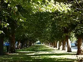
By the beginning of the 20th century, the brick-fields and the later gravel pits which the Otter Dock served had been worked out. Work started to fill in Otter Dock north of Horton Road in 1909 and was completed in 1911.[4] In 1910 chestnut and beech trees were planted along the filled-in canal between Colham Road (known as Wharf or Dock Road until May 1904[5]) and Ernest Road in the southern section of the former Arm. The roads were renamed Colham Avenue in 1938.[6] The wide boulevard of Poplar Avenue was part of the northern section of the Arm.
References
- Faulkner, Alan H. (1972). The Grand Junction Canal. Newton Abbot: David and Charles (Publishers) Limited. pp. 97, 202. ISBN 0715357506.
- "Middlesex XIV.S.E. revised 1894". maps.nls.uk. Ordnance Survey Second edition 1897. Retrieved 5 June 2020.
- Ian Petticrew and Wendy Austin (October 2012). "The Grand Junction Canal A Highway Laid With Water". tringhistory.tringlocalhistorymuseum.org.uk. Tring and District Local History & Museum Society. Retrieved 14 June 2020.
- Cox, A.H. (1983). West Drayton & Yiewsley through the centuries. Hillingdon Borough Libraries. p. 34. ISBN 0907869033.
- "Middlesex and Buckinghamshire Advertiser, Uxbridge, Harrow & Watford Journal". 7 May 1904. p. 7.
- Skinner, James (2003). Images of England West Drayton and Yiewsley. Tempus Publishing. p. 13. ISBN 9780752428413.