Outer Ring Road, Erode
Outer Ring Road is a 22-kilometer (14 mi) long Ring Road being constructed around the South Indian City of Erode in Tamil Nadu. It also acts as an easy roadway for connecting Namakkal district with Erode.
| Outer Ring Road, Erode | |
|---|---|
| Route information | |
| Maintained by Highways and Minor Ports Department | |
| Length | 22 km (14 mi) |
| Status | Under Construction (Partly opened) |
| Major junctions | |
| South end | Kokkarayanpet |
| Lakkapuram Thindal | |
| North end | Chithode |
| Highway system | |
The state Government of Tamil Nadu has sanctioned the project in 2006, with a funding of ₹85 crore, with a land acquisition of 180acres. Among which, ₹30 crore will be given as compensation for 120 acres of private patta land.[1]
Traffic in the City
Erode city, being the district headquarters and a major marketing hub in the region, has an extensive network of radial roads originating from core city and the growth of the city is along these transport corridors. This results in the rapid increase in traffic congestion inside the core city. Also, the number of trucks entering the city is significantly high. The narrow and congested city roads does not cater to the increasing traffic needs.[2] This paved the need for developing better road infrastructure for vehicles travelling across Erode.[3]
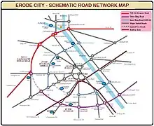
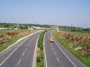
The four-laned National Highway 544 connecting Salem with Cochin has been strategically planned and constructed along the western periphery of the city through Lakshmi Nagar, Chithode, Gangapuram and Nasiyanur areas to reach Perundurai, is a natural bypass for Erode in the west.[4] Due to the presence of this highway, the growth pattern of the city is in North-west direction.[5] Vehicles from Erode city can access this highway through the arterial roads like Sathy road, Bhavani road, Nasiyanur road and Perundurai Road. But still the traffic due to the vehicles flowing from South and East of the City makes traffic worse. So, the demand raised for the construction of Outer Ring Road for the city.
Ring formation around the city
The ring road around the city would be made by connecting the new ring road in south with the NH 544 bypass near Gangapuram,[6] which further connects Chithode, Bhavani and to Komarapalayam in Namakkal district. The road is expected to divert around 2200 trucks and buses away from the city roads.[7] This stretch linking Kokkarayanpet with Bhavani will make a semi-circular ring around the city.
Also, the access to the fast growing urban nodes located in the eastern side of River Kaveri like Pallipalayam, Sankagiri and Tiruchengode is limited with a single Cauvery Bridge. The Comprehensive Mobility Plan submitted by Erode Municipal Corporation suggests networking of road to these areas for better transit.[8] With the networking of these eastern areas, the ring formation would be made complete.
Phases of construction
Erode Ring Road project is being executed in two sectors.
Part-I
This southern section of the Outer Ring road starts from Kokkarayanpet in Namakkal district and ends near Nanjanapuram beyond Thindal along Perundurai Road in Erode. The road is laid for a width of 7 meters (2 lane road) with a provision of expansion for up to 30 meters. This stretch is constructed in three phases
- Phase-I: The first phase starts at Kokkarayanpet in the east and ends near Lakkapuram along SH 84. This phase of the road has been constructed at a cost of ₹12 crore. This stretch includes a high-level bridge across Kaveri River and a level-crossing on Erode-Tiruchirappalli line.
- Phase-II: The second phase of the road connects SH 84 with Anaikkalpalayam on SH 83A through 46 Pudur. This part of the road constructed at a cost of ₹25 crore, intersects NH-381A near Lakkapuram.
- Phase-III: The third phase of the road connects Anaikkalapalayam along Poondurai Road with Nanjanapuram along Perundurai Road. This stretch covers a length of 7.2 km including the Railway over bridge near Jeeva Nagar. The Government sanctioned a cost of ₹69.3 crore and is expected to be completed during Feb-March 2017.[9]
The 7.6 km stretch of the road under phase-I & II has been opened for public to transit between Kokkarayanpet and Anaikalpalayam.[10][11] The phase-III also includes widening of the 2-lane stretch under phase-I & II into a 4-lane road of 30 meters width.[12]
Part-II
This western section of the Outer Ring road is planned to connect Perundurai Road with Bhavani Road. Initially, as per the master plan of Erode LPA drawn in 1996, it was planned to connect Palayapalayam with BP Agraharam through Soolai. Later due to growth of residential areas, it was redrawn to connect Thindal with Villarasampatti(Nasiyanur Road), Periyasemur(Sathy Road) and BP Agraharam(Bhavani Road) for 9.6 km.[13] But later, considering the increasing traffic and population in the areas of Periyasemur and BP Agraharam, the alignment has been restructured.
In 2015, the Highways department has prepared a proposal to connect Nanjanapuram near Thindal with Chithode via Nasiyanur, which will further connect Bhavani via Lakshmi Nagar.[14] The stretch between Nasiyanur-Chithode and Bhavani road is now part of the National Highway 544 Bypass.
Highways Department is awaiting the financial clearance to take up this project under TNRSP or with World Bank funding. Until execution of this Nanjanapuram-Nasiyanur section, the Highways Department has decided to widen the existing link road connecting Thindal-Villarasampatti-Periyasemur into a 4-lane Inner Ring Road as a temporary relief.
References
- "Ring Road for Erode at a cost of 85 crore sanctioned". the Hindu. Retrieved 20 December 2016.
- "Funds sanctioned for third phase of Ring Road project in Erode". the Hindu. Retrieved 20 December 2016.
- Erode City Mobility Plan, page 15 (PDF). Erode Municipal Corporation. Retrieved 21 December 2016.
- "Erode Ring Road to be considered favourably". the Hindu. Retrieved 20 December 2016.
- Erode City Mobility Plan, page 16 (PDF). Erode Municipal Corporation. Retrieved 21 December 2016.
- "Ring Road works to be over on time". the Hindu. Retrieved 20 December 2016.
- "Work to acquire land for Erode Ring Road project begins". the Hindu. Retrieved 20 December 2016.
- Erode City Mobility Plan, page 16 (PDF). Erode Municipal Corporation. Retrieved 21 December 2016.
- "Third phase execution of Ring Road project on steam". the Hindu. Retrieved 20 December 2016.
- Highways and Minor ports policy Note 2014-2015 (PDF). Dept. of Highways and Minor Ports, Tamil Nadu, page 148. Retrieved 21 December 2016.
- "Rain slows down works on Erode Ring Road". the Hindu. Retrieved 20 December 2016.
- "Plans to expand Erode LPA". the Hindu. Retrieved 20 December 2016.
- "Work to acquire land for Erode ring road project begins". the Hindu. Retrieved 20 December 2016.
- "Thindal-Chithode link of Ring Road awaited". the Hindu. Retrieved 20 December 2016.