Paganella
Paganella is a mountain of the Brenta Group in Trentino, northern Italy. It is located in the territories of the comuni of Fai della Paganella, Andalo, Molveno, Zambana and Terlago. Overlooking Trento from north-west, it consists of a short range/plateau with a highest elevation of 2,125 m (Roda Peak).
| Paganella | |
|---|---|
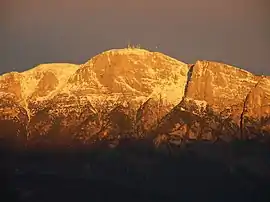 Paganella at dawn, seen from Povo | |
| Highest point | |
| Elevation | 2,124 m (6,969 ft) |
| Prominence | 1,099 m (3,606 ft) [1] |
| Coordinates | 46°10′00″N 11°04′00″E |
| Geography | |
 Paganella Location in the Alps | |
| Location | Trentino, Italy |
| Parent range | Brenta Group, Rhaetian Alps |
The slopes above Andalo and Fai are rich in vegetation and also houses several ski resorts, while the other descends towards the Adige river are steeper and rockier.
Climate
Due to altitude, the climate is tundra (Köppen: ET), similar to other high mountains in the Alps.[2]
| Climate data for Paganella (ridge), elevation: 2,129 m or 6,985 ft, 1961-1990 normals | |||||||||||||
|---|---|---|---|---|---|---|---|---|---|---|---|---|---|
| Month | Jan | Feb | Mar | Apr | May | Jun | Jul | Aug | Sep | Oct | Nov | Dec | Year |
| Average high °C (°F) | −2.2 (28.0) |
−2.4 (27.7) |
−1.0 (30.2) |
1.6 (34.9) |
6.4 (43.5) |
11.0 (51.8) |
13.8 (56.8) |
13.2 (55.8) |
10.2 (50.4) |
6.0 (42.8) |
1.0 (33.8) |
−1.2 (29.8) |
4.7 (40.5) |
| Average low °C (°F) | −7.4 (18.7) |
−7.4 (18.7) |
−6.0 (21.2) |
−3.4 (25.9) |
0.7 (33.3) |
4.1 (39.4) |
6.1 (43.0) |
6.0 (42.8) |
4.5 (40.1) |
1.4 (34.5) |
−3.4 (25.9) |
−6.3 (20.7) |
−0.9 (30.4) |
| Average precipitation mm (inches) | 30.9 (1.22) |
23.7 (0.93) |
40.9 (1.61) |
40.0 (1.57) |
67.6 (2.66) |
86.3 (3.40) |
95.4 (3.76) |
93.7 (3.69) |
90.3 (3.56) |
73.1 (2.88) |
50.5 (1.99) |
27.4 (1.08) |
719.8 (28.35) |
| Average precipitation days (≥ 1.0 mm) | 5.2 | 4.6 | 6.4 | 7.8 | 10.1 | 11.3 | 9.9 | 10.1 | 7.1 | 7.1 | 7.3 | 4.7 | 91.6 |
| Average relative humidity (%) | 61 | 67 | 70 | 78 | 78 | 76 | 73 | 75 | 73 | 71 | 64 | 60 | 71 |
| Source: NOAA[3] | |||||||||||||
References
- "La Paganella - peakbagger". peakbagger.com. Retrieved 15 March 2015.
- "Distance Between Paganella Mountain, Italy & Cities Beginning with L". www.paganella.climatemps.com. Retrieved 2019-07-18.
- "Paganella (16022) - WMO Weather Station". NOAA. Retrieved July 15, 2019.
This article is issued from Wikipedia. The text is licensed under Creative Commons - Attribution - Sharealike. Additional terms may apply for the media files.