Palmarito
Palmarito (Barrio Palmarito) is a rural barrio in the municipality of Corozal, Puerto Rico. Its population in 2010 was 2,227.[3][4][5]
Palmarito | |
|---|---|
Barrio | |
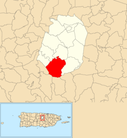 Location of Palmarito within the municipality of Corozal shown in red | |
 Palmarito Location of Puerto Rico | |
| Coordinates: 18°15′36″N 66°20′35″W[1] | |
| Commonwealth | |
| Municipality | |
| Area | |
| • Total | 4.93 sq mi (12.8 km2) |
| • Land | 4.93 sq mi (12.8 km2) |
| • Water | 0 sq mi (0 km2) |
| Elevation | 1,982 ft (604 m) |
| Population (2010) | |
| • Total | 2,227 |
| • Density | 451.7/sq mi (174.4/km2) |
| Source: 2010 Census | |
| Time zone | UTC−4 (AST) |
Features and demographics
Palmarito has 4.93 square miles (12.8 km2) of land area and no water area. In 2010, its population was 2,227 with a population density of 451.7 inhabitants per square mile (174.4/km2).
| Historical population | |||
|---|---|---|---|
| Census | Pop. | %± | |
| 1900 | 770 | — | |
| 1910 | 1,187 | 54.2% | |
| 1920 | 1,241 | 4.5% | |
| 1930 | 1,336 | 7.7% | |
| 1940 | 1,696 | 26.9% | |
| 1950 | 1,995 | 17.6% | |
| 1980 | 1,944 | — | |
| 1990 | 1,902 | −2.2% | |
| 2000 | 2,160 | 13.6% | |
| U.S. Decennial Census[6] 1899 (shown as 1900)[7] 1910-1930[8] 1930-1950[9] 1980-2000[10] 2010[11] | |||
History
Puerto Rico was ceded by Spain in the aftermath of the Spanish–American War under the terms of the Treaty of Paris of 1898 and became a territory of the United States. In 1899, the United States conducted its first census of Puerto Rico finding that the population of Palmarito barrio was 770.[12]
Sectors
Barrios (which are like minor civil divisions)[13] in turn are further subdivided into smaller local populated place areas/units called sectores (sectors in English). The types of sectores may vary, from normally sector to urbanización to reparto to barriada to residencial, among others.[14][15][16]
The following sectors are in Palmarito barrio:[17]
Palmarito
Parcelas Berio Nuevas, Parcelas Berio Viejas, Sector Albaladejo, Sector Chago Torres, Sector Che Díaz, Sector Eduardo Rivera, Sector El Riachuelo, Sector Félix Padilla, Sector Finito Santiago, Sector Frank Ortiz, Sector Geño Rivera, Sector Los Molina, Sector Pifio Rivera, Sector Pimo Ortiz, and Urbanización Estancias de la Montaña.
Palmarito Centro
Sector El Cuatro, Sector El Perico (La PRA), Sector Finín Lozada, Sector La Gallera, Sector Los Montesino, Sector Los Peña, Sector Marciano Burgos, and Sector Radio Oro (La Emisora).
References
- "US Gazetteer 2019". US Census. US Government.
- U.S. Geological Survey Geographic Names Information System: Palmarito barrio
- Picó, Rafael; Buitrago de Santiago, Zayda; Berrios, Hector H. Nueva geografía de Puerto Rico: física, económica, y social, por Rafael Picó. Con la colaboración de Zayda Buitrago de Santiago y Héctor H. Berrios. San Juan Editorial Universitaria, Universidad de Puerto Rico,1969.
- Gwillim Law (20 May 2015). Administrative Subdivisions of Countries: A Comprehensive World Reference, 1900 through 1998. McFarland. p. 300. ISBN 978-1-4766-0447-3. Retrieved 25 December 2018.
- Puerto Rico:2010:population and housing unit counts.pdf (PDF). U.S. Dept. of Commerce, Economics and Statistics Administration, U.S. Census Bureau. 2010.
- "U.S. Decennial Census". United States Census Bureau. Archived from the original on February 13, 2020. Retrieved September 21, 2017.
- "Report of the Census of Porto Rico 1899". War Department Office Director Census of Porto Rico. Archived from the original on July 16, 2017. Retrieved September 21, 2017.
- "Table 3-Population of Municipalities: 1930 1920 and 1910" (PDF). United States Census Bureau. Archived (PDF) from the original on August 17, 2017. Retrieved September 21, 2017.
- "Table 4-Area and Population of Municipalities Urban and Rural: 1930 to 1950" (PDF). United States Census Bureau. Archived (PDF) from the original on August 30, 2015. Retrieved September 21, 2014.
- "Table 2 Population and Housing Units: 1960 to 2000" (PDF). United States Census Bureau. Archived (PDF) from the original on July 24, 2017. Retrieved September 21, 2017.
- Puerto Rico:2010:population and housing unit counts.pdf (PDF). U.S. Dept. of Commerce Economics and Statistics Administration U.S. Census Bureau. 2010. Archived (PDF) from the original on 2017-02-20. Retrieved 2019-08-02.
- Joseph Prentiss Sanger; Henry Gannett; Walter Francis Willcox (1900). Informe sobre el censo de Puerto Rico, 1899, United States. War Dept. Porto Rico Census Office (in Spanish). Imprenta del gobierno. p. 161.
- "US Census Barrio-Pueblo definition". factfinder.com. US Census. Archived from the original on 13 May 2017. Retrieved 5 January 2019.
- "Agencia: Oficina del Coordinador General para el Financiamiento Socioeconómico y la Autogestión (Proposed 2016 Budget)". Puerto Rico Budgets (in Spanish). Retrieved 28 June 2019.
- Rivera Quintero, Marcia (2014), El vuelo de la esperanza: Proyecto de las Comunidades Especiales Puerto Rico, 1997-2004 (first ed.), San Juan, Puerto Rico Fundación Sila M. Calderón, ISBN 978-0-9820806-1-0
- "Leyes del 2001". Lex Juris Puerto Rico (in Spanish). Retrieved 24 June 2020.
- "PRECINTO ELECTORAL COROZAL 072" (PDF). Comisión Estatal de Elecciones (in Spanish). PR Government. 21 September 2019. Retrieved 24 June 2020.