Parguera
Parguera is a barrio in the municipality of Lajas, Puerto Rico with a population of 2,082 in 2010.[3] The name Parguera is derived from pargo, a fish from the family of Lutjanus campechanus, also known as red snapper. Parguera means ‘a place for snappers.’
Parguera | |
|---|---|
Barrio | |
 On the water in Parguera | |
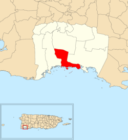 Location of Parguera within the municipality of Lajas shown in red | |
 Parguera Location of Puerto Rico | |
| Coordinates: 17°58′33″N 67°02′31″W[1] | |
| Commonwealth | |
| Municipality | |
| Area | |
| • Total | 7.34 sq mi (19.0 km2) |
| • Land | 4.02 sq mi (10.4 km2) |
| • Water | 3.32 sq mi (8.6 km2) |
| Elevation | 36 ft (11 m) |
| Population (2010) | |
| • Total | 2,082 |
| • Density | 519.2/sq mi (200.5/km2) |
| Source: 2010 Census | |
| Time zone | UTC−4 (AST) |
There is a popular tourist location called La Parguera in the surrounding area.
History
Puerto Rico was ceded by Spain in the aftermath of the Spanish–American War under the terms of the Treaty of Paris of 1898 and became a territory of the United States. In 1899, the United States conducted its first census of Puerto Rico finding that the combined population of Parguera and Costa barrios was 1,256.[4]
| Historical population | |||
|---|---|---|---|
| Census | Pop. | %± | |
| 1980 | 1,677 | — | |
| 1990 | 1,796 | 7.1% | |
| 2000 | 2,071 | 15.3% | |
| 2010 | 2,082 | 0.5% | |
| U.S. Decennial Census[5] 1899 (shown as 1900)[6] 1910-1930[7] 1930-1950[8] 1980-2000[9] 2010[10] | |||
See also
References
- "US Gazetteer 2019". US Census. US Government.
- U.S. Geological Survey Geographic Names Information System: Parguera barrio
- Puerto Rico:2010:population and housing unit counts.pdf (PDF). U.S. Dept. of Commerce, Economics and Statistics Administration, U.S. Census Bureau. 2010.
- Joseph Prentiss Sanger; Henry Gannett; Walter Francis Willcox (1900). Informe sobre el censo de Puerto Rico, 1899, United States. War Dept. Porto Rico Census Office (in Spanish). Imprenta del gobierno. p. 164.
- "U.S. Decennial Census". United States Census Bureau. Archived from the original on 13 February 2020. Retrieved 21 September 2017.
- "Report of the Census of Porto Rico 1899". War Department Office Director Census of Porto Rico. Archived from the original on 16 July 2017. Retrieved 21 September 2017.
- "Table 3-Population of Municipalities: 1930 1920 and 1910" (PDF). United States Census Bureau. Archived (PDF) from the original on 17 August 2017. Retrieved 21 September 2017.
- "Table 4-Area and Population of Municipalities Urban and Rural: 1930 to 1950" (PDF). United States Census Bureau. Archived (PDF) from the original on 30 August 2015. Retrieved 21 September 2014.
- "Table 2 Population and Housing Units: 1960 to 2000" (PDF). United States Census Bureau. Archived (PDF) from the original on 24 July 2017. Retrieved 21 September 2017.
- Puerto Rico:2010:population and housing unit counts.pdf (PDF). U.S. Dept. of Commerce Economics and Statistics Administration U.S. Census Bureau. 2010. Archived (PDF) from the original on 20 February 2017. Retrieved 2 August 2019.
This article is issued from Wikipedia. The text is licensed under Creative Commons - Attribution - Sharealike. Additional terms may apply for the media files.