Parish of Dubbo
Dubbo Parish (Gordon County), is a civil parish of Gordon County, New South Wales.[4] a Cadastral divisions of New South Wales.[5]
| Dubbo Parish New South Wales | |||||||||
|---|---|---|---|---|---|---|---|---|---|
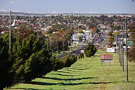 Overlooking Dubbo from the parish | |||||||||
Dubbo Parish | |||||||||
| Coordinates | 32°15′25″S 148°36′4″E | ||||||||
| Postcode(s) | 2830 | ||||||||
| Elevation | 275 m (902 ft)[1][2] | ||||||||
| Time zone | AEST (UTC+10) | ||||||||
| • Summer (DST) | AEDT (UTC+11) | ||||||||
| Location | 400 km (249 mi) NW of Sydney[3] | ||||||||
| LGA(s) | Dubbo Regional Council | ||||||||
| Region | Central West / Orana | ||||||||
| County | Gordon | ||||||||
| State electorate(s) | Dubbo | ||||||||
| Federal Division(s) | Parkes | ||||||||
| |||||||||
The parish, located in Dubbo Regional Council, features the township of West Dubbo, Taronga Western Plains Zoo and Dubbo Observatory. The Burke Railway line passes through the parish. During World War II an airbase was established in the parish.
References
- DCC Annual Report, Dubbo City Council, 2005|accessdate=30
- 2., 28 September 2007 (refer page 7)
- Dubbo Parish lies at a bearing of 307° from Sydney
- Robert McLean, The New atlas of Australia : the complete work containing over one hundred maps and full descriptive geography of New South Wales, Victoria, Queensland, South Australia and Western Australia, together with numerous illustrations and copious indices (Sydney :J. Sands, [1886) Map 141.
- "Gordon County". Geographical Names Register (GNR) of NSW. Geographical Names Board of New South Wales.

This article is issued from Wikipedia. The text is licensed under Creative Commons - Attribution - Sharealike. Additional terms may apply for the media files.