Pennsylvania Route 981
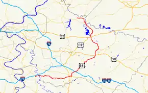
Pennsylvania Route 981 (PA 981) is a state highway which runs 50.4 miles (81.1 km) across Westmoreland County, in southwestern Pennsylvania. The highway begins at PA 51 in Rostraver Township, Pennsylvania, and runs northward across Westmoreland County, passing through the towns of Mount Pleasant, Latrobe, and New Alexandria before ending at PA 819 in Salina.[2]
| ||||
|---|---|---|---|---|
 | ||||
| Route information | ||||
| Maintained by PennDOT | ||||
| Length | 50.483 mi[1] (81.245 km) | |||
| Major junctions | ||||
| South end | ||||
| North end | ||||
| Location | ||||
| Counties | Westmoreland | |||
| Highway system | ||||
| ||||

Route description
PA 981 begins at PA 51 in Rostraver Township. From Rostraver, the route runs eastward to the borough of Mount Pleasant, where it meets PA 31. PA 981 then turns northward, meeting US 30 outside the city of Latrobe, near the Arnold Palmer Regional Airport. The route then continues northward through Latrobe, passing by Saint Vincent College in Latrobe. Continuing northward, PA 981 meets US 119 and US 22 at the borough of New Alexandria. The route then ends at PA 819 near Salina.
History
PA 981 previously ended at PA 156, but was extended in 1998 to its current terminus at PA 819.[3]
PennDOT began construction in 2006 to improve the intersection between PA 981 and US 30 near Latrobe.[4]
Major intersections
The entire route is in Westmoreland County.
| Location | mi[1] | km | Destinations | Notes | |
|---|---|---|---|---|---|
| Rostraver Township | 0.000 | 0.000 | Southern terminus | ||
| Youghiogheny River | 1.594– 1.656 | 2.565– 2.665 | Smithton Low-Level Bridge | ||
| Mount Pleasant | 13.819 | 22.240 | Southern end of PA 31 concurrency | ||
| 14.187 | 22.832 | Northern end of PA 31 concurrency | |||
| Mount Pleasant Township | 15.356 | 24.713 | |||
| Unity Township | 23.061 | 37.113 | Southern end of PA 130 concurrency | ||
| 23.540 | 37.884 | Northern end of PA 130 concurrency | |||
| 28.273 | 45.501 | ||||
| Derry Township | 38.169 | 61.427 | |||
| Loyalhanna Township | 45.892 | 73.856 | Southern end of PA 286 concurrency | ||
| 46.090 | 74.175 | Northern end of PA 286 concurrency | |||
| Bell Township | 48.594 | 78.204 | Southern terminus of PA 156 | ||
| 50.483 | 81.245 | Northern terminus | |||
1.000 mi = 1.609 km; 1.000 km = 0.621 mi
| |||||
See also
 U.S. Roads portal
 Pennsylvania portal
References
| Wikimedia Commons has media related to Pennsylvania Route 981. |
- Bureau of Maintenance and Operations (January 2015). Roadway Management System Straight Line Diagrams (Report) (2015 ed.). Pennsylvania Department of Transportation. Archived from the original on February 17, 2011. Retrieved June 30, 2015.
- Westmoreland County Archived 2011-02-17 at Wikiwix (PDF)
- Google (February 15, 2014). "Pennsylvania Route 981" (Map). Google Maps. Google. Retrieved February 15, 2014.
- Pennsylvania Highways: Route 981
- PennDOT: State Route 981 and U.S. 30 Improvements Project Archived February 13, 2008, at the Wayback Machine