Perm Governorate
Perm Governorate (Russian: Пермская губерния) was an administrative unit of the Russian Empire and the Soviet Union from 1781 to 1923. It was located on both slopes of the Ural Mountains, and its administrative center was the city of Perm. The region gave its name to the Permian period.
| Perm Governorate Пермская губерния | |||||||||
|---|---|---|---|---|---|---|---|---|---|
| Governorate of Russian Empire, Russian Republic, Soviet Russia | |||||||||
| 1781–1923 | |||||||||
.svg.png.webp) Location in the Russian Empire | |||||||||
| Capital | Perm | ||||||||
| Area | |||||||||
• (1897) | 332,052 km2 (128,206 sq mi) | ||||||||
| Population | |||||||||
• (1897) | 2994302 | ||||||||
| History | |||||||||
• Established | 1781 | ||||||||
• Disestablished | November 3 1923 | ||||||||
| Political subdivisions | uezds: 12 | ||||||||
| |||||||||
.svg.png.webp)
History
On November 20 (December 1), 1780, Catherine II signed a decree establishing the governorship of Perm in the two regions – Perm and Yekaterinburg, and the establishment of the provincial city of Perm. The first Governor-General of Perm and Tobol regions was appointed Lieutenant-General Yevgeny Petrovich Kashkin. In accordance with the decree of Emperor Paul I of December 12, 1796 "A new division of the state in the province", Perm and Tobolsk governor-generalship was divided in Perm and Tobolsk Governorates. On July 15, 1919, from the Perm province has been allocated Yekaterinburg Governorate, consisting of 6 uyezds, located in the east, beyond the Urals. On November 4, 1920, its membership was included Sarapulsky Uyezd of Vyatka Governorate. On November 3, 1923, Perm province was abolished and its territory was included in the Ural Oblast with its center in Yekaterinburg.
Geography
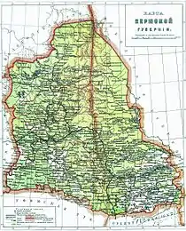
Perm Governorate was bordered with Vologda Governorate (to the north), Tobolsk Governorate (to the east), Orenburg and Ufa governorates (to the south) and Vyatka Governorate (to the west). Governorate's area was 332,052 km², 181,000 of them – in Europe and 151,000 – in Asia. Ural mountains, that crossed governorate from north to south for 640 km was a border between European and Asian parts. Highest point of governorate was Konzhakovsky Kamen (1565 m). European part of Perm governorate situated in basin of Kama River, Asian part – in basin of Tobol River. Drainage basin of Pechora River occupied extreme north of Cherdynsky Uyezd.
Administrative division
Perm Governorate was divided into 12 uyezds.
European part:
- Permsky Uyezd
- Krasnoufimsky Uyezd
- Kungursky Uyezd
- Osinsky Uyezd
- Okhansky Uyezd
- Solikamsky Uyezd
- Cherdynsky Uyezd
Asian part:
Population
In early 19th century, population of the governorate was approx. 940,000. According 1896 data, population of region was 2,968,472 (1,433,231 of them are male and 1,535,211 are female). According to the 1897 Census, population was 2,994,302.
Major cities were:
- Perm: 45,205
- Yekaterinburg: 43,239
- Irbit: 20,062
According 1897 Census, for 90.3% of governorate's population used Russian as their native language, 3.1% used Komi-permyak language, 2.9% – Bashkir language, 1.6% – Tatar language.[1] Most of population was Orthodox Christians with Old Believers (7.29%) and Muslim (5.06%) minorities.
Economy
The economy of governorate was based on industry, however in some parts of region prevailed agriculture sector. Arable lands was 33,000 km2 (approx. 9.53% of total area). Main crops were: rye, oat and barley. Wheat was cultivated mostly in southern areas. Livestock breeding was well developed in Shadrinsky Uyezd, among Bashkir people. Despite of plenty of rivers, fishing was developed only in Cherdynsky Uyezd. Commercial hunting was also only in the north of region, in Cherdynsky Uyezd.
Industry was based by mining, main minerals included copper, iron ore, gold, coal and salt. Most of mining and metallurgical plants was situated in central part of Ural Mountains. The Perm Governorate was well connected by railroads with other regions of Russian Empire. Main rivers also had great transport significance.