Phlapphla Chai
Phlapphla Chai (Thai: พลับพลาไชย, pronounced [pʰláp.pʰlāː t͡ɕʰāj]) is a road in Bangkok's Pom Prap and Wat Thep Sirin sub-districts, Pom Prap Sattru Phai District and also the five-way intersection of the road with Luang and Maitri Chit Roads. It is also the name of the surrounding area and considered as a part of Bangkok's Chinatown.
The Road
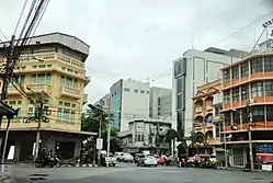
Phlapphla Chai Road separates from the left side of Charoen Krung Road at Plaeng Nam Intersection, extending and running north, cutting with Luang and Maitri Chit Roads at Phlapphla Chai Intersection and continue north as far as it reaches Bamrung Mueang Road in the Suan Mali quarter, with a total distance about 1.1 km (0.68 mi).
BMTA's bus line 53 (inner city loop) is the only one running on this road (only section between Phlapphla Chai Intersection and the road end).
Bordering the road are Li Ti Meow Shrine, Wat Khanikaphon, Poh Teck Tung Foundation, Phlapphla Chai Police Station 1 and 2, Tai Hong Kong Shrine, and Wat Thepsirin.
History
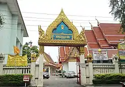
The name Phlapphla Chai comes from Wat Phlapphla Chai (วัดพลับพลาไชย), a wat (Thai temple) site on the corner of intersection. The temple was built in the Ayutthaya period. For the name Wat Phlapphla Chai is the new name instead of Wat Khok (วัดโคก). The name Wat Phalpphla Chai was derived from the reason that this area used to be the site for setting up Phlapphla (pavilion) of King Phutthayotfa Chulalok (Rama I) since he was Chao Phraya Maha Kasat Suek (his highest title before the reigned) and coming back after overcome the war against the Khmers in 1782. Phlappla Chai Road was not built straight, because there was Meng Soon Building as an obstacle. The building's owner was under protection of France's extra territorial rights and he did not allow his land to be expropriated. The road therefore had to inevitably detoured the bypass of his land. It was built in the reign of King Chulalongkorn (Rama V).
The area around the temple used to be the site of the convict execution ground in the old days, assuming from the plenty of human skeletons was found.
In addition, the edge of the temple was also location of Pom Prap Sattru Phai. One of the eight forts built along canal Khlong Phadung Krung Kasem in the reign of King Mongkut (Rama IV), it became the name of the present Pom Prap Sattru Phai District.[1]
In the reign of King Vajiravudh (Rama VI), it was used as a practice field for the Wild Tiger Corps, his personal affairs and he gave it the new name of Wat Phlapphla Chai, which translates to 'Victory Pavilion Temple', alluding to the pavilion built for the King Phutthayotfa Chulalok inside the temple.
In the evening on 3 July 1974, Phlapphla Chai was the site of the "Chinatown Riots",[2] which left 26 dead and more than 120 injured. The riots started when two police officers arrested a taxi driver for illegal parking. He resisted and yelled that they were beating me. His yelling caused crowds to gather at Phlapphla Chai Police Station, eventually escalating into a riot and spread to nearby areas such as Hua Lamphong, July 22nd Circle, King Chulalongkorn Memorial Hospital, Rama IV Road, Wang Burapha. Protesters burned public places, threw bombs, and fired at police officers, who were unable to control the situation. The riots continued for four days until the government of prime minister Sanya Dharmasakti declared a state of emergency. The incident finally ended after soldiers and police used force to quell the rioters. The incident is considered to the first people's uprising since the Oct 14 event last year.[3]
Phlapphla Chai is one of the areas most populated by those of Thai Chinese descent. It is not far from Yaowarat or Charoen Krung Roads and contains a number of restaurants and street food vendors in the surrounding area. Some of them were chosen to be Bib Gourmand from Michelin Guide as well.[2][3][4][5][6] In addition, in the past it was known as the centre of photography equipment stores.
References
- Wongthes, Sujit (2016-06-14). "คลองผดุงกรุงเกษม ส่วนขยายของกรุงเทพฯ สมัย ร.4" [Phadung Krung Kasem Canal the extension of Bongkok in the Rama IV's reign]. Matichon (in Thai). Retrieved 2021-01-11.
- Kasetsiri, Charnvit (2012). Thailand Timeline 1942-2011 (in Thai). Bangkok: Post Books. ISBN 9789742280703.
- Bunnag, Rome (2016-04-11). "น้ำผึ้งหยดเดียว! แค่ ตร.จราจรจับแท็กซี่ กลายเป็นจลาจลจน ตร.รับไม่ไหว ต้องประกาศภาวะฉุกเฉิน ส่งรถถังเข้าปราบ!!" [Make a mountain out of a molehill! just a traffic police to arrest a taxi became a riot until the police couldn't control must to declare a state of emergency send a tank to defeat!!]. Manager Daily (in Thai).
- "ไหว้พระทำบุญ เยี่ยมชุมชนคนจีน ที่ "ย่านพลับพลาไชย"" [Pay homage visit Chinatown at "Phlapphla Chai neighbourhood"]. Manager Daily (in Thai). 2015-01-23.
- "Poon Lert Room (Phlapphla Chai intersection)". Michelin Guide.
- "Ann Guay Tiew Kua Gai". Michelin Guide.