Pic Ramougn
Pic Ramougn (3,011 m) is a steep, rocky mountain in the Néouvielle massif in the Pyrenees.
| Pic Ramougn | |
|---|---|
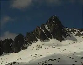 North side of Pic Ramougn from Hourquette d'Aubert | |
| Highest point | |
| Elevation | 3,011 m (9,879 ft) |
| Prominence | 60 m (200 ft) |
| Coordinates | 42°50′06″N 00°07′12″E |
| Geography | |
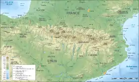 Pic Ramougn Location in the Pyrenees | |
| Location | Hautes-Pyrénées, France |
| Parent range | Pyrenees |
| Geology | |
| Mountain type | Granite |
It is located in the commune of Saint-Lary-Soulan within the department of the Hautes-Pyrénées, and is named after the French politician, geologist and botanist Louis Ramond de Carbonnières. Ramougn is the pronunciation of Ramond in the Gascon language.
External links
This article is issued from Wikipedia. The text is licensed under Creative Commons - Attribution - Sharealike. Additional terms may apply for the media files.