Pic de Rochebrune
The Pic de Rochebrune (or Grand Rochebrune or, simply, Rochebrune) is a mountain in the Cottian Alps belonging to the French department of Hautes-Alpes.
| Pic de Rochebrune | |
|---|---|
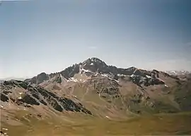 Pic de Rochebrune: eastern slopes | |
| Highest point | |
| Elevation | 3,320 m (10,890 ft) [1] |
| Prominence | 1,019 m (3,343 ft) [1][2] |
| Listing | Alpine mountains above 3000 m |
| Coordinates | 44°49′21″N 06°47′14″E |
| Geography | |
 Pic de Rochebrune Alps | |
| Location | Provence-Alpes-Côte d'Azur, France |
| Parent range | Cottian Alps |
| Climbing | |
| Easiest route | from col d'Izoard[3] |
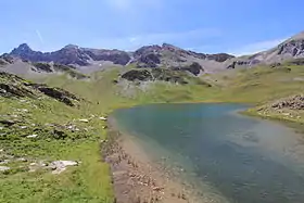
Northern slopes of the Pic de Rochebrune as seen from the Lac des Cordes
Etymology
The literal English translation of Pic de Rochebrune can be dark rock peak or brown rock peak.
Geography
The mountain is the highest summit of the Central Cottian Alps.
Nature conservation
The Pic de Rochebrune is located on the northern border of the regional nature park of Queyras (Parc naturel régional du Queyras ), established in 1977.[4]
Access to the summit
The easiest route to reach the summit starts from the Izoard pass. It requires some climbing skills. [3]
Pic de Rochebrune
References
- Pic de Rochebrune, France, on www.peakbagger.com (access: May 2012)
- Key col:Colle della Croce
- Grand Rochebrune, route description on www.summitpost.org
- Histoire, web page on the nature park site www.pnr-queyras.com Archived 2008-11-12 at the Wayback Machine (accessed in Mayl 2012)
Maps
- French official cartography (Institut géographique national - IGN); on-line version: www.geoportail.fr
See also
This article is issued from Wikipedia. The text is licensed under Creative Commons - Attribution - Sharealike. Additional terms may apply for the media files.