Pinconning River
The Pinconning River (Ojibwe Opinikaaning-ziibi (syncope as Pinkaaning-ziibi), "River at potatoing-grounds")[3] is a small river on the central Lower Peninsula of Michigan in the United States. It is 15.6 miles (25.1 km) long[4] and flows to Saginaw Bay of Lake Huron, draining an area of 26.6 square miles (69 km2).[5] Via Lake Huron and the Great Lakes system, it is part of the larger watershed of the St. Lawrence River.
| Pinconning River | |
|---|---|
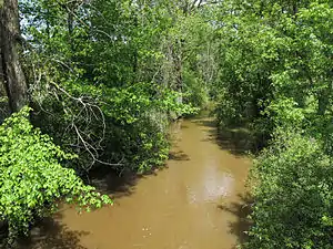 The Pinconning River in Pinconning Township | |
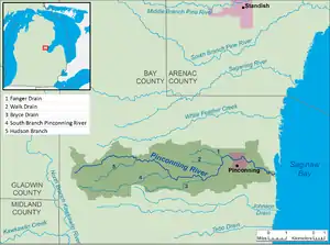 A map of the Pinconning River and its watershed. | |
| Native name | Opinikaakiing-ziibi |
| Location | |
| Country | United States |
| State | Michigan |
| County | Bay |
| Townships | Mount Forest, Pinconning |
| Municipality | Pinconning |
| Physical characteristics | |
| Source | |
| • location | Mount Forest Township |
| • coordinates | 43.8483564°N 84.1497153°W[1] |
| • elevation | 679 ft (207 m)[2] |
| Mouth | Saginaw Bay |
• location | Pinconning Township |
• coordinates | 43.8469655°N 83.9208187°W[1] |
• elevation | 577 ft (176 m)[1] |
| Length | 10.9 mi (17.5 km) |
| Basin size | 26.6 sq mi (69 km2) |
| Basin features | |
| Hydrologic Unit Code | 040801020107 (USGS) |
The Pinconning River's course and watershed are entirely in northern Bay County. It begins in Mount Forest Township, approximately 9.4 miles (15.1 km) west of the city of Pinconning, and flows generally eastward, through Pinconning Township and Pinconning. It flows into Saginaw Bay in Pinconning Township, approximately 2.2 miles (3.5 km) east of Pinconning.[6] Its largest tributary is the South Branch Pinconning River,[7] which is 6.2 miles (10.0 km) long and flows into the Pinconning River upstream of Pinconning.[6]
The Saginaw Bay Land Conservancy owns a nature preserve, the Pinconning Nature Preserve, along the river in Pinconning Township.[8] Bay County operates a county park, Pinconning Park, on the north bank of the river at its mouth.[9]
Tributaries
This is a list of named streams in the Pinconning River's watershed, as identified by the National Hydrography Dataset. All are direct tributaries of the Pinconning River. By default, the list is ordered from the mouth of the river to its source.
| Name | Length[4] | |
|---|---|---|
| 1 | Fanger Drain[10] | 2.4 miles (3.9 km) |
| 2 | Walk Drain[11] | 1.8 miles (2.9 km) |
| 3 | Bryce Drain[12] | 4.1 miles (6.6 km) |
| 4 | South Branch Pinconning River[7] | 6.2 miles (10.0 km) |
| 5 | Hudson Branch[13] | 3.3 miles (5.3 km) |
See also
References
- Geographic Names Information System. "Geographic Names Information System entry for Pinconning River (Feature ID #634901)". Retrieved 2015-08-05.
- The National Map elevation query for coordinates given in cited GNIS record, http://viewer.nationalmap.gov/viewer/. Retrieved on 2015-08-05.
- "City of Pinconning—Cheese Capital of Michigan: History".
- U.S. Geological Survey. National Hydrography Dataset high-resolution flowline data. The National Map, retrieved 2015-08-05.
- U.S. Geological Survey. National Hydrography Dataset, area data for Pinconning River watershed, 12-digit Hydrologic Unit Code 040801020107. The National Map, retrieved 2015-08-05
- The National Map, accessed 2015-08-05.
- Geographic Names Information System. "Geographic Names Information System entry for South Branch Pinconning River (Feature ID #638302)". Retrieved 2015-08-05.
- "Pinconning Nature Preserve". Archived from the original on 2015-06-12. Retrieved 2015-08-05.
- "Bay County Pinconning Park". Archived from the original on 2015-04-08. Retrieved 2015-08-05.
- U.S. Geological Survey Geographic Names Information System: Fanger Drain
- U.S. Geological Survey Geographic Names Information System: Walk Drain
- U.S. Geological Survey Geographic Names Information System: Bryce Drain
- U.S. Geological Survey Geographic Names Information System: Hudson Branch