Pizzo Erra
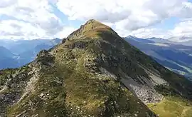
Pizzo Erra is a mountain of the Lepontine Alps, located in the Swiss canton of Ticino. It is located south of the pass of Basso di Nara, on the subrange that separates the main valley of Leventina from the valley of Blenio. At 2,416 metres (7,927 ft) above sea level, its summit can be accessed with trails from both western and eastern side.
| Pizzo Erra | |
|---|---|
 | |
| Highest point | |
| Elevation | 2,416 m (7,927 ft) |
| Prominence | 300 m (980 ft) [1] |
| Parent peak | Piz Gannaretsch |
| Isolation | 5.54 km (3.44 mi) |
| Coordinates | 46°26′27.9″N 8°53′27.4″E |
| Geography | |
 Pizzo Erra Location in Switzerland | |
| Location | Ticino, Switzerland |
| Parent range | Lepontine Alps |
References
- Retrieved from the Swisstopo topographic maps. The key col is the Bassa di Laghetto (2,116 m).
This article is issued from Wikipedia. The text is licensed under Creative Commons - Attribution - Sharealike. Additional terms may apply for the media files.