Plattenberg
The Plattenberg is a mountain of the Lepontine Alps, located on the border between the Swiss cantons of Ticino and Graubünden. It lies approximately halfway between the lakes of Luzzone and Zervreila.
| Plattenberg | |
|---|---|
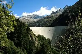 The Plattenberg (centre-left) from the Luzzone dam | |
| Highest point | |
| Elevation | 3,041 m (9,977 ft) |
| Prominence | 59 m (194 ft) [1] |
| Parent peak | Vernokhörner |
| Coordinates | 46°33′29.9″N 9°1′24.3″E |
| Geography | |
 Plattenberg Location in Switzerland | |
| Location | Ticino/Graubünden, Switzerland |
| Parent range | Lepontine Alps |
References
- Retrieved from the Swisstopo topographic maps. The key col is located north of the summit at 2,982 metres.
This article is issued from Wikipedia. The text is licensed under Creative Commons - Attribution - Sharealike. Additional terms may apply for the media files.