Pokaka railway station
Pokaka was a station on the North Island Main Trunk line,[1] in the Ruapehu District of New Zealand. It served the small village of Pokaka and lay to the south of Makatote Viaduct, the late completion of which held up opening of the station.
Pokaka railway station | |||||||||||
|---|---|---|---|---|---|---|---|---|---|---|---|
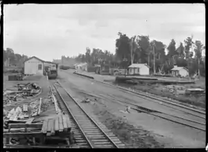 Pokaka circa 1924, still with Pokako name | |||||||||||
| Location | New Zealand | ||||||||||
| Coordinates | 39.292489°S 175.390314°E | ||||||||||
| Elevation | 811 m (2,661 ft) | ||||||||||
| Line(s) | North Island Main Trunk | ||||||||||
| Distance | Wellington 332.77 km (206.77 mi) | ||||||||||
| History | |||||||||||
| Opened | in use from 20 March 1908 | ||||||||||
| Closed | 1 September 1971 | ||||||||||
| Electrified | June 1988 | ||||||||||
| Previous names | to 29 July 1922 was Pokako | ||||||||||
| Services | |||||||||||
| |||||||||||
Name
Pokako was changed to Pokaka in 1922, to "correct spelling",[2] though both names seem to be used, at least from 1905[3] to 1945.[4]
History
Surveying for the route between Hīhītahi and Piriaka began in 1894.[5] Work on the station building began in November 1908.[6] A 6th class station was built by March 1909, with a 23 ft (7.0 m) by 11 ft (3.4 m) shelter shed, lobby, store and urinals on a 200 ft (61 m) by 15 ft (4.6 m) platform, a 20 ft (6.1 m) by 30 ft (9.1 m) goods shed, a loading bank, cattle and sheep yards and a cart approach. Pokaka was described as a tablet station from 1908 and a tablet porter was appointed in 1912. A loop could take 57 wagons, until closed on 13 September 1986,[2] prior to electrification. There is now only a single line through the former station site.[7]
The station closed to goods traffic in wagon lots on 21 August 1965 and to all traffic on 1 September 1971.[2]
Timber
Like the other stations along this part of NIMT, Pokaka had freight from several timber mills. Tiratu Sawmill Co applied for a private siding in 1920.[8] Pokaka Timber Co still had a private siding in 1943,[2] which ran to the west of the railway, probably from about 1935 to 1957. To the east,[9] to supply timber to the Frankton Junction Railway House Factory, a state forestry tramway[10] and sawmill opened in 1922[11] It closed about 1927,[12] or 1928.[13] In 1922 Manawatu-Oroua Electric Power Board and Manawatu CC took over cutting of manoao[14] for poles, though larger trees were milled into sleepers.[15] A tramway was laid in 1923.[16] A tramway to the Mangaturuturu valley was still in use in 1938.[17]
Last Spike Monument
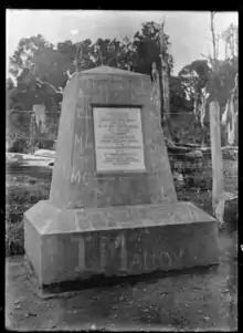
In early 1909 a concrete obelisk[18] was erected to mark when Prime Minister, Sir Joseph Ward, conducted a last spike ceremony on 6 November 1908.[19] A silver-plated spike was used, though the actual last spike was driven in about 300 m (980 ft) to the south, to complete work on the Manganui-o-te-Ao viaduct,[18] where temporary tracks met on 3 August 1908. The monument was four-sided, 6 ft (1.8 m) high and 4 ft (1.2 m) across the base, with black lettering on a white marble slab. It was about 20 ft (6.1 m) to the west of the line,[19] but moved a further 10 ft (3.0 m) west in 1973. In 1997 the Institution of Professional Engineers New Zealand put two new brass inscription plates on the monument.[18] It is now marked by road signs on SH4 and a small carpark.[20]
Manganui o te Ao viaduct | |
|---|---|
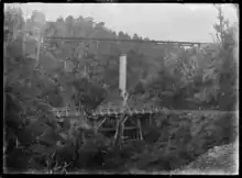 Manganui o te Ao Viaduct and road bridge in 1921 | |
| Coordinates | 39.27878°S 175.38931°E |
| Carries | Single track of the North Island Main Trunk |
| Crosses | Hapuawhenua Stream |
| Owner | KiwiRail |
| Characteristics | |
| Total length | 290 feet (88 m) |
| Height | 112 feet (34 m) |
| History | |
| Engineering design by | Andersons |
| Construction start | 1906 |
| Construction end | April 1908 |
| Replaced by | 1967 reinforced concrete, 91 m (299 ft) long viaduct |
Viaducts
Makatote and Manganui o te Ao viaducts are north of Pokaka and Mangaturuturu just south. They take the line over the Makatote, Manganui o te Ao and Mangaturuturu valleys, which descend steeply from Mount Ruapehu. All were designed by Peter Seton Hay and supervised by Resident Engineer, Frederick William Furkert. The concrete foundations and piers were built by the Public Works Department,[21] but as PWD's Mangaonoho workshop was at full capacity on the more southerly viaducts,[22] their steelwork was built by Christchurch firm, J. & A. Anderson & Co, who also built Waiteti and Makotuku viaducts.[23]
Both viaducts were made up of a central concrete pier, supporting Warren truss steel girders and built using timber scaffolding.[24] Like most NIMT viaducts, they were strengthened between 1925 and 1932, in preparation for the heavier K Class locos.[25]
Manganui o te Ao Viaduct
Over a kilometre north of Pokaka,[26] Manganui o te Ao Viaduct is a straight viaduct, 290 ft (88 m) long and up to 112 ft (34 m) above Manganui o te Ao River, supported by a single concrete pier.[27] Each 1908 girder was 122 ft (37 m) long, with 230 tons of steel in the bridge,[28] costing £8,840.[29] The original viaduct was replaced in 1967,[24] or 1964, by a slightly longer 91 m (299 ft) reinforced and pre-stressed concrete viaduct.[30]
Mangaturuturu viaduct | |
|---|---|
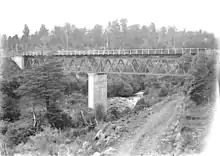 Mangaturuturu viaduct in 1921 | |
| Coordinates | 39.30467°S 175.38987°E |
| Carries | Single track of the North Island Main Trunk |
| Crosses | Mangaturuturu River |
| Owner | KiwiRail |
| Characteristics | |
| Design | concrete pier, two 30 metres (98 ft) steel Warren trusses. |
| Material | Steel |
| Total length | 60 metres (200 ft) |
| Height | 18 metres (59 ft) |
| No. of spans | 2 |
| History | |
| Engineering design by | Andersons |
| Constructed by | PWD |
| Construction start | 1907 |
| Construction end | June 1908 |
| Designated | 20 February 2009 |
| Reference no. | 7779 |
| Location | |

| |
Mangaturuturu Viaduct
Just over a kilometre south of Pokaka,[31] Mangaturuturu Viaduct is longer, but lower, being 61 m (200 ft) long[9] and up to 60 ft (18 m) high.[32] Each girder is 98 ft (30 m) long. It is one of the few viaducts surviving from the construction era and was therefore listed in 2009. Repairs and replacements included the rail beams in 1958, 1987, 2005 and 2008, bolts in 1962 and repainting in 1979 and 2005. In 1971 the central pier was underpinned and vertically pre-stressed. In 1975 it withstood a lahar, which raised the river to 2.1 m (6 ft 11 in) above its flood level.[25]
References
- Scoble, Juliet. "Names & Opening & Closing Dates of Railway Stations in New Zealand 1863 to 2010" (PDF). Rail Heritage Trust of New Zealand.
- "Stations" (PDF). NZR Rolling Stock Lists. Retrieved 2020-08-10.
- "RANGITIKEI COUNTY COUNCIL. WANGANUI CHRONICLE". paperspast.natlib.govt.nz. 10 Jul 1905. Retrieved 2020-12-25.
- "LABOUR GOVERNMENT. MANAWATU STANDARD". paperspast.natlib.govt.nz. 22 Nov 1945. Retrieved 2020-12-25.
- "THE RAURIMU SPIRAL. NEW ZEALAND HERALD". paperspast.natlib.govt.nz. 1 Nov 1929. Retrieved 2020-10-11.
- "MAIN TRUNK LINE. MANAWATU HERALD". paperspast.natlib.govt.nz. 26 Nov 1908. Retrieved 2020-11-22.
- "Manawatū Whanganui 0.3m Rural Aerial Photos (2016-2017)". basemaps.linz.govt.nz. Retrieved 2020-12-25.
- "LOCAL AND GENERAL. MANAWATU TIMES". paperspast.natlib.govt.nz. 28 Jun 1920. Retrieved 2020-12-26.
- New Zealand Railway and Tramway Atlas (Fourth ed.). Quail Map Co. 1993. ISBN 0-900609-92-3.
- "MANAWATU STANDARD". paperspast.natlib.govt.nz. 1 Sep 1922. Retrieved 2020-12-26.
- "MANAWATU COUNTY. FEILDING STAR". paperspast.natlib.govt.nz. 6 Dec 1922. Retrieved 2020-12-26.
- "BUSH WORKERS. EVENING POST". paperspast.natlib.govt.nz. 11 Apr 1927. Retrieved 2020-12-24.
- "LOGGING AT POKAKA. AUCKLAND STAR". paperspast.natlib.govt.nz. 22 Mar 1928. Retrieved 2020-12-26.
- "HARDWOOD POLES. MANAWATU STANDARD". paperspast.natlib.govt.nz. 6 Oct 1922. Retrieved 2020-12-30.
- "HYDRO-ELECTRICITY. MANAWATU TIMES". paperspast.natlib.govt.nz. 10 Nov 1925. Retrieved 2020-12-30.
- "LOCAL AND GENERAL. MANAWATU TIMES". paperspast.natlib.govt.nz. 13 Mar 1923. Retrieved 2020-12-30.
- "DEPARTMENT OF LANDS AND SURVEY. PUBLIC DOMAINS AND NATIONAL PARKS OF NEW ZEALAND". paperspast.natlib.govt.nz. 1 Aug 1939. Retrieved 2020-12-20.
- "North Island Main Trunk Line 'Last Spike' Memorial". www.heritage.org.nz. Retrieved 2020-12-26.
- "THE AEROPLANE. WANGANUI HERALD". paperspast.natlib.govt.nz. 25 Feb 1909. Retrieved 2020-12-26.
- "Volcanic Loop Hwy". Google Maps. Retrieved 2020-12-30.
- Parliament, New Zealand (1907). Parliamentary Debates.
- "Taonui Viaduct". www.heritage.org.nz. Retrieved 2020-11-28.
- "North Island Main Trunk (NIMT) Historic Area". www.heritage.org.nz. Retrieved 2019-02-01.
- "Mangaturuturu Viaduct". www.heritage.org.nz. Retrieved 2020-12-27.
- "Mangaturuturu Viaduct". www.heritage.org.nz. Retrieved 2020-12-28.
- "Manganuioteao Viaduct, Manawatu-Wanganui". NZ Topo Map. Retrieved 2020-12-26.
- "In the heart of the North Island Bush Country. — (Rly. Publicity photo.)". nzetc.victoria.ac.nz. Retrieved 2020-12-26.
- "PUBLIC WORKS STATEMENT. BY THE HON. WILLIAM HALL-JONES, MINISTER OF PUBLIC WORKS". paperspast.natlib.govt.nz. 22 Sep 1908. Retrieved 2020-12-27.
- "PUBLIC WORKS STATEMENT. BY THE HON. W. HALL-JONES, MINISTER FOR PUBLIC WORKS". paperspast.natlib.govt.nz. 19 Oct 1906. Retrieved 2020-12-27.
- New Zealand Railway and Tramway Atlas (Fourth ed.). Quail Map Co. 1993. ISBN 0-900609-92-3.
- "Mangaturuturu Viaduct, Manawatu-Wanganui". NZ Topo Map. Retrieved 2020-12-26.
- "PUBLIC WORKS STATEMENT. BY THE HON. WILLIAM HALL-JONES, MINISTER OF PUBLIC WORKS". paperspast.natlib.govt.nz. 22 Sep 1908. Retrieved 2020-12-27.
External links
Photos -
- Last Spike Obelisk in 1913
- goods train crossing the Manganui-a-te-Ao Viaduct in 1913
- log being loaded by overhead gear onto F class locomotive 255 at Pokaka Bush ca 1928-1929
- 1947 aerial view of railway station
- 3 December 1966 crash at Pokaka