Puliyanthivu
Puliyanthivu (Tamil: புளியந்தீவு) is an island of Sri Lanka and part of Batticaloa town. It has important infrastructures such as government buildings (District Secretariat. Municipal council, Post office, Public library, Teaching hospital, Bus stand, etc.), banks, schools, religious worship places and historical importance places, notably Batticaloa Fort.[1]
Puliyanthivu
புளியந்தீவு කොටිදූව | |
|---|---|
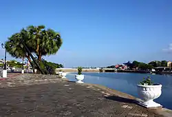 This area was colonial port | |
| Coordinates: 7°42′45.39″N 81°41′49.33″E | |
| Country | Sri Lanka |
| Province | Eastern |
| District | Batticaloa |
| Divisional Secretariat | Manmunai North |
| Native name: புளியந்தீவு කොටිදූව | |
|---|---|
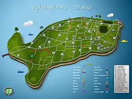 Puliyanthivu in 3D map | |
| Geography | |
| Location | Batticaloa Lagoon |
| Administration | |
| District | Batticaloa District |
| City | Batticaloa |
| Demographics | |
| Population | 7,034 |
Etymology
Batticaloa historical book Mattakalapputh Thamilakam quotes from Swami Vipulananda that Vedda’s chieftain Puliyan ruled the area and his name later adapted to the island. Puliyanthivu literally means "island of Puliyan" (thivu means island). Also, the book quotes from Mahavamsa that there was a caste called Pulinthar, which could be the reason for the name of island. As per the common naming of villages in Batticaloa, which called by name of tree and pond, the island could have been used the name of tree tamarind, since there was a lot of tamarind trees in the area. Tamarind is called Puli in Tamil. Literally, it means "island of tamarind".[2]
History
In the 11th century, one the minister among seven ministers of king Kathirsuthan of Chola dynasty was ruled the area, and the minister name was Pulimaran.[3]
References
- Puliyanthivu
- V. C. Kandaiya (1964). Mattakalapputh Thamilakam (மட்டக்களப்புத் தமிழகம்). pp. 390, 391.
- V. C. Kandaiya (1964). Mattakalapputh Thamilakam (மட்டக்களப்புத் தமிழகம்). p. 414.