Røldal (municipality)
Røldal is a former municipality in the southeastern corner of the old Hordaland county, Norway. The 719-square-kilometre (278 sq mi) municipality existed from 1838 until 1964 and it was located in the southeastern part of the present-day Ullensvang Municipality. The administrative centre was the village of Røldal, where the Røldal Stave Church is located. The municipality encompassed the Røldalen valley and some small side valleys, as well as a large area up on the vast Hardangervidda plateau. Historically, Røldal was an important trade and transportation route between Eastern and Western Norway.[2]
Røldal herad | |
|---|---|
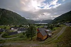 View of the Røldal area | |
 Hordaland within Norway | |
 Røldal within Hordaland | |
| Coordinates: 59°50′00″N 06°48′53″E | |
| Country | Norway |
| County | Hordaland |
| District | Hardanger |
| Established | 1 Jan 1838 |
| Disestablished | 1 Jan 1964 |
| Administrative centre | Røldal |
| Area | |
| • Total | 719 km2 (278 sq mi) |
| *Area at municipal dissolution. | |
| Population (1963) | |
| • Total | 676 |
| • Density | 0.94/km2 (2.4/sq mi) |
| Demonym(s) | Røldøl[1] |
| Time zone | UTC+01:00 (CET) |
| • Summer (DST) | UTC+02:00 (CEST) |
| ISO 3166 code | NO-1229 |
| Created as | Formannskapsdistrikt in 1838 |
| Succeeded by | Odda in 1964 |
History
Historically, the Røldal area was part of the parish of Suldal (to the south), with Røldal being an annex to the main parish. Suldal and Røldal each had their own churches, but they shared a priest since Røldal was a sparsely populated area and could not support their own priest. Suldal was located in Stavanger county and Røldal was located in Søndre Bergenhus county.
This arrangement was not a problem until 1837 when the formannskapsdistrikt law was passed. The law called for each parish to become a municipality led by a self-governing council. It also said that each municipality must be within one county, not two. Therefore, Suldal and Røldal had to be divided and starting on 1 January 1838, Røldal became its own municipality in Søndre Bergenhus county. During the 1960s, there were many municipal mergers across Norway due to the work of the Schei Committee. The sparsely-populated municipality existed until 1 January 1964 when Røldal (population: 676) was merged into the larger neighboring municipality of Odda (population: 9,487).[3]
Municipal council
The municipal council (Heradsstyre) of Kinsarvik is made up of 13 representatives that were elected to four year terms. The party breakdown of the final municipal council was as follows:
| Party Name (in Nynorsk) | Number of representatives | |
|---|---|---|
| Labour Party (Arbeidarpartiet) | 5 | |
| Centre Party (Senterpartiet) | 3 | |
| Liberal Party (Venstre) | 5 | |
| Total number of members: | 13 | |
| Party Name (in Nynorsk) | Number of representatives | |
|---|---|---|
| Labour Party (Arbeidarpartiet) | 5 | |
| Farmers' Party (Bondepartiet) | 4 | |
| Liberal Party (Venstre) | 4 | |
| Total number of members: | 13 | |
| Party Name (in Nynorsk) | Number of representatives | |
|---|---|---|
| Labour Party (Arbeidarpartiet) | 5 | |
| Farmers' Party (Bondepartiet) | 4 | |
| Liberal Party (Venstre) | 1 | |
| Joint List(s) of Non-Socialist Parties (Borgarlege Felleslister) | 2 | |
| Total number of members: | 12 | |
| Party Name (in Nynorsk) | Number of representatives | |
|---|---|---|
| Labour Party (Arbeidarpartiet) | 4 | |
| Farmers' Party (Bondepartiet) | 4 | |
| Liberal Party (Venstre) | 4 | |
| Total number of members: | 12 | |
| Party Name (in Nynorsk) | Number of representatives | |
|---|---|---|
| Labour Party (Arbeidarpartiet) | 5 | |
| Liberal Party (Venstre) | 2 | |
| Joint List(s) of Non-Socialist Parties (Borgarlege Felleslister) | 5 | |
| Total number of members: | 12 | |
Name
The municipality was named after the main village in the parish, Røldal. The village in turn was named after the valley in which it is located. The Old Norse form of the name might have been Rœrgudalr. The first element would then be the genitive case of the local rivername Røyrga (derived from røyrr which means 'rocky ground') and the last element is dalr which means 'dale' or 'valley'.[9]
References
- "Navn på steder og personer: Innbyggjarnamn" (in Norwegian). Språkrådet.
- Store norske leksikon. "Røldal. – kommune" (in Norwegian). Retrieved 2014-06-07.
- Jukvam, Dag (1999). "Historisk oversikt over endringer i kommune- og fylkesinndelingen" (PDF) (in Norwegian). Statistisk sentralbyrå.
- "Kommunevalgene og Ordførervalgene 1959" (PDF). Oslo: Statistisk sentralbyrå. 1960. Retrieved 2020-02-13. Cite journal requires
|journal=(help) - "Kommunevalgene og Ordførervalgene 1955" (PDF). Oslo: Statistisk sentralbyrå. 1957. Retrieved 2020-02-13. Cite journal requires
|journal=(help) - "Kommunevalgene og Ordførervalgene 1951" (PDF). Oslo: Statistisk sentralbyrå. 1952. Retrieved 2020-02-13. Cite journal requires
|journal=(help) - "Kommunevalgene og Ordførervalgene 1947" (PDF). Oslo: Statistisk sentralbyrå. 1948. Retrieved 2020-02-13. Cite journal requires
|journal=(help) - "Kommunevalgene og Ordførervalgene 1937" (PDF) (in Norwegian). Oslo: Statistisk sentralbyrå. 1938. Retrieved 2020-05-16.
- Rygh, Oluf (1919). Norske gaardnavne: Nordre Bergenhus amt (in Norwegian) (12 ed.). Kristiania, Norge: W. C. Fabritius & sønners bogtrikkeri. p. 439.