Raphael Park
Raphael Park (pronounced "Ray-fel") is a public park in Gidea Park, Romford, in the London Borough of Havering, United Kingdom. It is one of a series of parks stretching northwards from the railway line between Romford and Gidea Park. The park is commonly known as Raphael's Park by locals.
| Raphael Park | |
|---|---|
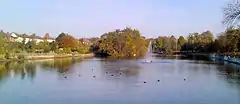 Raphael Park's lake pictured from Main Road, 2008 | |
  | |
| Type | Urban park |
| Location | Gidea Park, Romford, London, United Kingdom |
| Coordinates | 51.589°N 0.190°E |
The southern entrance to Raphael Park is on Main Road, formerly called Hare Street, and the northern entrance is just south of the A12 Eastern Avenue. The western boundary of the park follows the line of Black's Brook, a small stream that was dammed where the park meets Main Road to form a lake 12–20 ft deep and called Black's Canal, this being done before the park was created. The dam itself is just inside the park next to the 18th century bridge which carries Main Road and known as Black's Bridge.[1]
The park itself is part of the parkland that once surrounded Gidea Hall. Raphael Park contains two ancient Pedunculate Oaks recorded by the Woodland Trust.[2] The park is named after Sir Herbert Raphael MP, who gave it to Romford Urban District in 1904.[3]
In addition to the lake, which is used for angling, there are several amenities provided within the park. In the southern part of the park is a bandstand, and then near the end of the lake is a rockery which is used by the Romford Summer Theatre.[4] Beyond this point the park widens to the east, and there are sports pitches (football in winter and cricket in summer) and sunken tennis courts, the sunken nature of which is reputed to be the result of sand having been dug there for use in costruction of the surrounding houses.[5] To the north of the tennis courts is a children's play area which was remodelled in 2009, the curcular play area plus tennis courts having previously been filled with water and known as the "Spoon Pond".[6] Apart from these the park consists of parkland, mature woodland and grassland.
References
- Fryer, John (2004). Romford. A pocket album. Salisbury: Frith book company. pp. 38–43. ISBN 1 85937 888 9.
- The Woodland Trust | Recording | Tree details
- Mills, A., Dictionary of London Place Names, (2001), Oxford
- "Romford Summer Theatre home". ROMFORD SUMMER THEATRE. Retrieved 6 February 2016.
- Crossley, H J (2002). Grandfather's Romford (2nd ed.). Ian Henry publications Ltd. ISBN 0 86025 524 7.
- "Ordance Survey 6-inch map Essex LXVI (includes: Dagenham; Havering Atte Bower; Romford.)". National Library of Scotland. 1898. Latitude 51.591181, Longitude 0.189905. Retrieved 31 January 2021.