Rattlesnake Creek (Ohio)
Rattlesnake Creek is a tributary of Paint Creek,[1] 42.3 miles (68.1 km) long,[2] in south-central Ohio in the United States. Via Paint Creek and the Scioto and Ohio Rivers, it is part of the watershed of the Mississippi River, draining an area of 277 square miles (720 km2).[2] According to the Geographic Names Information System, it has also been known historically as "Rattlesnake Fork." [3]
Rattlesnake Creek rises near South Solon in southwestern Madison County, and flows generally southeastwardly through Fayette, Clinton and Highland counties, past the town of Octa. It joins Paint Creek in Paint Creek State Park as an arm of Paint Creek Lake,[4] 5 miles (8.0 km) south of Greenfield.[1]
Parts of the creek flow through rapids; 3 miles (4.8 km) in Highland County have been rated Class II (IV) whitewater rapids.[5]
A USGS stream gauge on the creek at Centerfield in Highland County recorded a mean annual discharge of 244.8 cubic feet per second (6.93 m3/s) during water years 1972-1981.[6]
Gallery
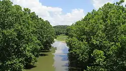 Rattlesnake Creek as viewed from Ohio State Route 138 in Highland County.
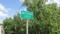 Rattlesnake Creek sign
See also
References
- Columbia Gazetteer of North America entry for Paint Creek
- Ohio Department of Natural Resources. A Guide to Ohio Streams. Chapter 10: Major Ohio Watersheds (pdf)
- U.S. Geological Survey Geographic Names Information System: Rattlesnake Creek
- Ohio whitewater - Rattlesnake Creek, Highland County, Riverfacts.com. Accessed 2007-10-13.
- "USGS Surface Water data for Ohio: USGS 03232300 Rattlesnake Creek at Centerfield OH". waterdata.usgs.gov. Archived from the original on 2020-08-20. Retrieved 2020-08-20.