Rattlesnake Fire (2018)
The Rattlesnake Fire was a wildfire that started on the Fort Apache Indian Reservation on April 11, 2018 and expanded into the San Carlos Indian Reservation and Apache-Sitgreaves National Forests in Arizona in the United States. The fire burned a total of 26,072 acres (106 km2). The cause of the fire remains unknown.
| Rattlesnake Fire | |
|---|---|
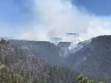 The Rattlesnake Fire on April 13, 2018 | |
| Location | Fort Apache Indian Reservation, San Carlos Indian Reservation, and Apache-Sitgreaves National Forests, Arizona, United States |
| Coordinates | 33.656°N 109.506°W |
| Statistics[1] | |
| Date(s) | April 11, 2018 – |
| Burned area | 26,072 acres (106 km2) |
| Cause | Unknown |
| Map | |
 Location of fire in Arizona. | |
Events
April
The Rattlesnake fire was reported around 1:30 p.m. on April 11, 2018, on the Fort Apache Indian Reservation, approximately 20 miles southeast of Whiteriver, Arizona, in a remote area east of Rattlesnake Point.[2] By the next day, the fire had grown to 400 acres (2 km2) and had expanded to the Apache-Sitgreaves National Forest. The cause of the fire was unknown.[3] On June 3, the fire expanded into the San Carlos Indian Reservation and 158 fire personnel were recruited to fight the fire.[4]
The Rattlesnake Fire had grown to 2,644 acres (11 km2) by April 14, with red flag warnings in effect. It also expanded into the Bear Wallow Wilderness. Air support was utilized for the first time and closures were put in place for areas of the national forest, along with several roads.[5] The next day, the fire was at three percent containment and officials reported that while the cause of the fire was still unknown, it was believed to be cause by a human.[6]
By April 18, the fire had ballooned to 11,339 acres (46 km2), with the fire growing in the south and southeast, particularly on the San Carlos Indian Reservation and Bear Wallow Wilderness.[7] It grew even more by April 25, expanding to 21,513 acres (87 km2) due to warming trends, including hot days, little humidity and light winds. Fire fighters focused on containing spot fires and continuing burnout efforts by removing ground fuels.[8]
The fire was declared 63 percent contained at 25,996 acres (105 km2) on April 29.[9]
May
By May 1, the fire had burned 26,072 acres (106 km2) and remained 63 percent contained. Red flag conditions persisted along with low humidity. Forest Road 25 was closed.[10] Cooler weather and light precipitation enabled crews to make headway on containment, with the fire being at 82 percent containment by the evening of May 2.[11]
References
- "Rattlesnake Fire". InciWeb. US Forest Service. Retrieved 5 June 2018.
- "RATTLESNAKE FIRE ON THE FORT APACHE INDIAN RESERVATION - InciWeb the Incident Information System". InciWeb. United States Forest Service. Retrieved 6 June 2018.
- "Rattlesnake Fire Update - InciWeb the Incident Information System". InciWeb. United States Forest Service. Retrieved 6 June 2018.
- "Rattlesnake Fire Update - InciWeb the Incident Information System". InciWeb. United States Forest Service. Retrieved 6 June 2018.
- "Rattlesnake Fire Update - InciWeb the Incident Information System". InciWeb. United States Forest Service. Retrieved 6 June 2018.
- "Rattlesnake Fire - Sunday Update 4:00 pm - InciWeb the Incident Information System". InciWeb. United States Forest Service. Retrieved 6 June 2018.
- "Rattlesnake Fire Update, Wednesday, April 18, 2018 - InciWeb the Incident Information System". InciWeb. United States Forest Service. Retrieved 6 June 2018.
- "Burnout Activities Turn the Corner at Highway 191 - InciWeb the Incident Information System". InciWeb. United States Forest Service. Retrieved 6 June 2018.
- "Rattlesnake Fire Daily Update 4-29-2018 - InciWeb the Incident Information System". InciWeb. United States Forest Service. Retrieved 6 June 2018.
- "Rattlesnake Fire Update, Tuesday, May 1, 2018 - InciWeb the Incident Information System". InciWeb. United States Forest Service. Retrieved 6 June 2018.
- "Rattlesnake Fire Update, Wednesday, May 2, 2018 - InciWeb the Incident Information System". InciWeb. United States Forest Service. Retrieved 6 June 2018.
![]() This article incorporates public domain material from websites or documents of the United States Department of Agriculture.
This article incorporates public domain material from websites or documents of the United States Department of Agriculture.
External links
 Media related to Rattlesnake Fire at Wikimedia Commons