Raung
Raung (Indonesian: Gunung Raung) is one of the most active volcanoes on the island of Java in Indonesia.
| Raung | |
|---|---|
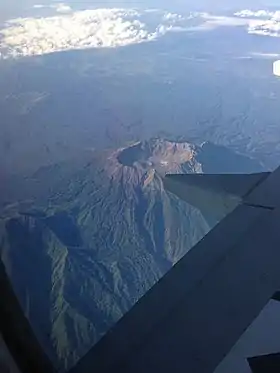 View Captured in the Sky By Plane, 2013 | |
| Highest point | |
| Elevation | 3,332 m (10,932 ft) [1] |
| Prominence | 3,069 m (10,069 ft) [2][3] Ranked 83rd |
| Isolation | 124 km (77 mi) |
| Listing | Ultra Ribu |
| Coordinates | 8°07′30″S 114°02′30″E [1] |
| Geography | |
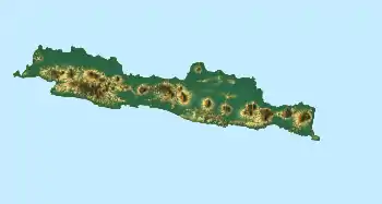 Raung Location on Java, Indonesia | |
| Location | Banyuwangi, East Java, Indonesia |
| Geology | |
| Mountain type | Stratovolcano |
| Last eruption | 2021 |
| Climbing | |
| Easiest route | Sumberwaringin |
| Normal route | Kalibaru, Glenmore |
It is located in the province of East Java and has a 2-kilometer-wide (1.2 mi) and 500-meter-deep (1,600 ft) caldera surrounded by a grayish rim. The difference in color of the rim and the flanks of the volcanoes is caused by the rim’s lack of vegetation compared with the healthy and extensive vegetation on the flanks. Raung, standing almost 3,332 metres (10,932 ft) above sea level, is the tallest volcano of this cluster. Although the valleys between the major volcanoes boast fertile, ash-enriched soil for agriculture, available land is very limited. Raung[4] contains centres constructed along a NE to SW line, with Gunung Suket and Gunung Gadung stratovolcanoes being located to the northeast and west, respectively. Mount Raung can be seen from Lovina Beach, Singaraja, North Bali. The normal route climbing is through Bondowoso and Sumber Wringin.[5]
Its earliest recorded eruption was in 1586 which resulted in fatalities; between 1586 and 1817 five more deadly eruptions were recorded.[6]
2015 Eruption
_from_Bali_strait_at_dawn.jpg.webp)
The volcano started to display increased activity on 24 June 2015, and on 29 June 2015 began to eject material causing a dust cloud that resulted in warnings being issued to residents within 3 kilometers (1.9 mi) radius of the caldera, and causing disruption to flights in and out of nearby Bali.[7] According to Landsat images in early July 2015, there is a new lava pool on the mountain, giving the volcano two lava pools, including an older pool. This will likely delay the full eruption of the volcano for a short while. Currently the caldera is still sufficient to keep the lava inside.[8]
From July 9, 2015, several airports throughout Indonesia—including on the popular holiday island of Bali and in Surabaya during Idul Fitri—were closed due to the ash being produced by the eruptions.[9] The explosive ash emissions stopped during the afternoon of 14 August. It appears likely that the eruption has more or less come to an end.
Gallery
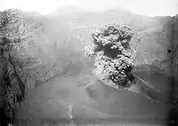 Eruption of 1913
 Eruption of 1927
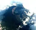 Raung, September 2005
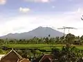 Mount Raung seen from Kalibaru Town, 2013
See also
- List of volcanoes in Indonesia
- List of Ultras of Malay Archipelago
References
- "Raung". Global Volcanism Program. Smithsonian Institution. Retrieved 2017-12-24.
- "Mountains of the Indonesian Archipelago" Peaklist.org. Retrieved 2011-11-22.
- "Gunung Raung, Indonesia" Peakbagger.com. Retrieved 2011-11-22.
- "Perjalanan Extreme Mendaki Gunung Raung". Retrieved January 20, 2020.
- "Gunung Raung". Retrieved March 8, 2013.
- McClelland, Lindsay (1989). Global Volcanism, 1975-1985. Englewood Cliffs, N.J: Prentice Hall. ISBN 0-13-357203-X.
- "Status Siaga Gunung Raung dan Cerita tentang Mangkuk Raksasa" (in Indonesian). Detik News. 29 June 2015. Retrieved 22 July 2015.
- "Muncul Lubang Magma Baru di Kaldera Raung". July 4, 2015.
- "CNN:Airports Close Due to Raung Ash Cloud". July 10, 2015.
External links
![]() Media related to Mount Raung at Wikimedia Commons
Media related to Mount Raung at Wikimedia Commons