Rhode Island Route 116
Route 116 is a state highway running 25.1 miles (40.4 km) in Providence County, Rhode Island. Its southern terminus is at Route 33 and Route 117 in Coventry, and its northern terminus is at Route 114 in Cumberland.
| ||||
|---|---|---|---|---|
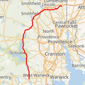
Route 116 highlighted in red | ||||
| Route information | ||||
| Maintained by RIDOT | ||||
| Length | 25.1 mi[1] (40.4 km) | |||
| Major junctions | ||||
| South end | ||||
| North end | ||||
| Location | ||||
| Counties | Providence | |||
| Highway system | ||||
Rhode Island Routes
| ||||

Route description
Route 116 begins at an intersection with RI-33 and RI-117 in Coventry, Rhode Island. It is known as Knotty Oak Road. Route 116 runs north for 2.7 miles (4.3 km) from Route 117 to the Scituate town line. In Scituate, the route runs 9.5 miles (15.3 km). The highway intersects the following routes from south to north: Route 115, Route 12, Route 14, and US 6. In Glocester, the route runs 0.6 miles (0.97 km). It reaches US 44 in Smithfield. It runs concurrent with US 44 for half a mile. Then, it turns northeast. It continues as Pleasant View Avenue as it then meets Route 104. It runs concurrently north with Route 104, then turns east as the George Washington Highway. The George Washington Highway is a rural, two-laned expressway with a 50 mph speed limit. The road continues east and ends at Route 114 in Cumberland.
Major intersections
The entire route is in Providence County.
| Location | mi[1] | km | Destinations | Notes | |
|---|---|---|---|---|---|
| Coventry | 0.0 | 0.0 | Southern terminus | ||
| Hope | 2.9 | 4.7 | Western terminus of Route 115 | ||
| Scituate | 4.9 | 7.9 | |||
| 6.9 | 11.1 | ||||
| North Scituate | 10.7 | 17.2 | |||
| Greenville | 14.0 | 22.5 | Southern terminus of concurrency with US 44 | ||
| 14.1 | 22.7 | Northern terminus of concurrency with US 44 | |||
| 15.0 | 24.1 | Southern terminus of concurrency with Route 5 | |||
| Smithfield | 16.8 | 27.0 | Southern terminus of concurrency with Route 104 | ||
| 17.0 | 27.4 | Northern terminus of concurrency with Routes 5 and 104 | |||
| 18.3 | 29.5 | ||||
| Lincoln | 21.4 | 34.4 | Interchange | ||
| 22.2 | 35.7 | ||||
| Blackstone River | 23.1 | 37.2 | Bridge | ||
| Cumberland | 23.3 | 37.5 | Southern terminus of concurrency with Route 122 | ||
| 23.4 | 37.7 | Southern terminus of concurrency with Route 122 | |||
| 25.1 | 40.4 | Northern terminus | |||
1.000 mi = 1.609 km; 1.000 km = 0.621 mi
| |||||
Notes
Route 116 is a major corridor in Lincoln, Cumberland and parts of Smithfield.
The interchange between Route 116 and Route 146 was the first cloverleaf interchange to be constructed in the state. In the mid-2000s the ramps in the interchange's southeast quadrant were removed, being replaced by rebuilt ramps in the northeast quadrant which join 116 at a new signaled intersection with turn lanes.
References
- Google (December 30, 2013). "Route 116" (Map). Google Maps. Google. Retrieved December 30, 2013.