Rhode Island Route 136
Route 136 is a 7.4-mile-long (11.9 km) numbered state highway in the U.S. state of Rhode Island. Its southern terminus is at Route 114 in Bristol, and its northern terminus is at the Massachusetts border where it continues as Massachusetts Route 136.
| ||||
|---|---|---|---|---|
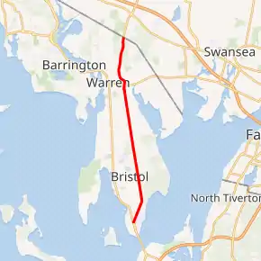
Route 136 highlighted in red | ||||
| Route information | ||||
| Maintained by RIDOT | ||||
| Length | 7.4 mi[1] (11.9 km) | |||
| Major junctions | ||||
| South end | ||||
| North end | ||||
| Location | ||||
| Counties | Bristol | |||
| Highway system | ||||
Rhode Island Routes
| ||||

Route description
Route 136 takes the following route through the State:
Major intersections
The entire route is in Bristol County.
| Location | mi[1] | km | Destinations | Notes | |
|---|---|---|---|---|---|
| Bristol | 0.0 | 0.0 | Southern terminus | ||
| Warren | 5.6 | 9.0 | |||
| 7.6 | 12.2 | Continuation into Massachusetts | |||
| 1.000 mi = 1.609 km; 1.000 km = 0.621 mi | |||||
References
- Google (December 30, 2013). "Route 136" (Map). Google Maps. Google. Retrieved December 30, 2013.
External links
This article is issued from Wikipedia. The text is licensed under Creative Commons - Attribution - Sharealike. Additional terms may apply for the media files.