River Bride, Dorset
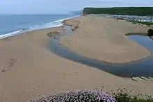
The River Bride is a river in Dorset, England, situated between the towns of Dorchester and Bridport. It is approximately 6.5 miles (10.5 km) long and has a catchment area of 15 square miles (39 km2).[1] It rises at an altitude of 90 metres (300 ft)[2] beneath an artificial lake at Bridehead House, Littlebredy, then flows west to its mouth on the English Channel near Burton Bradstock. Its name derives from the Celtic for boiling or gushing. It has nine tributaries and descends more than 60 metres (200 ft) in its first three miles.[1] It reaches the coast just west of Burton Bradstock through a break in coastal cliffs at Burton Freshwater; here it meets the western end of Chesil Beach where it "forms itself into a pool and fights to get to the sea intact before sinking into the shingle."[3]
| River Bride | |
|---|---|
 Source of the River Bride at Bridehead House, Littlebredy | |
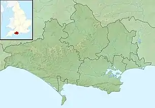 Location within Dorset | |
| Etymology | Celtic |
| Location | |
| Country | England |
| County | Dorset |
| District | Dorset |
| Towns and villages | Littlebredy, Burton Bradstock |
| Physical characteristics | |
| Source | |
| • location | Littlebredy, Dorset, England |
| • elevation | 300 ft (91 m) |
| Mouth | |
• location | Burton Bradstock, Dorset, England |
• coordinates | 50.7026°N 2.7405°W |
| Discharge | |
| • location | Burton Bradstock |
Notes
- C. J. Bailey (1982). "Extracts from C.J. Bailey's Book "The Bride Valley"". www.burtonbradstock.org.uk. Retrieved 6 March 2014.
- Ordnance Survey 1:25,000 Pathfinder Series of Great Britain, Sheet SY 49/59 Bridport, published 1977
- Roland Gant (1980). Dorset Villages. Robert Hale Ltd. p. 152. ISBN 0 7091 8135 3.