River Foss Barrier
The River Foss Barrier is a floodgate that straddles the River Foss in York, England at the confluence of the Rivers Ouse and Foss just south of Clifford's Tower. The barrier was opened in 1988 after flooding from the Foss and two other becks caused more damage to properties in the city than when the Ouse was in spate. The purpose of the barrier is to prevent backing up of floodwater from the Foss when it meets the surgewater of the Ouse and cannot drain away.[1] The pumps adjacent to the barrier move water from the Foss into the Ouse.[2]

History
After many years of flash flooding, the York Water Authority commissioned the River Foss Barrier. Work on the barrier commenced in October 1986 and the barrier was opened in November 1988.[3] The main aim of the defence is to prevent back wash from the River Ouse into the River Foss causing flooding upstream of the River Foss.[4]
A probability analysis was carried out for flows in the River Foss combined with high levels in the River Ouse. This indicated a maximum flow of 30 tonnes (30 long tons; 33 short tons) of water per second. In March 2016, a budget was approved to increase capacity to 40 tonnes (39 long tons; 44 short tons) per second.[5]
The barrier weighs 16.5 tonnes (16.2 long tons; 18.2 short tons) and is operated as a turnover lift gate. When in an open state, it is held horizontally above the river and boats and barges pass underneath whilst regular and efficient maintenance can be performed.[6]
The normal water level at York is established as 5 metres (16 ft) Above Ordnance Datum (AOD)[7] and the duty officer is alerted when the River Ouse reaches 7.4 metres (24 ft) AOD. After 7.8 metres (26 ft) AOD is reached, the barrier is lowered into the Foss. Boats are alerted by way of visible and audible alarms and after the alarm is sounded, the pumps are activated, the silt from the bed is cleared and the barrier can drop into a tight fit.[6]
The electrically driven barrier takes 4 minutes to lower into position. Eight pumps transfer 30 tonnes (30 long tons; 33 short tons) of water per second from River Foss into River Ouse through the side culvert. These pumps maintain the water level of the Foss at around 6.5 metres (21 ft) AOD. When the flood subsides and the level of the Ouse drops to 6.5 metres (21 ft), the levels of before and after barrier are equalised.
Warning alarms sound to alert everyone before the gate is opened and the pumps shut down.
Site information
|
Link to current levels:[8]
links to Shoothill GaugeMap |
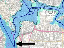
Possible flooding around the barrier[9]
 |
|---|
Side view
 side view without retaining wall |
Top view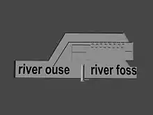 Top view of Foss river barrier |
|---|---|
With barrier up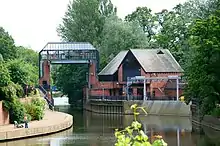 Foss River barrier in open position |
With barrier down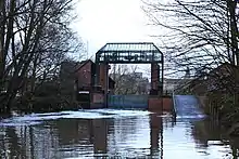 Foss River Barrier in closed position |
Boxing day flooding – 26 December 2015
On 26 December 2015, too much water entered the River Foss causing a possible overspill and damage to the electrical services of the barrier. A telephone conference with senior county bodies was convened and it was decided to open the barrier to prevent overflooding. At this time, the level was 20 centimetres (7.9 in) below the flood level (10.2 metres (33 ft)) on 4 November 2000.[10]
It was decided that it would be better to have barrier open, rather than stuck shut by the waterlogging of the electrical services.[2] This decision resulted in a few hundred houses in York city centre being flooded but spared another few hundred houses upstream.
A report published on 12 May 2016 states that water entered the pump room and would have damaged electrics. Without electrics, the motors turning the barrier would not have been operational.[11] Flooding of more properties was inevitable. According to the Environment Agency, by lifting the barrier, before the power cut off, the flood damage would be restricted to fewer properties.[12]
Improvements
In March 2016, extra funds were allocated to upgrade the pumps to 40 tonnes of water per second (from 30 tonnes per second) and moving the electrics to safer point.[13]
Media reports stated that the Environment agency had taken recommendations onboard and had committed to addressing them.[14] Extra modern software to monitor river levels was also bought.
Reports have been published that reveal new pumps are to be installed by September 2016.[13][15] This work was completed in November 2016.[16] Further work was planned to install a new power supply and raise the pumping station’s operation room onto a new, higher level.[16]
100 staff and contractors will work 20 months to complete the upgrade to the barrier. The new pumps weigh 6.5 tonnes each and cost £800,000. Approximately 50 cubic metres, or 50 tonnes, of water per second can be pumped.[16]
This improvement cost £17 million and is part of a wider improvement scheme.[17]
The existing barrier will continue to operate until all improvements have been completed.[18]
Flood defence scheme
The River Foss Barrier is part of a wider scheme that includes weirs, dams, temporary storage schemes, walls, barriers and temporary water wall that all contribute to reducing, diverting, holding back and preventing domestic overspill in the event of an extraordinary weather event.[19]
References
- "Reducing the risk of flooding" (pdf). Environment Agency. February 2009. p. 10. Retrieved 22 March 2016.
- "The Foss Barrier: reducing the risk of flooding". Gov.uk. 26 January 2016. Retrieved 22 March 2016.
- Dooks, Brian (28 December 2005). "Flood barrier to be checked on-line". Yorkshire Post. Retrieved 22 March 2016.
- "River Foss Flood Alleviation Scheme" (pdf). Environment Agency (NRA). Information Services Unit. p. 7. Retrieved 22 March 2016.
- Laycock, Mike (11 March 2016). "Foss Barrier upgrade: all eight pumps will be replaced – new pumps taking 40 tonnes per second". York Press. Retrieved 22 March 2016.
- "Reducing the risk of flooding" (pdf). Environment Agency. February 2009. p. 12. Retrieved 22 March 2016.
- "reducing the risk of flooding" (pdf). Environment Agency. February 2009. p. 4. Retrieved 22 March 2016.
- "GaugeMap – Latest River, Flow and Groundwater Levels Map for Britain & Ireland".
- Agency, Environment. "What's in your backyard?". maps.environment-agency.gov.uk.
- "BBC – funding for Foss barrier". BBC News. Retrieved 15 March 2015.
- "Foss Barrier: investigation report – Publications – GOV.UK". www.gov.uk. Retrieved 13 May 2016.
- "Floods unleash unprecedented criticism" David Shukman, Science editor, 30 December 2015, at bbc.co.uk Accessed 17 July 2017
- "New pumps confirmed for York's Foss flood barrier". BBC News. Retrieved 21 March 2016.
- "Utility Week – EA to address report recommendations in Foss Barrier upgrade". utilityweek.co.uk. Retrieved 18 May 2016.
- "York's Foss flood barrier: New pump to be installed". BBC News. 26 September 2016. Retrieved 26 December 2016.
- "Installation of eight new pumps at Foss Barrier in York is complete". ITV News. Retrieved 26 December 2016.
- "New pumps installed at Foss Barrier". York Press. Retrieved 26 December 2016.
- "£13m flood prevention scheme launched in devastated city". The Northern Echo. Retrieved 20 October 2020.
- "Environment Agency reaches milestone in £17m Foss Barrier flood defence scheme". Water Briefing. 15 November 2016. Retrieved 20 October 2020.