River Parrett Trail
The River Parrett Trail is a long-distance footpath that can be used for walking, jogging, or running, following the route of the River Parrett in Somerset, England. The trail, which is 50 miles (80 km) long,[1][2] runs from Chedington in Dorset to the mouth of the river in Bridgwater Bay where it joins the West Somerset Coast Path.
| River Parrett Trail | |
|---|---|
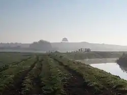
 View toward Burrow Hill from the River Parrett Trail on a misty morning | |
| Length | 47 mi (76 km) |
| Location | Dorset & Somerset |
| Trailheads | Chedington/Bridgwater Bay |
| Use | Hiking |
It passes many landmarks and places of interest including; Burrow Hill Cider Farm, Muchelney Abbey, West Sedgemoor (a Site of Special Scientific Interest (SSSI), the Blake Museum, Westonzoyland Pumping Station Museum, the site of the Battle of Sedgemoor and finally discharging into Bridgwater Bay (another SSSI).
The trail is managed by The Parrett Trail Partnership, a consortium of agencies including:[3] Arts Council England, South West, British Waterways, Cannington Agricultural College, Country Land and Business Association, Natural England, Environment Agency, National Farmers Union, Royal Society for the Protection of Birds, Sedgemoor District Council, Somerset County Council, Somerset Wildlife Trust, South Somerset District Council, South West Tourism, Take Art!, Somerset West and Taunton District Council and Dorset Council.
Route and points of interest
The following table lists key points of interest along the river.
| Point | Coordinates (Links to map resources) |
OS Grid Ref | Notes |
|---|---|---|---|
| Source | 50.847°N 2.733°W | ST484055 | near Chedington |
| A303 bridge | 50.947°N 2.783°W | ST450167 | South Petherton |
| River Isle confluence | 51.009°N 2.832°W | ST416237 | |
| River Yeo confluence | 51.032°N 2.822°WRiver Yeo confluence) | ST424262 | |
| Bow Bridge | 51.036°N 2.835°W | ST415266 | Langport |
| Monk's Leaze Clyce | 51.048°N 2.844°W | ST408280 | Regulates flow into Sowy River |
| River Tone confluence | 51.067°N 2.917°W | ST357302 | Located at Burrowbridge |
| Westonzoyland Pumping Station Museum | 51.091°N 2.944°W | ST339328 | |
| Town Bridge | 51.129°N 3.001°W | ST300372 | Bridgwater |
| Drove Bridge | 51.138°N 3.001°W | ST300382 | Most seaward and newest road bridge on river[4] |
| Dunball Wharf | 51.162°N 2.989°W | ST309408 | |
| Mouth | 51.229°N 3.009°W | ST296482 |
 Trail marker on the River Parrett Trail
 Family of mute swans nesting by the River Parrett Trail near Langport
 Westonzoyland Pumping Station, viewed from the River Parrett Trail
 View of the Somerset Levels from the River Parrett Trail
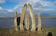
 Seat, made in 1996, on the west bank of the Parrett Estuary, a mile from the village of Combwich
References
- "River Parrett Trail". Long distance walkers association. Retrieved 3 July 2010.
- "The River Parrettt Trail" (PDF). South Somerset Council. Retrieved 20 April 2018.
- "The Parrett Trail Partnership". The Parret Trail Partnership. Retrieved 29 August 2008.
- Statutory Instrument 1995 No. 270, NDR confirmation order
External links
- Official River Parrett Trail website
- River Parrett Trail at the Long Distance Walkers Association
- The River Parrett Trail (re)visited - website encouraging arts related to the trail