River Pinn
The River Pinn is in the historic county of Middlesex, in the western part of Greater London. Its source is in Harrow Weald and its confluence with Frays River makes it a tributary of the River Colne.
| River Pinn | |
|---|---|
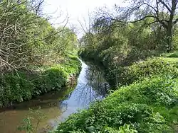 River Pinn at Ickenham | |
| Location | |
| Country | England |
| Region | Greater London |
| Physical characteristics | |
| Source | |
| • location | 51°37'12.5"N 0°20'54.1"W |
| • elevation | Roughly 120m |
| Mouth | |
• location | 51°30'52.1"N 0°28'48.0"W |
• elevation | 31m |
| Basin features | |
| Progression | River Colne |
Route
The river runs through Pinner, Eastcote and Ruislip: the latter may be a notable rise-lip of land as 17th century maps often have the place name but likely derives from "rush leap" - from the local width of the river.[1] It then runs through Ickenham and on to Uxbridge, where it passes through the former grounds of RAF Uxbridge and Brunel University. The Pinn continues on to Pield Heath and Cowley, passing under the Grand Union canal before joining the Frays River, an anabranch of the Colne, at Yiewsley.[2]
During the Second World War, the river was temporarily dammed near Pinner High Street for use as a water supply for putting out fires from air raids.[1]
Celandine Route
Celandine Route is a 12-mile walk through an area of woodland, meadows and parks. It finishes where the River Pinn meets the Grand Union Canal. A short walk down the "Slough arm" of the Grand Union Canal brings one to Fray's River.
See also
References
- "River Pinn". London Borough of Hillingdon. 26 June 2007. Retrieved 14 March 2011.
- "Cowley: Introduction", A History of the County of Middlesex: Volume 3: Shepperton, Staines, Stanwell, Sunbury, Teddington, Heston and Isleworth, Twickenham, Cowley, Cranford, West Drayton, Greenford, Hanwell, Harefield and Harlington (1962), pp. 170-172. Insititute of Historical Reaearch, University of London. Retrieved 27 October 2008.