River Sherford
The River Sherford, also frequently called the Sherford River, is one of the four main rivers flowing into Poole Harbour in the county of Dorset, England. It is about 12 kilometres long[2] and drains over the tertiary beds near the harbour.[3]
| River Sherford | |
|---|---|
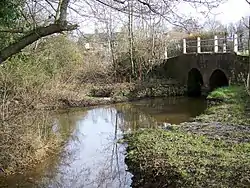 Organford Bridge on the Sherford | |
| Physical characteristics | |
| Source | |
| • location | Whitefield near Bere Regis |
| Mouth | |
• location | Lytchett Bay, Poole Harbour |
• coordinates | 50°43′34″N 2°03′00″W |
| Length | 12.317 km (7.653 mi)[1] |
| Basin size | 45.348 km2 (17.509 sq mi)[1] |
Course
It rises at a spring in the hamlet of Whitefield, west of Lytchett Matravers, flows southwards into Morden Park lake and then eastwards, passing under the A351 before discharging into Lytchett Bay as the Rock Lea River on the northern side of Poole Harbour.[4]
Water quality
The Sherford's water body status in 2013 was graded "poor" by the Environment Agency.[5]
References
- Sherford River at environment.data.gov.uk. Retrieved 6 Nov 2016.
- Poole Harbour Lake Beach at beachquality.uk. Retrieved 6 Nov 2016.
- Poole Harbour Catchment Information at www.wessexwater.co.uk. Retrieved 6 Nov 2016.
- OS topographic map, 1:25,000 series, No. OL15 Purbeck & South Dorset.
- Wessex Water, Poole Harbour Catchment Initiative: Catchment Plan: Update - May 2014. Appendix 2.
This article is issued from Wikipedia. The text is licensed under Creative Commons - Attribution - Sharealike. Additional terms may apply for the media files.