Rockcastle River
The Rockcastle River is a 54.8-mile-long (88.2 km)[2] river primarily in Rockcastle County, Kentucky, United States. It is a tributary of the Cumberland River and therefore, via the Ohio River, part of the Mississippi River watershed. In 1750 it was discovered and named the Lawless River by Dr. Thomas Walker and his exploring party. It was soon renamed by hunter Isaac Lindsey for its castle-like rock formations. It is about 60 to 80 feet (18 to 24 m) wide throughout its length. The river has an important native walleye population that has stabilized in recent years. A trip down the lower Rockcastle is one of the most remote trips into the Appalachian wilderness you can have without hiking the Appalachian Trail.
| Rockcastle River | |
|---|---|
 A kayak on the Rockcastle River | |
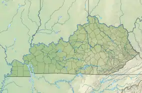 Location of the mouth of the Rockcastle River in Kentucky | |
| Location | |
| Country | United States |
| State | Kentucky |
| Physical characteristics | |
| Source | Jackson County line |
| • location | Idaho |
| • coordinates | 37°20′10″N 84°7′8″W[1] |
| Mouth | Cumberland River |
• location | Idaho |
• coordinates | 36°57′36″N 84°21′25″W[1] |
• elevation | 722 ft (220 m)[1] |
| Length | 55 mi (89 km) |
| Basin size | 4,100 sq mi (11,000 km2) |
The river has two forks, the Middle Fork, which forms in southern Jackson County, and the South Fork, which forms in Clay County. They meet at the Jackson County line and flow south, forming the southeast border of Rockcastle County. It makes up the border between Pulaski and Laurel counties before flowing into the Cumberland River.
See also
References
- U.S. Geological Survey Geographic Names Information System: Rockcastle River
- U.S. Geological Survey. National Hydrography Dataset high-resolution flowline data. The National Map, accessed June 8, 2011