Rothley Brook
The Rothley Brook is a left bank tributary of the River Soar in Leicestershire, England.
| Rothley Brook | |
|---|---|
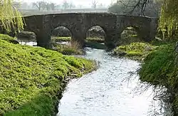 Packhorse Bridge Anstey | |
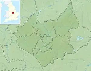 Confluence with Soar shown in Leicestershire | |
| Location | |
| Country | England |
| Counties | Leicestershire |
| Physical characteristics | |
| Source | Stanton-under-Bardon |
| • location | 52.688402°N 1.309083°W |
| • elevation | 174 m (571 ft) |
| Mouth | Rothley |
• coordinates | 52°42′5″N 1°7′26″W |
| Length | 29 km (18 mi) |
| Basin size | 96 km2 (37 sq mi) |
| Discharge | |
| • location | Rothley |
| • average | 0.73 m3/s (26 cu ft/s) |
| Progression : Rothley - Soar - Trent - Humber | |
Course
It first becomes noticeable after Thornton Reservoir, near the village of Thornton in the National Forest. It then flows through Desford and Ratby before being joined by a tributary from Kirby Muxloe just before Glenfield.
After Glenfield, it flows around Anstey, Cropston and Thurcaston before finally reaching Rothley where it joins the River Soar.
History
It was previously known as "Heathe Brook".[1]
Castle Hill Park
The Rothley Brook is one of the defining features of the large Castle Hill Country Park in Anstey and runs parallel to Cropston Road and the A46 as well as passing underneath Anstey Lane, Thurcaston. The parts of the brook which flow through Castle Hill Park are a haven for wildlife, including kingfishers.