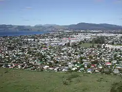
Rotorua
Rotorua [ˌɾɔtɔˈɾʉa][4][5] (Māori: Te Rotorua-nui-a-Kahumatamomoe "The second great lake of Kahumatamomoe") is a city on the southern shores of Lake Rotorua from which the city takes its name, located in the Bay of Plenty Region of New Zealand's North Island. It is the seat of the Rotorua Lakes District, a territorial authority encompassing Rotorua and several other nearby towns. The majority of the Rotorua District is in the Bay of Plenty Region, but a sizeable southern section and a small western section are in the Waikato region.[6] Rotorua is in the heart of the North Island, 60 kilometres (37 miles) south of Tauranga, 80 km (50 mi) north of Taupō, 105 km (65 mi) east of Hamilton, and 230 km (140 mi) southeast of the nation's most populous city, Auckland.
Rotorua
| |
|---|---|
 | |
| Nickname(s): | |
 Rotorua | |
| Coordinates: 38°08′16″S 176°15′05″E | |
| Country | |
| Region | Bay of Plenty |
| Territorial authority | Rotorua Lakes Council |
| Settled by Māori | c. 1350 |
| Founded | 1883 |
| Borough status | 1922 |
| City status | 1962 |
| City status revoked | 1989 |
| Electorate | Rotorua |
| Government | |
| • Mayor | Steve Chadwick |
| Area | |
| • Territorial | 2,614.9 km2 (1,009.6 sq mi) |
| • Urban | 48.04 km2 (18.55 sq mi) |
| • Metro | 89.28 km2 (34.47 sq mi) |
| Elevation | 280 m (920 ft) |
| Population (June 2020)[3] | |
| • Territorial | 77,300 |
| • Density | 30/km2 (77/sq mi) |
| • Urban | 58,500 |
| • Urban density | 1,200/km2 (3,200/sq mi) |
| • Metro | 58,500 |
| • Metro density | 660/km2 (1,700/sq mi) |
| Time zone | UTC+12 (NZST) |
| • Summer (DST) | UTC+13 (NZDT) |
| Postcode(s) | 3010, 3015 |
| Area code(s) | 07 |
| Local iwi | Ngāti Whakaue, Te Arawa |
| Website | www |
Rotorua has an estimated permanent population of 58,500, making it the country's 12th largest urban area, and the Bay of Plenty's second largest urban area behind Tauranga. The Rotorua District has a total estimated population of 77,300[3], of which 3,600 live in the Waikato section.[6]
Rotorua is a major destination for both domestic and international tourists; the tourism industry is by far the largest industry in the district. It is known for its geothermal activity, and features geysers – notably the Pohutu Geyser at Whakarewarewa – and hot mud pools. This thermal activity is sourced to the Rotorua caldera, in which the town lies. Rotorua is home to the Toi Ohomai Institute of Technology.
The Lakes of Rotorua are a collection of many lakes surrounding Rotorua.
History
The name Rotorua comes from Māori, the full name for the city and lake is Te Rotorua-nui-a-Kahumatamomoe. Roto means 'lake' and rua means 'two' or in this case 'second' – Rotorua thus meaning 'Second lake'. Kahumatamomoe was the uncle of the Māori chief Ihenga, the ancestral explorer of the Te Arawa.[7] It was the second major lake the chief discovered, and he dedicated it to his uncle. It is the largest of a multitude of lakes found to the northeast, all connected with the Rotorua Caldera and nearby Mount Tarawera. The name can also mean the equally appropriate 'Crater lake'.[7]
The area was initially settled by Māori of the Te Arawa Iwi in the 14th century. During the early 1820s Ngapuhi led by chief Hongi Hika launched a series of raids into the Bay of Plenty as a part of the Musket Wars, in 1823 a Ngapuhi raiding party led by Hongi Hika attacked Te Arawa at their Pa (Fortified settlement) on Mokoia Island defeating them. The first European in the area was probably Phillip Tapsell who was trading from the Bay of Plenty coast at Maketu from 1828. He later married into Te Arawa and became highly regarded by them.[8] Missionaries Henry Williams and Thomas Chapman visited in 1831[7] and Chapman and his wife established a mission at Te Koutu in 1835.[9] This was abandoned within a year but Chapman returned in 1838 and established a second mission at Mokoia Island.[7][9]
The lakeshore was a prominent site of skirmishes during the New Zealand Wars of the 1860s. A "special town district" was created in 1883, to promote Rotorua's potential as a spa destination. The town was connected to Auckland with the opening of the Rotorua Branch railway and commencement of the Rotorua Express train in 1894, resulting in the rapid growth of the town and tourism from this time forward. Rotorua was established as a borough in 1922, elected its first mayor in 1923, and declared a city in 1962 before becoming a district in 1979.[10]
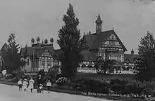 Pictured as a bath house in the early 20th century |
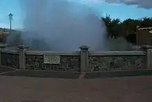 Hot springs present in much of Rotorua |
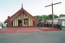 Māori meeting house in Rotorua, January 2001 |
Geography
Climate
The Rotorua region enjoys a mild temperate climate. Rotorua is situated inland from the coast and is sheltered by high country to the south and east of the city, resulting in less wind than many other places in New Zealand. During the winter months June – August temperatures can drop below 0 °C. Frost is common in Rotorua during its winter months, with an average of 57 ground frosts annually, and 20 nights per year below 0 °C. Snowfall in Rotorua is rare and since the 1970s has only been recorded twice. On 15 August 2011 and 13 July 2017 snowflakes fell in the town centre, and during the July 2017 snowfall, snow accumulated in the nearby Mamaku ranges and in the outer reaches of the district, where snowfall occurs on average once every three years.
| Climate data for Rotorua (1981–2010) | |||||||||||||
|---|---|---|---|---|---|---|---|---|---|---|---|---|---|
| Month | Jan | Feb | Mar | Apr | May | Jun | Jul | Aug | Sep | Oct | Nov | Dec | Year |
| Average high °C (°F) | 22.8 (73.0) |
22.9 (73.2) |
20.9 (69.6) |
18.0 (64.4) |
15.1 (59.2) |
12.6 (54.7) |
12.0 (53.6) |
12.8 (55.0) |
14.6 (58.3) |
16.4 (61.5) |
18.6 (65.5) |
20.8 (69.4) |
17.3 (63.1) |
| Daily mean °C (°F) | 17.7 (63.9) |
17.9 (64.2) |
16.0 (60.8) |
13.3 (55.9) |
10.7 (51.3) |
8.5 (47.3) |
7.8 (46.0) |
8.4 (47.1) |
10.2 (50.4) |
12.0 (53.6) |
13.9 (57.0) |
16.2 (61.2) |
12.7 (54.9) |
| Average low °C (°F) | 12.6 (54.7) |
13.0 (55.4) |
11.1 (52.0) |
8.5 (47.3) |
6.3 (43.3) |
4.3 (39.7) |
3.5 (38.3) |
4.1 (39.4) |
5.8 (42.4) |
7.6 (45.7) |
9.2 (48.6) |
11.5 (52.7) |
8.1 (46.6) |
| Average precipitation mm (inches) | 92.7 (3.65) |
93.9 (3.70) |
99.2 (3.91) |
107.2 (4.22) |
116.9 (4.60) |
136.1 (5.36) |
134.5 (5.30) |
131.4 (5.17) |
109.3 (4.30) |
112.3 (4.42) |
93.8 (3.69) |
114.2 (4.50) |
1,341.8 (52.83) |
| Average precipitation days (≥ 1.0 mm) | 8.2 | 7.4 | 8.5 | 8.2 | 9.5 | 11.2 | 11.0 | 11.6 | 11.3 | 10.9 | 9.4 | 10.0 | 117.0 |
| Average relative humidity (%) | 78.8 | 81.4 | 81.5 | 83.4 | 87.1 | 87.5 | 87.3 | 85.9 | 81.6 | 79.7 | 77.2 | 78.9 | 82.5 |
| Mean monthly sunshine hours | 242.9 | 205.9 | 199.7 | 170.5 | 145.1 | 119.1 | 130.7 | 152.1 | 155.1 | 190.8 | 200.1 | 215.8 | 2,127.8 |
| Source: NIWA Climate Data[11] | |||||||||||||
Suburbs
- Inner suburbs
- Rotorua Central
- Fenton Park
- Glenholme
- Ohinemutu
- Ōwhata
- Mangakakahi
- Western Heights
- Selwyn Heights
- Sunnybrook
- Westbrook
- Fordlands
- Springfield
- Tihi-Ōtonga
- Lynmore
- Victoria
- Pukehangi
- Kawaha Point
- Koutu
- Hillcrest
- Utuhina
- Whakarewarewa
- Ngāpuna
- Holdens Bay
- Hannahs Bay
- Fairy Springs
- Pomare
- Poets' Corner
- Kuirau
- Outer suburbs
- Hamurana
- Tikitere
- Tarawera
- Ngongotahā
- Okareka
- Horohoro
Geothermal areas
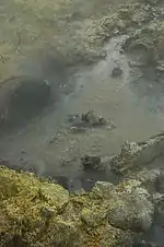
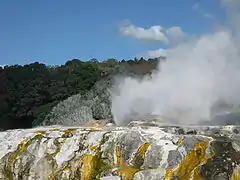
Thermal activity is at the heart of much of Rotorua's tourist appeal. Geysers and bubbling mud pools, hot thermal springs and Te Wairoa ("The Buried Village") — so named after it was buried by the 1886 Mount Tarawera eruption— are within easy reach of Rotorua.
In Kuirau Park, to the west end of Rotorua, hot bubbling mud pools dot the park.[12] Visitors can soak their feet in hot pools.
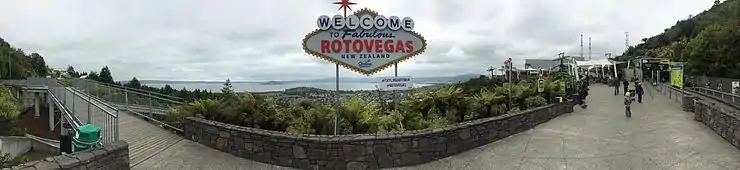
A common nickname for Rotorua is "Sulphur City" due to the hydrogen sulphide emissions, which gives the city a smell similar to "rotten eggs",[1] as well as "Rotten-rua" combining its legitimate name and the rotten smell prevalent. Another common nickname is "Roto-Vegas", likening the city's own strip of road flanked by businesses and restaurants to that of Las Vegas.
The especially pungent smell in the central-east 'Te Ngae' area is due to the dense sulphur deposits located next to the southern boundary of the Government Gardens, in the area known as 'Sulphur Point'.
Lakes
The Rotorua region has 17 lakes, known collectively as the Lakes of Rotorua. Fishing, waterskiing, swimming and other water activities are popular in summer. The lakes are also used for event venues; Rotorua hosted the 2007 World Waterski Championships and Lake Rotorua was the venue for the World Blind Sailing Championships in March 2009.[13] Lake Rotorua is also used as a departure and landing point for float planes.
Other activities
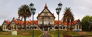
Rotorua is also home to botanical gardens and historic architecture. Known as a spa town and major tourist resort since the 1800s, many of its buildings hint at this history. Government Gardens, close to the lake-shore at the eastern edge of the town, are a particular point of pride. The Rotorua Museum of Art and History is housed in the large Tudor-style bath house building while the Art Deco style Blue Baths, noted for their embrace of mixed sex bathing in the 1930s, remain open today.
Another of Rotorua's attractions is mountain biking. Whakarewarewa Forest was listed as one of the Top 8 locations globally by Red Bull Magazine in 2012. The forest includes over 100 km of mountain bike trails and in August 2006 was a host of the UCI Mountain Bike and Trials World Championships. In 2015 Rotorua hosted the Southern Hemisphere leg of the Crankworx mountain bike event.
The Rotorua Pistol club is among the largest in the Southern Hemisphere and hosted the 2013 Australasian IPSC Handgun Championship.
The Kaituna River, 15 minutes drive north east of the CBD provides class 5 whitewater kayaking and rafting through a spectacular tree lined gorge.
The region is home to 16 lakes. These are popular for recreation such as boating and fishing. Several of the lakes are stocked for sports fishing with trout from the Fish and Game New Zealand hatchery at Ngongotahā.
Local government

In October 2013, Steve Chadwick was elected Mayor of Rotorua and was re-elected in the 2016 mayoral election and the 2019 mayoral election. She previously served as the Member of Parliament for Rotorua between 1999 and 2008, and served as a Cabinet Minister in the Fifth Labour Government.[14]
Media
Rotorua has several media organisations, including the Rotorua Daily Post, More FM Rotorua and The Hits Rotorua.
Transport
Road
Rotorua is served by state highways 5, 30, and 30A, and the Thermal Explorer Highway touring route, with state highways 33 and 36 terminating on the outskirts of the town.
State Highway 5, running concurrently with the Thermal Explorer Highway, is the main north–south route through Rotorua, bypassing the town centre to the west. North of the town at Ngongotahā, State Highway 36 splits off to provide a route to Tauranga via Pyes Pa, while State Highway 5 turns westward, connecting to State Highway 1 at Tīrau and providing the main route into Rotorua from Hamilton and Auckland. To the south, State Highway 5 provides the main route from Taupō, Hawke's Bay, Manawatu, and Wellington.
State Highway 30 runs southwest to northeast through the town. It enters the town in the southwest (running concurrently with SH 5), before crossing the southern suburbs to the shore of Lake Rotorua east of the town centre. It then runs through the suburb of Te Ngae, before splitting off SH 33 to continue eastwards.
State Highway 30A runs northwest to southeast, connecting State Highways 5 and 30 with each other via the town centre.
Bus
Rotorua has a local bus service,[15] with 11 routes under the Baybus brand, serving the urban area, mostly at half hourly intervals,[16] operated by Reesby Buses.[17] Bike racks were introduced in 2017[18] and Bee cards for fares on 27 July 2020.[19] The city is also served by InterCity[20] and Skip buses to many parts of North Island[21] and services to local tourist sites.[22]
History
Edwin Robertson, who died aged 74 in 1931,[23] started with pack horses in 1869 and ran coaches from 1873.[24] In 1902 the Tauranga route was sold and became Robertson & Co,[25] then, about 1903, Rotorua Motor Coaching Co. Ltd.[26] In 1904 Hot Lakes Transport, which ran trips to Taupo,[27] Waiotapu and all the lakes,[28] and Rotorua Motor Coaching added motor cars to their fleets of coaches.[29] In 1905 E. Robertson & Co moved from Ohinemutu to the new town, close to the new railway station,[24] which remained the main stop until InterCity moved to their stop from Hinemoa / Fenton Street[30] to the Tourism Office in 1995.[31] The last coach ran in 1919.[32] When Hot Lakes Transport's assets were sold in 1920, they had 10 coaches and 3 motor cars.[33] In September of 1920 Rotorua Motor Transport Co. was formed and took over Hot Lakes Transport Co. and Rotorua Motor Coaching Co,[34] continuing with similar services.[35] In 1926 a consortium of local operators formed Rotorua Bus Co.[36] During 1922 Kusab's transport company became K Motors,[32] which was taken over by the railways in 1938.[37] Rotorua Motor Transport and Rotorua Bus Co followed in 1940[38] and all became part of New Zealand Railways Road Services.[26]
Air
Rotorua Regional Airport is located 9 km (6 mi) northeast of the city centre, off State Highway 30. Air New Zealand provides daily turbo-prop flights between Rotorua and Auckland, Wellington, and Christchurch airports. Previously Qantas also operated Boeing 737 aircraft from Christchurch, but upon their departure from domestic flights in New Zealand this was discontinued.
Scenic and chartered flights in both helicopters and float planes are operated by Volcanic Air who are based on Rotorua's lake front.
From 2009 to 2015 there was also an international link, with direct Sydney to Rotorua flights.[39]
Rail
Rotorua is connected to the rail network by the Rotorua Branch line from Putaruru. Up until 2001, passenger trains ran from Auckland to Rotorua via Hamilton daily using Silver Fern railcars, terminating north of the town centre at Koutu (the original station on Amohau Street was closed and relocated to Koutu in 1989). However, owing to poor advertising of the service and the location of the station being a 15-minute walk from the town centre in an industrial area, passenger services stopped in October 2001. Freight services on the line declined over the decades up until the nightly freight service stopped in 2000, largely due to a continual move of freight and passengers onto road transport using ever-improving highways in the region. The line is currently disused.
Education
Tertiary
Rotorua is home to the central campus of Toi Ohomai Institute of Technology, which provides a range of Certificate, Diploma and a limited number of degree-level programmes. The largest programmes on offer are Te Reo Māori (Māori language), nursing, forestry, business, computing, tourism and hospitality. Toi Ohomai Institute of Technology is the 3rd largest tertiary education institution in New Zealand with campuses throughout the Bay of Plenty region.
Secondary
Rotorua has five secondary schools:
- John Paul College, a co-educational, state-integrated Catholic school for Years 7–13 with about 1200 students[40]
- Rotorua Boys' High School, a state boys school for Years 9–13 with about 1000 students[41]
- Rotorua Girls' High School, a state girls school for Years 9–13 with about 600 students[42]
- Rotorua Lakes High School serving the eastern suburbs. A co-educational state school for Years 9–13 with about 700 students[43]
- Western Heights High School serving the western suburbs. A co-educational state school for Years 9–13 with about 1200 students[44]
Students can also attend Te Rangihakahaka Centre for Science and Techbnology, a Māori- and English-medium special character school from Years 1-10.[45] It currently has around 100 students.[46] Students here need to attend a mainstream secondary school or Kura Kaupapa Māori for their senior secondary schooling.
Kura Kaupapa Māori (Māori language immersion schools)
Rotorua has four Kura Kaupapa Māori:
- Te Wharekura o Ngāti Rongomai years 0-13 with about 115 students in eastern Rotorua[47]
- Te Kura Kaupapa Māori O Te Koutu years 0–13 with about 240 students in western Rotorua[48]
- Te Kura Kaupapa Māori O Ruamata years 0–13 with about 240 students in semi-rural eastern Rotorua[49]
- Te Kura Kaupapa Māori O Hurungaterangi years 0–8 with about 80 students in central Rotorua[50]
Notable people
See also Category:People from Rotorua
- Valerie Adams, Olympic shot putter
- Steven Adams, basketball player (Oklahoma City Thunder)
- Israel Adesanya, UFC mixed martial artist
- Michael Barker, drummer
- Jean Batten, aviator
- Sam Bewley, Olympic cyclist
- Manu Bennett, actor
- Trent Boult, New Zealand cricketer
- Scott Curry, All Blacks 7s, Bay of Plenty 7s
- Cliff Curtis, actor
- Julian Dean, road racing cyclist
- Mike Delany, rugby union player, All Black
- Dame Susan Devoy, squash player
- Tom Donnelly, All Black, rugby union player
- Alan Duff, writer
- Gary Jeshel Forrester, musician, writer, academic
- Jack Foster, Olympic marathon runner
- Tony Gordon, rugby league player and coach
- Bevan Hari, hockey player
- Dylan Hartley, rugby union player (For the English National Team.)
- Tame Iti, maori activist
- David Kosoof, Olympic hockey player
- Danny Lee, professional golfer
- Dennis List, poet and writer
- Angus Hikairo Macfarlane, educator
- Steve McDowall, All Black
- Hinematau McNeill (also writing as Naomi Te Hiini) academic and treaty negotiator
- Jon Mark, Musician. solo artist and co-founder of Mark-Almond
- Tony Marsh, rugby union player (for French national team)
- Elizabeth Marvelly, soprano
- Liam Messam, rugby union player (for Waikato and NZ)
- Sir Howard Morrison, entertainer
- Temuera Morrison, actor
- Craig Newby, All Black
- Caleb Ralph, All Black
- William Ripia, rugby union player (Wellington Hurricanes, Western Force, Bay of Plenty, Otago Highlanders, Maori All Black)
- Joe Royal, rugby union player (Bay of Plenty Steamers and Māori All Blacks)
- Ben Sandford, Olympic men's skeleton racer
- Wayne "Buck" Shelford, former All Black
- Miriama Smith, actress
- Sir Peter Tapsell, politician
- Ngahuia Te Awekotuku, academic, scholar activist, Emeritus Professor
- Sir Gordon Tietjens, New Zealand and Samoan Sevens rugby coach
- Jared Waerea-Hargreaves, rugby league player (Sydney Roosters and New Zealand Kiwis)
- Dean Whare, rugby league player (Penrith Panthers and New Zealand Kiwis)
References
- Collins, Simon (9 July 2003). "Sulphur City gases under scrutiny". The New Zealand Herald. Retrieved 7 June 2009.
- Corbett, Jan (20 January 2001). "Rumblings in geyserland". The New Zealand Herald. Retrieved 7 June 2009.
- "Population estimate tables - NZ.Stat". Statistics New Zealand. Retrieved 22 October 2020.
- "Rotorua". Merriam-Webster Dictionary.
- "Rotorua". Dictionary.com Unabridged. Random House.
- "Rotorua". Waikato Regional Council. Archived from the original on 8 February 2013. Retrieved 27 December 2012.
- Wises New Zealand Guide, 7th Edition, 1979. p383.
- "1966 Encyclopaedia of New Zealand – Te Ara: The Encyclopedia of New Zealand". Archived from the original on 23 October 2007.
- "Chapman, Anne Maria and Chapman, Thomas – Biography – Te Ara: The Encyclopedia of New Zealand".
- "About Rotorua's History". Rotorua District Library. Retrieved 26 October 2012.
- "Climate Data and Activities". NIWA. Retrieved 19 October 2013.
- "Rotorua park eruption spews out mud and rocks". The New Zealand Herald. The Daily Post. 13 December 2006. Retrieved 5 November 2011.
- "New British Sailing Team Sets Sights On Cup Glory". sailing.org.
- "Local vote: District Councils ( A to R)". The New Zealand Herald. 11 October 2004.
- "Rotorua Urban - Baybus". www.baybus.co.nz.
- "Rotorua Urban - Baybus". www.baybus.co.nz. Retrieved 9 September 2020.
- "Travel by Bus - Rotorua Lakes Council". www.rotorualakescouncil.nz. Retrieved 9 September 2020.
- "Tauranga to get bike racks for buses". The New Zealand Herald. 25 August 2017. ISSN 1170-0777. Retrieved 31 August 2018.
- "Buses and transport". Bay of Plenty Regional Council | Toi Moana. Retrieved 9 September 2020.
- InterCity. "New Zealand InterCity® Bus Route Map | NZ's #1 Bus Network". www.intercity.co.nz. Retrieved 9 September 2020.
- "Bus to Rotorua". skip.travel. Retrieved 9 September 2020.
- "Rotorua Bus and Coach Tours". New Zealand Tourism Guide.
- "PIONEER PASSES. BAY OF PLENTY TIMES". paperspast.natlib.govt.nz. 21 August 1931. Retrieved 10 September 2020.
- "ROBERTSON'S NEW STABLES. HOT LAKES CHRONICLE". paperspast.natlib.govt.nz. 25 December 1895. Retrieved 9 September 2020.
- "BAY OF PLENTY TIMES". paperspast.natlib.govt.nz. 5 March 1902. Retrieved 9 September 2020.
- "TRANSFER OF SERVICE. BAY OF PLENTY BEACON". paperspast.natlib.govt.nz. 29 April 1940. Retrieved 9 September 2020.
- "Hot Lakes Transport Co. c1900-1920". rotorua.kete.net.nz. Retrieved 10 September 2020.
- "Hot Lakes Transport Co. Map of Tours c1910". rotorua.kete.net.nz. Retrieved 10 September 2020.
- "MOTORS AND MOTORING. NEW ZEALAND HERALD". paperspast.natlib.govt.nz. 10 September 1904. Retrieved 9 September 2020.
- "Car outside Tourist Booking office; Circa 1910; OP-823 on NZ Museums". eHive. Retrieved 10 September 2020.
- "Tourism Rotorua & Bus Stop". rotorua.kete.net.nz. Retrieved 9 September 2020.
- "Rotorua Transport Companies of Yesteryear". Rotorua Library. 30 October 2015. Retrieved 9 September 2020.
- "LOCAL AND GENERAL. TE PUKE TIMES". paperspast.natlib.govt.nz. 28 September 1920. Retrieved 9 September 2020.
- "BAY OF PLENTY TIMES". paperspast.natlib.govt.nz. 9 September 1920. Retrieved 9 September 2020.
- "Rotorua Motor Transport Co. Ltd c1916". rotorua.kete.net.nz. Retrieved 10 September 2020.
- "COMMERCIAL. NEW ZEALAND HERALD". paperspast.natlib.govt.nz. 11 June 1926. Retrieved 9 September 2020.
- "Legends of the Lakes… — Rotorua". nzetc.victoria.ac.nz. Retrieved 10 September 2020.
- "STATE PURCHASE. GISBORNE HERALD". paperspast.natlib.govt.nz. 11 December 1940. Retrieved 9 September 2020.
- "Rotorua's last flight to Sydney takes off", Apr 27, 2015, NZ Herald
- "Student Population – John Paul College". Ministry of Education. Retrieved 30 July 2020.
- "Student Population – Rotorua Boys High School". Ministry of Education. Retrieved 30 July 2020.
- "Student Population – Rotorua Girls High School". Ministry of Education. Retrieved 30 July 2020.
- "Student Population – Rotorua Lakes High School". Ministry of Education. Retrieved 30 July 2020.
- "Student Population – Western Heights High School". Ministry of Education. Retrieved 30 July 2020.
- "Te Rangihakahaka Centre for Science and Technology". Te Rangihakahaka. Retrieved 30 July 2020.
- "Student Population - Te Rangihakahaka Centre for Science and Technology". Ministry of Education. Retrieved 30 July 2020.
- "Student Population – Te Wharekura o Ngāti Rongomai". Ministry of Education. Retrieved 30 July 2020.
- "Student Population – Te Kura Kaupapa Māori O Te Koutu". Ministry of Education. Retrieved 30 July 2020.
- "Student Population – Te Kura Kaupapa Māori O Ruamata". Ministry of Education. Retrieved 30 July 2020.
- "Student Population – Te Kura Kaupapa Māori O Hurungaterangi". Ministry of Education. Retrieved 30 July 2020.
External links
| Wikimedia Commons has media related to Rotorua. |
- Chisholm, Hugh, ed. (1911). . Encyclopædia Britannica (11th ed.). Cambridge University Press.
- Info-Rotorua | Visitor Information TV & website
- Official Rotorua YouTube channel
- Rotorua District Council official website
- Rotorua Tourism official website
 Rotorua travel guide from Wikivoyage
| Authority control |
|---|