Rubio Peak Formation
The Rubio Peak Formation is a geologic formation in southwestern New Mexico.[1] Radiometric dating dates it back to the middle Eocene to early Oligocene Epochs.[2]
| Rubio Peak Formation Stratigraphic range: late Eocene to Oligocene | |
|---|---|
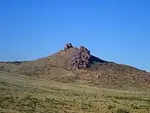 Monument Peak, located near Lake Valley, New Mexico, USA, is underlain by Rubio Peak Formation. | |
| Type | Formation |
| Unit of | Spears Group |
| Underlies | Sugarlump Tuff |
| Overlies | early Tertiary plutons |
| Thickness | 5,000 feet (1,500 m) |
| Location | |
| Coordinates | 32.6899504°N 107.8944869°W |
| Region | New Mexico |
| Country | United States |
| Type section | |
| Named by | W.E. Elston |
| Year defined | 1953 |
 Rubio Peak Formation (the United States) 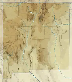 Rubio Peak Formation (New Mexico) | |
Description
The formation is volcanic, consisting mostly of flows of amphibole latites to pyroxene andesites[2] and associated volcaniclastics and tuffs.[3] The flows have a silica content of 59-63%. The appearance is highly variable, from pinkish gray to red to brown to black, with large to small phenocrysts and with glassy to fully crystalline texture. However, the chemical composition is reasonably uniform across the formation.[2] The maximum thickness is as much as 5,000 feet (1,500 m). It lies on older Tertiary intrusive rocks and is overlain[3] and interfingers with[4] the Sugarlump Tuff.
History of investigation
The formation first appears informally in a chart prepared by R.M. Hernon and coinvestigators in 1953,[1] but was apparently first used in an unpublished paper by W.E. Elston that same year.[5] C.H. Dane and G.O. Bachman (1961) mapped the formation throughout southwestern New Mexico and extended the definition to include some flows that appeared to be of Cretaceous age,[6] but subsequent work has restricted the definition to flows near the type area and of Eocene to Olicocene age.[4] The formation was assigned to the Spears Group by Steven M. Cather and coinvestigators in 1994, who excluded the volcanic units and restricted the formation to the associated volcaniclastics.[7]
Footnotes
References
- Cather, Steven M.; Chamberlin, R.M.; Ratte, J.C. (1994). "Tertiary stratigraphy and nomenclature for western New Mexico and eastern Arizona" (PDF). New Mexico Geological Society Field Conference Series. 45: 259–266. Retrieved 25 August 2020.
- Clemons, R.E. (1982). "Geology of Massacre Peak quadrangle, Luna County, New Mexico". New Mexico Bureau of Mines and Mineral Resources Geologic Map. 51. Retrieved 6 August 2020.
- Dane, C.H.; Bachman, G.O. (1961). "Preliminary geologic map of the southwestern part of New Mexico". U.S. Geological Survey Miscellaneous Investigations Series Map. I-344. Retrieved 6 August 2020.
- Hernon, R.M.; Jones, W.R.; Moore, S.L. (1953). "Some geological features of the Santa Rita quadrangle" (PDF). New Mexico Geological Society Field Conference Guidebook. 4: 117–129. Retrieved 6 August 2020.
- Hernon, R.M.; Jones, W.R.; Moore, S.L. (1964). "Geology of the Santa Rita quadrangle, New Mexico". U.S. Geological Survey Geologic Quadrangle Map. GQ-306. Retrieved 6 August 2020.
- Jicha, H.L., Jr. (1954). "Geology and mineral deposits of Lake Valley quadrangle, Grant, Luna, and Sierra Counties, New Mexico" (PDF). New Mexico Bureau of Mines and Mineral Resources Bulletin. 37. Retrieved 6 August 2020.
- Strangway, D.W.; Simpson, J.; York, D. (1976). "Paleomagnetic studies of volcanic rocks from the Mogollon Plateau area of Arizona and New Mexico,". New Mexico Geological Society Special Publication. 5: 119–125.