Rudrón Valley
The Rudrón Valley (Spanish: 'Valle del Rudrón') is a valley of the province of Burgos, in the autonomous community of Castilla y León, Spain, that borders the autonomous community of Cantabria.
Valle del Rudrón | |
|---|---|
 Valle del Rudrón Location in Spain | |
| Coordinates: 42.689444°N 3.854333°W | |
| Elevation | 980- 677 m (−1,241 ft) |
From a structural standpoint, the relief is organized around a large morphostructural unit: an extensive moorland. The River Rudrón divides and separates both sides of moorland. The River Rudrón [1] divides and separates both sides of moorland creating Rudrón Valley, leaving on the left the moor of La Lora and right the moor of Masa.[2]
Geographical description
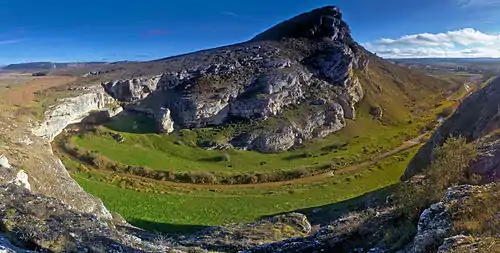
The River Rudrón through a process of epigenesis has excavated and drilled sedimentary limestones that extensive moorland, moorland that forms the watershed of this river. The River Rudrón rises in the land of the Tozo, specifically in the town of San Mames of Abar where it is called the River Urón.[4] Collect water from some rivers of Tozo.[5]
The valley is interrupted by having a special feature, become underground river between Basconcillos of Tozo and the Barrio Panizares and where the river rises a second time. After millions of years the product of this erosion has generated the River Rudrón slopes and steep slopes, sometimes spectaculars. In the valley bottom lands dominated limestone, clay of Quaternary.
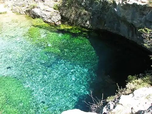
This erosion has also generated numerous springs, streams, fountains and creeks to break the different aquifers, in some cases spectacular as the Blue Pit (Spanish: 'Pozo Azul'). The Blue Pit is one of the most visited places of Rudrón Valley.[6]
In this valley villages are located:
- Barrio Panizares
- Hoyos del Tozo
- Moradillo del Castillo
- Santa Coloma del Rudrón
- Bañuelos del Rudrón
- Tablada del Rudrón
- Tubilla del Agua
- Covanera
- San Felices del Rudrón
- Valdelateja
References
- Río Rudrón. ELUE. Last modified: 2014-01-05 at 14:32. Accessed: 2014-03-18.
- De Mesa, Pedro Antonio (1985) Reconocimiento hidrológico del valle del Ebro. Rafael Anoz. Madrid. pp. 19-20
- Río Urón. ELUE. Last modified: 2013-12-10 at 17:21. Accessed: 2014-03-17.
- Pendas Fernández, Fernando & Menéndez Casares, Eduardo & Heredia Carballo, Nemesio (I.T.G.E.) (1988-89): MGE. 1:50.000. Polientes. 134 (18-08). IGME. IGN. Cartografía: Madrid S.A. 1.972. NIPO: 241-93-009-3. "Archived copy". Archived from the original on 2013-12-07. Retrieved 2013-12-07.CS1 maint: archived copy as title (link)
- De Mesa, Pedro Antonio (1985) Mapa del Instituto Geológico y Minero de España nº 49-50. Instituto Geológico y Minero de España. Madrid. 1958. pp. 170
- / Marius van Heiningen: Pozo Azul: el porqué de su localización. Viewed: 25-09-2012