São Jacinto Airport
São Jacinto Airport, officially designated Aveiro Municipal Aerodrome (Portuguese: Aeródromo Municipal de Aveiro), is an aerodrome near the city of Aveiro in Portugal. It is located on a peninsula, between the Atlantic Ocean and the Vouga River estuary, in the parish of São Jacinto, near to the harbour of Aveiro, as well as the Costa de Prata (Silver Coast) beaches. It has a single runway in the 17/35 direction and a relatively large apron and has been operated in the past by all branches of the Portuguese Armed Forces. It is home to an air club, Aeroclube de Aveiro,[1] but is currently closed to civilian traffic due to lack of certification.[2]
Aeródromo Municipal de Aveiro São Jacinto Airport | |||||||||||
|---|---|---|---|---|---|---|---|---|---|---|---|
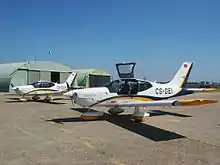
 Two Socata TB-200GTs at Aveiro | |||||||||||
| Summary | |||||||||||
| Airport type | Public | ||||||||||
| Operator | Câmara Municipal de Aveiro | ||||||||||
| Serves | Aveiro | ||||||||||
| Elevation AMSL | 26 ft / 8 m | ||||||||||
| Coordinates | 40°39′15″N 008°44′37″W | ||||||||||
| Runways | |||||||||||
| |||||||||||
History
The airfield dates back to World War I, with the creation of an anti-submarine hydroplane base by the French Naval Aviation established a base on April 1, 1918. With the end of the war the base was integrated into the Portuguese Naval Aviation and in 1927 the Admiral Gago Coutinho Naval Aviation School (Portuguese: Escola de Aviação Naval Almirante Gago Coutinho) was installed at its facilities. A runway was then constructed in 1937 to allow the operation of conventional aircraft from the base.[3][4]
In 1953, with the creation of the Portuguese Air Force the previous year, the base is transferred to that branch. In 1977 the air base is deactivated and the base's garrison is then used by the Air Force's airborne troops as Airborne Troops Operational Base No. 2 (Portuguese: Base Operacional de Tropas Pára-quedistas Nº2, BOPT2) and its aviation facilities are designated as Maneuvers Airfield No. 2 (Portuguese: Aeródromo de Manobra Nº 2, AM2) until their deactivation in 1992 as an independent unit. With the integration of the airborne troops in the Army the base was re-designated S. Jacinto Military Area (Portuguese: Área Militar de S. Jacinto, AMSJ).[3][5][6]
Civilian use
In 1993 the Air Force signed an agreement with the local government of the Aveiro Municipality, through the Aeroclube de Aveiro, to allow the use of the aviation infrastructures for civilian use. On September 4, 1993, the airfield was open to civilian traffic and was re-designated as Aveiro Municipal Aerodrome.[3][6]
Military designations
| Date | Name | Native Portuguese name | Operator |
|---|---|---|---|
| 1919–1933 | S. Jacinto Naval Aviation Centre | Centro de Aviação Naval de S. Jacinto | Portuguese Navy |
| 1933–1953 | Gago Coutinho Naval Aviation School | Escola de Aviação Naval Almirante Gago Coutinho | |
| 1953–1957 | Air Base No. 5 | Base Aérea Nº 5 (BA5)[9] | Portuguese Air Force |
| 1957–1958 | Base Aerodrome No. 2 | Aeródromo-Base Nº 2 (AB2) | |
| 1958–1978 | Air Base No. 7 | Base Aérea Nº 7 (BA7)[10][11] | |
| 1977–1992 | Maneuvers Airfield No. 2 | Aeródromo de Manobra Nº 2 (AM2) | |
References
- "Aerodromos em Portugal: AVEIRO (São Jacinto)" (in Portuguese). Archived from the original on August 26, 2014. Retrieved March 6, 2013.
- "Exército volta a impedir acesso ao Aero Clube". Notícias de Aveiro (in Portuguese). September 13, 2012. Retrieved 5 March 2013.
- "Área militar" (in Portuguese). CNFASJ. Retrieved March 6, 2013.
- Azimute 192, pp. 9, 10
- Azimute 192, p. 10
- "Presença Militar em S. Jacinto" (in Portuguese). Retrieved March 6, 2013.
- "Aeronautical infrastructures". October 20, 2009. Archived from the original on October 20, 2009. Retrieved March 6, 2013.CS1 maint: unfit URL (link)
- Azimute 192, pp. 9, 10, 11
- Decreto-Lei 40950. December 28, 1956
- Portaria n.º 16993. December 20, 1957
- Despacho n.º 18/78, CEMFA
Bibliography
- Tadeu, Viriato (1984). Quando a Marinha tinha Asas. Lisbon.
- Lopes, Mário Canongia (1989). Os Aviões da Cruz de Cristo. Lisbon: Dinalivro.
- "Regimento de Infantaria N.º 10" [Infantry Regiment No. 10] (PDF). Azimute (in Portuguese). Portuguese Army (192): 9–14. December 2011. Retrieved March 6, 2013.