Saint-Bauld
Saint-Bauld is a former commune in the Indre-et-Loire department in central France. On 1 January 2018, it was merged into the new commune of Tauxigny-Saint-Bauld.[2]
Saint-Bauld | |
|---|---|
Part of Tauxigny-Saint-Bauld | |
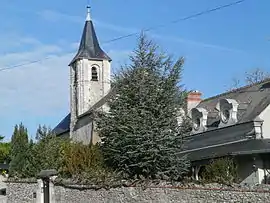 The church in Saint-Bauld | |
Location of Saint-Bauld 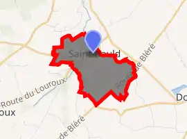
| |
 Saint-Bauld  Saint-Bauld | |
| Coordinates: 47°10′51″N 0°50′17″E | |
| Country | France |
| Region | Centre-Val de Loire |
| Department | Indre-et-Loire |
| Arrondissement | Loches |
| Canton | Loches |
| Commune | Tauxigny-Saint-Bauld |
| Area 1 | 4.11 km2 (1.59 sq mi) |
| Population (2017)[1] | 194 |
| • Density | 47/km2 (120/sq mi) |
| Time zone | UTC+01:00 (CET) |
| • Summer (DST) | UTC+02:00 (CEST) |
| Postal code | 37310 |
| Elevation | 77–103 m (253–338 ft) |
| 1 French Land Register data, which excludes lakes, ponds, glaciers > 1 km2 (0.386 sq mi or 247 acres) and river estuaries. | |
Population
| Year | Pop. | ±% |
|---|---|---|
| 1793 | 163 | — |
| 1800 | 164 | +0.6% |
| 1806 | 179 | +9.1% |
| 1821 | 173 | −3.4% |
| 1831 | 184 | +6.4% |
| 1836 | 192 | +4.3% |
| 1841 | 216 | +12.5% |
| 1846 | 221 | +2.3% |
| 1851 | 232 | +5.0% |
| 1856 | 227 | −2.2% |
| 1861 | 214 | −5.7% |
| 1866 | 206 | −3.7% |
| 1872 | 225 | +9.2% |
| 1876 | 212 | −5.8% |
| 1881 | 224 | +5.7% |
| 1886 | 216 | −3.6% |
| 1891 | 211 | −2.3% |
| 1896 | 190 | −10.0% |
| 1901 | 201 | +5.8% |
| 1906 | 208 | +3.5% |
| 1911 | 214 | +2.9% |
| 1921 | 175 | −18.2% |
| 1926 | 187 | +6.9% |
| 1931 | 181 | −3.2% |
| 1936 | 196 | +8.3% |
| 1946 | 187 | −4.6% |
| 1954 | 182 | −2.7% |
| 1962 | 174 | −4.4% |
| 1968 | 173 | −0.6% |
| 1975 | 132 | −23.7% |
| 1982 | 115 | −12.9% |
| 1990 | 159 | +38.3% |
| 1999 | 167 | +5.0% |
| 2006 | 191 | +14.4% |
| 2009 | 206 | +7.9% |
References
- Téléchargement du fichier d'ensemble des populations légales en 2017, INSEE
- Arrêté préfectoral 11 September 2017 (in French)
| Wikimedia Commons has media related to Saint-Bauld. |
| Authority control |
|---|
This article is issued from Wikipedia. The text is licensed under Creative Commons - Attribution - Sharealike. Additional terms may apply for the media files.