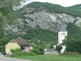
Saint-Benoît, Ain
Saint-Benoit is a former commune in the Ain department in eastern France. On 1 January 2016, it was merged into the new commune Groslée-Saint-Benoît.[2]
Saint-Benoit | |
|---|---|
Part of Groslée-Saint-Benoît | |
 | |
Location of Saint-Benoit 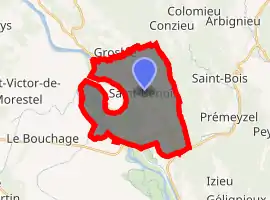
| |
 Saint-Benoit  Saint-Benoit | |
| Coordinates: 45°42′00″N 5°35′00″E | |
| Country | France |
| Region | Auvergne-Rhône-Alpes |
| Department | Ain |
| Arrondissement | Belley |
| Canton | Belley |
| Commune | Groslée-Saint-Benoît |
| Area 1 | 21.65 km2 (8.36 sq mi) |
| Population (2017)[1] | 833 |
| • Density | 38/km2 (100/sq mi) |
| Time zone | UTC+01:00 (CET) |
| • Summer (DST) | UTC+02:00 (CEST) |
| Postal code | 01300 |
| Elevation | 201–778 m (659–2,552 ft) (avg. 206 m or 676 ft) |
| 1 French Land Register data, which excludes lakes, ponds, glaciers > 1 km2 (0.386 sq mi or 247 acres) and river estuaries. | |
Population
| Year | Pop. | ±% |
|---|---|---|
| 1793 | 972 | — |
| 1800 | 1,030 | +6.0% |
| 1806 | 1,112 | +8.0% |
| 1821 | 1,165 | +4.8% |
| 1831 | 1,221 | +4.8% |
| 1836 | 1,200 | −1.7% |
| 1841 | 1,268 | +5.7% |
| 1846 | 1,260 | −0.6% |
| 1851 | 1,326 | +5.2% |
| 1856 | 1,260 | −5.0% |
| 1861 | 1,204 | −4.4% |
| 1866 | 1,206 | +0.2% |
| 1872 | 1,207 | +0.1% |
| 1876 | 1,118 | −7.4% |
| 1881 | 1,036 | −7.3% |
| 1886 | 1,023 | −1.3% |
| 1891 | 986 | −3.6% |
| 1896 | 974 | −1.2% |
| 1901 | 890 | −8.6% |
| 1906 | 883 | −0.8% |
| 1911 | 826 | −6.5% |
| 1921 | 818 | −1.0% |
| 1926 | 792 | −3.2% |
| 1931 | 780 | −1.5% |
| 1936 | 741 | −5.0% |
| 1946 | 667 | −10.0% |
| 1954 | 607 | −9.0% |
| 1962 | 530 | −12.7% |
| 1968 | 504 | −4.9% |
| 1975 | 486 | −3.6% |
| 1982 | 548 | +12.8% |
| 1990 | 488 | −10.9% |
| 1999 | 582 | +19.3% |
| 2008 | 736 | +26.5% |
See also
References
- Téléchargement du fichier d'ensemble des populations légales en 2017, INSEE
- Arrêté préfectoral 30 December 2015 (in French)
| Wikimedia Commons has media related to Saint-Benoît, Ain. |
This article is issued from Wikipedia. The text is licensed under Creative Commons - Attribution - Sharealike. Additional terms may apply for the media files.